Holy Takpa Siri mountain
Share on Social
TREKKING IN THE TAWANG TRACT
Visit to Tawang Tract, Western Arunachal Pradesh
2003
Whenever I am visiting New Delhi, I love to spend an afternoon with the famous writer Bill Aitken over a lunch. We go to our favourite restaurant, watch cricket and spend a leisurely time with this master who knows Himalaya well and writes about them with deep affection. An afternoon with him can leave you with ideas for a year ! ‘Harish you must now visit the east’, he told me, almost like Horace Greeley’s advice to young investors.[1] ‘You have gone to many valleys in the central and western Himalaya but it should not happen that you miss the eastern Himalaya like Arunachal Pradesh and Bhutan’. That was the germ that he planted in my mind a few years ago and I decided to act on it in the year 2003. No sooner, I started planning for a trip to Arunachal Pradesh the first person that came to my mind was Romesh Bhattacharji, a retired government officer who had spend several years in the northeast. He was an authority on these areas having travelled extensively there, observed well and finally had written a book on the northeast.[2] So armed with suggestions from these two gentlemen I was set to enjoy the east. And to qualify for being ‘young’ trekkers we had a good average age between three of us!
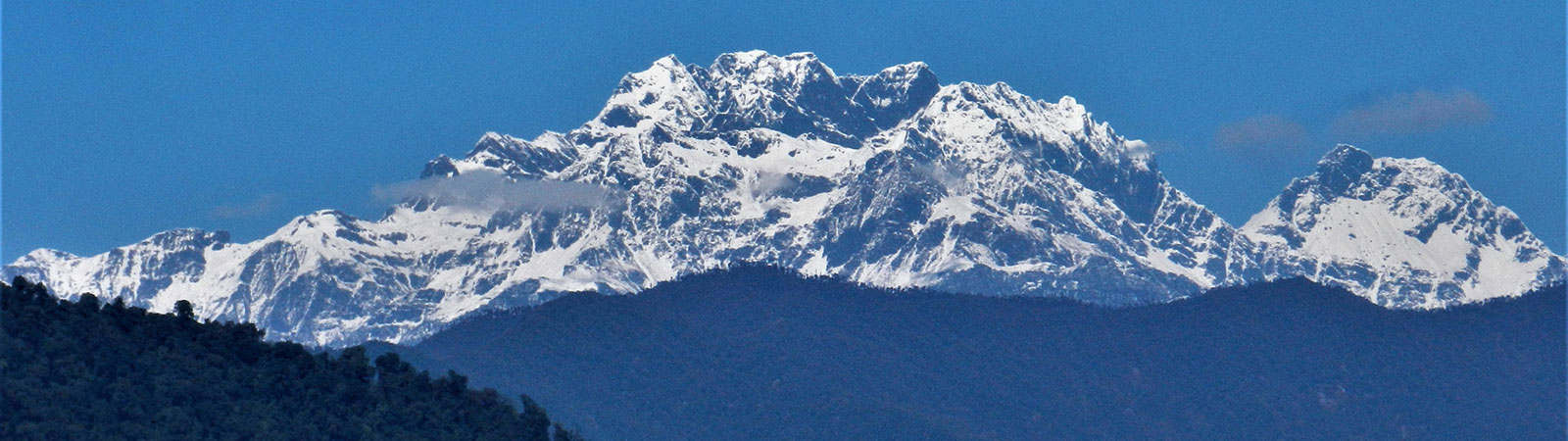
Mountains of Arunachal Pradesh
This part of Arunachal Pradesh from the border of Bhutan till Tsangpo (Brahamaputra) gorge, where it enters India, is the easternmost part of the Indian Himalayan range. It was classified as the ‘Assam Himalaya’. Most high peaks here lie on the McMahon Line, the international border, or little to the south of it. The valleys towards north across the border are flat leading to the Tibetan plains while valleys to the south fall steeply towards India into thick forest of Arunachal Pradesh. Some of the well-known peaks are Gorichen group – a group of six peaks, Kangto 7042 m, Unnamed peaks around 6400 m and Nyegi Kangsang 6983 m. The peak of Takpa Shiri, around which both Monpas and Tibetans performed a circumambulation, Kingkor or a Ringkor, (a wider circle), lies entirely in Tibet and both this circumambulations have now been stopped by the armies on both sides. A loss of a fine tradition! [3]
Gorichen II was first climbed in 1966 by an Indian army team. Peak Kangto was climbed by the Japanese in 1988 approaching it from the Tibetan plateau in the north. Nyegi Kangsang (6983 m) was attempted in 1995 by a team from Indian Mountaineering Foundation which mistakenly claimed an ascent, proved wrong later. Today on the latest maps, Kangto (locally known as Sher Kangri, the ‘eastern mountain’) is 7042 m and stands as the highest peak in Arunachal Pradesh (and on the McMahon Line) and the only peak above 7000 m in the eastern Indian Himalaya, east of Bhutan. The Himalayan range east of the Tsangpo gorge, where it enters India, peters out into smaller mountains.
Brief History of Tawang Tract
To begin my affair with the east I decided to trek in the Western Arunachal Pradesh, areas near Tawang.
The ‘Tawang Tract’, as it was known during the early days, was a remote unknown area till middle of the last century. It was a thinly populated area with Monpa tribes and was known as the ‘Monyul’. For centuries Monpas travelled to Tibet for supplies and trade and the area was administered by the monasteries in Tibet or by the Tibetan kings. The head lama of Tawang monastery was appointed by the Tashilumpho gompa, Shigatse in Tibet and the sixth Dalai Lama, who was born at Tawang, travelled from here to Lhasa .
Nain Singh
Though Monpas and Tibetans travelled across the passes from earliest years the first known detailed account of travel and its mountains was brought by Pundit Nain Sigh. He was working incognito for Survey of India and had travelled from Leh to Lhasa in 1874 –75. He was surveying the area and taking notes for the British. His intention was to proceed to Peking, but fearing detection he changed plans and turned south. Crossing Brahmaputra at Chetang in Tibet he crossed over to Tawang Tract via the Karkang pass and reached Tawang on 24th December 1875. Local traders wanted to monopolise trade with Tibet and generally did not allow people arriving from across the border to proceed to the Assam plains. Nain Singh was forced to stay at Tawang till 17th February 1876, but during his stay he continued the survey work around the Tawang Tract. Only after depositing all his goods in Tawang he was allowed to proceed and reached Udalguri in the British territory of Assam on 1st March 1876, completing an exploration of 1405 miles (2250 km) between Leh-Lhasa-Tawang and Assam.[4]
During the British rule in India closer relations were established with this area. Several surveyors and British officers travelled here. Taking advantage of this ultimately the British established their administration and rule over the Tawang tract as on the entire North East Frontier Agency, NEFA, (as Arunachal Pradesh was earlier known). In 1913, in a conference at Shimla where Indians, Tibetans and Chinese participated, what is now known as the ‘McMahon Line’ was drawn on maps under Sir Henry McMahon, demarcating the boundaries between NEFA and Tibet. This line was not recognised by the Chinese though Indians and Tibetans signed it in presence of the Chinese officials. This became the bone of contention and led to conflict later.
Bailey and Morshead
To draw the line on the map government required details of this area. Lt Col. F. M. Bailey and Capt. H. T. Morshead, two British officers were deputed by the Government to survey the Tibet-NEFA border. The route from the south was bounded by thick forest and hostile tribes and hence it was difficult to approach from the British territories. These officers crossed the Yongyapp pass east of the Tsangpo gorge and travelled from village to village through some very forbidding country in Tibet, along the Tsangpo (Brahamaputra) to Chayul and Tsona Dzong. From here they turned south to cross Tulung la (pass] into what is now the Indian territory. They travelled southwards via Mago, Lap, Pota, Poshing la to Thembang. Descending to Dirang Dzong they again turned north across Sela to Tawang. Finally they crossed westwards into Bhutan to reach the Indian plains. During this long great journey they undertook a detailed survey of the terrain and H. T. Morshead, who was a qualified surveyor, climbed several points, erected cairns and took large number of readings. This became the basis for Sir Henry McMahon, Defence Secretary, to draw the famous border line known after him, the ‘McMahon Line’. Their route was called the ‘Bailey Trail’.[5]
F. Kingdon-Ward
Around same time (1909-1922) F. Kingdon-Ward, a noted British botanist and naturalist, undertook several journeys for surveys of flora of Burma and Assam. He traversed areas north of Arunachal Pradesh into Tibet and entered the Indian territories from Bum la (pass) surveying the forest wealth of the areas near Tawang, Tenga and south till the foothills. His was a pioneering work in this field. His books and articles about the Tsangpo gorge, explorations in the Irrawaddy basin and others are the best source of references on the natural wealth in the eastern Himalaya.[6]
H. W. Tilman
The first mountaineer to arrive in the Arunachal Pradesh was H. W. Tilman in 1938. He wanted to remain, what he called, ‘nearer to civilisation’, around if called by the British army to serve in World War II. Accompanied by four Sherpas, Tilman walked from Tipi[7] to Bomdila through thick forest and humid weather of April 1938. Quite possibly it was in these forests that the Sherpas and he himself contracted malaria. He crossed Bomdila and reaching Thembang followed the Bailey trail. From Poshing la, he could not get any views. He went ahead via Pota and Tsela to Lap where he made a small base camp. As he went around suddenly one of his Sherpa died of malaria. And Tilman himself suffered severely from regular bouts of malarial fever. He and the remaining Sherpas forced themselves back across Poshing la which was at that time snow-bound. From Thembang they were carried on horses and helped by the British Government to reach civilisation. They barely survived.[8]
1962 Indo-China War
The war between India and China in 1962 in the mountains of NEFA brought this area, specially the Tawang tract to notice of the world. As the Chinese had not recognised the McMahon Line, which divided Arunachal Pradesh and Tibet, the seeds of conflict were sown early. The Chinese declared their own claim line which ran almost near the Brahmaputra river in the Assam plains, thus claiming the entire Arunachal Pradesh as their own.
When the Chinese occupied Tibet in 1959 the present Dalai Lama fled from Lhasa and entered India from Khinzemane near the Thagla ridge on the McMahon Line, reaching Shakti and Tawang. He was welcomed by Indian troops and ultimately escorted to the Indian plains and he settled in India. This created more tension between two neighbours.
After 1959 the Chinese moved troops till the border. The Chinese government appealed for settlement of the border dispute in the west in Ladakh and along the McMahon Line in the east, but their main aim was to retain large parts of Aksai Chin in Ladakh, through which they had built a road. The Chinese were using the dispute in the east as a quid pro quo for the territories to be gained in the west. The situation became tense by early sixties.
In response to aggressive movements of troops by the Chinese the Indian Government, against the advice of the Indian military, ordered establishment of forward posts in what was known as the ‘Forward Policy’. Many posts in both the sectors were established facing the Chinese in an eyeball confrontation. All the diplomatic efforts to bring a political solution to the border problem failed. Finally on the night of 19 and 20 October 1962, the Chinese attacked the Indian forces both in the eastern and western sectors. In a swift move they overran Indian posts. The Chinese forces suffering heavy loses came through the Thagla ridge, Bum la and Tulung la passes across the border in large numbers.
One contingent of the Chinese soldiers came down the Bailey trail from Tulung la, Mago, Poshing la to Thembang, thus cutting through to the rear of the Indian garrisons stationed at Dirang Dzong. This resulted in fighting and heavy loses to the Indian forces. Later after a gap of two weeks, towards mid November, the Chinese forces ran down till foothills along the Tenga river and almost reached Tezpur, causing a major panic in the city. Treasuries were evacuated, records and food stocks were burnt and many fled across the Brahmaputra.
With poor political and military leadership Indian soldiers, poorly equipped and armed, paid a heavy price and many were killed or taken as prisoners and the loss of morale and prestige was high. Villagers fled from their houses. On 19th November 1962, exactly a month after the invasion began, the Chinese Government declared a unilateral ceasefire and in next few months they withdrew back across the border. They remain across the McMahon Line, which they still do not recognise. Indian army slowly moved up the valley, at first establishing posts away from the border and today all the points on the border are guarded by well-equipped and well-trained Indian soldiers.[9]
Later Years
After the Indo-China war in 1962 the entire area remained out of bounds for mountaineers or any visitors for a long time. The first expedition to this area was in 1966 from the Indian army to peak Gorichen II (6488 m) which they climbed. Since then Gorichen II and Gorichen East (6222 m) has been attempted and climbed by several teams.
Some army officers and security personnel undertook treks on several trails along the border and their articles and notes are useful for future trekkers. Now trekkers and climbers are welcome though the rules of the ‘inner line’ are to be followed and fees are charged to foreign trekkers.[10]
This was area which we had selected to trek and visit. The approach to Tawang starts at Tezpur and three of us flew there on 2nd October 2003, where we met our four Kumauni porters who were waiting for us at the railway station. The day was spent to look around the historic town of Tezpur on the bank of the mighty Brahmaputra river.
The Story of Tezpur
About a kilometre outside Tezpur stands a hill which overlooks the vast expanse of the Brahmaputra river. It is known an Agnigadh or the ‘Fort of Fire’, and is associated with a legend.
Usha, was daughter of Banasur, a demon. The father was much protective and she was kept on top of this hill which was surrounded by fire, agni. The fire prevented any intrusion on the hill to protect her chastity and education. When Usha matured and came of age she dreamt of love with a handsome prince. She described her dream to her friend Chitralekha, a great artist, who drew the face of the person she had dreamt about. This was the face of Aniruddha, grandson of Lord Krishna. The artist Chitralekha, managed to get Aniruddha to this hill and Usha met him and married secretly. Her father, Banasur, came to know of this fact soon. Though Banasur was a demon, he was worshipper of Lord Shiva, and with his help he declared war with forces of Lord Krishna. Thus the two great Lords, Krishna and Shiva fought for the respective parties, in this legendary battle of ‘Hara-Hari’. During this battle so many people were killed that the blood flew down to the city and even made Brahmaputra red. Once peace was arrived at both parties decided to establish the city of Tezpur, literally ‘Tez’ i.e. blood and ‘pur’ meaning city; ‘city of blood’.
How prophetic this was possibly could be judged by events centuries later. In the India-China war of 1962, the invading Chinese troops reached almost near Tezpur causing a major panic. In a broader sense blood of many Indian soldiers who laid down their life in the war at the Tawang Tract ran down to this city of blood.
Next day early morning we started for 343 km journey to Tawang.
Travel to Tawang
The road initially passed the plains of Assam going through the famous Balipara Tract and Charduar. We reached the gate or the entrance to Nameri sanctuary and we took a break there to meet a friend. Later we came back to the main road and travelled to Bhalukpong, entrance to Arunachal Pradesh. Our ‘inner line Permits’ permits were checked here and after making entries at a check post amidst this crowded little town, the journey continued via Tipi and Sessa.
The road climbed up to Neji Phu and descended to Jamiri. From here a road leads across the Kameng river to Seppa (100 km) the headquarters of the East Kameng division. Both the Kameng divisions are divided by the Kameng river flowing north to south, between them. By late evening we reached the army camp at Tenga, named after Tenga river, flowing east into the Kameng and spent a comfortable night.
Next day in 25 km we reached Bomdila, the district headquarters of the West Kameng division and nowadays a popular settlement with some tourists visiting it during the season. Crossing the high ridge after the town, we should have obtained the views of Thembang and the Gorichen range, but the fog and clouds prevented it. The road descended to Munna and led to Dirang. From here, a steep climb led to the famous Sela pass. At Nyukmadong we stopped at the first major army memorial on the route. All along this road there appeared to be a tradition of putting up many memorial stones to the soldiers who had lost life in the 1962 war with China. The tradition continued in the later years with memorials to various army casualties in the construction of the road or even by local villagers. Nyukmadong witnessed a furious battle between Indian and Chinese forces, the ‘Battle of Nyukmadong’. A memorial has been put up near the road as a tribute to those brave soldiers who made the supreme sacrifice.
Climbing up steeply, the road led us to the Sela pass (4270 m), a historic and important landmark on this route. A major fight with the invading Chinese soldiers took place here. Indian army’s loses were heavy and several memorial standing around here tell a grim story. Immediately after Sela there is a small tarn while a narrow unmetalled motorable road leads towards west, to a small but holy gompa, Banga Jang, near the Bhutan border via Chebrila lake (17 km).
The road descended towards the north to Jaswantgadh, so named after the valiant fighter Subedar Jaswant Singh of 4 Garhwal Rifles. The monument erected near the Nuranang river is a tribute to the ‘Battle of Nuranang’ between the Chinese and the Garhwal Rifles. Holding up the invading enemy for a long time, ultimately Subedar Jaswant Singh paid the supreme sacrifice and was killed by the enemy bullets. A large memorial stands here in his memory.
A few kilometres ahead, you get the first view of the Tawang town, far in distance in the northwest and particularly the Tawang monastery, which is highly revered in this area. And towards north and northeast, if weather is clear, beautiful peaks including Yangtze, Gorichen and others appear. The road steeply descended to Jang and crossed Tawang river, flowing from the Gorichen massif towards west to Bhutan. By evening we reached Tawang and stayed at the guesthouse of monastery.
Around Tawang
Tawang is a small place with not many facilities or good hotels. Recently it has become tourist attraction during the only good period to visit Arunachal Pradesh, autumn months. It gets rather crowded and there are not many things to do except your interest in the 1962 war history, nature and the mountains of Arunachal Pradesh.
We stayed 5 days in Tawang and had a thorough look at all the places nearby. The first of those was paying our respects to the army memorial in the centre of Tawang town. It is beautifully constructed in the style of a Buddhist chorten and with names of every soldier who laid down his life in the fight in 1962 written there – totalling 2420 ! It recalls the tragic event when in a short but brutal war, Chinese ran through from the borders on the 20th October to capture Tawang, almost within 24 hours. In this fight many soldiers were killed and Chinese occupied Tawang. They stayed here for almost six months, but luckily caused no harm to the local villagers or did not desecrate the Tawang monastery.
Tawang monastery is dominating the entire landscape and two other monasteries, which are reserved for nuns (ani), called the Ani gompa, surround it. Tawang monastery has a huge statue of Buddha and a small museum. It was administered by the Tibetans even till early last century and the head lama of the Tawang gompa was generally appointed by the monastery in Shigatse.
We visited Bum la (4501 m) by road. It is on the McMahon Line overlooking the Tibetan areas. En route we passed a tall rocky point, ‘Joginder hill’. From top of this hill, Subedar Joginder Singh held back the Chinese forces for several critical hours before he was killed. He was the only person to have been awarded Param Vir Chakra, the highest honour of the war.
Little south of Bum la towards the east stands the lovely grounds of Geshila, where we camped for one night. The entire McMahon Line ridge, forming the northern border of Arunachal Pradesh, was seen from ‘Mahipat Top’. We could see the Tawang river valley leading from Jang and Mago (consisting of two villages Nyuri and Dyuri) and to Gorichen base camp, the road leading from Jang to Sela pass and several peaks rising on the McMahon Line almost till Tulung la. The forests and the lakes around Geshila were exquisite and any visitor to Tawang interested in mountains and nature must visit the place.
We drove to Zimithang going towards west of Tawang passing Lumla and Gorsam chorten, a historic monument constructed in similar style as the Bodhnath chorten near Kathmandu. Several pilgrims make it a point to visit this chorten and in early days, Tibetans used to come across the border to pay respects here.
Little ahead of Zimithang lies Hathung la (pass) and the Thagla ridge which was the scene of conflict between the Chinese and Indian forces. The dispute about this ridge and the exact alignment of the McMahon Line here started the conflict between the Chinese and the Indian forces. Nyamjang chu (river) flows from Tibet at foot of this ridge into the Tawang river to flow towards Bhutan. A small grazing ground Khinzemane on this river at foot of the Thagla ridge became a historic location. Dalai Lama, on his flight from the Chinese forces in 1959, crossed over into India from here and later because of establishment of army posts near this river that the Chinese attacked Indian forces on the night of 19- 20 October 1962. From Khinzemane, Zimithang and to Shakti village the Chinese ran over the Indian army brigade at Tawang and then proceeded south.
Some of the large monasteries of historical importance are located around Tawang apart from the main monastery. The Taktsang gompa (locally known as ‘T Gompa’) was one such place where Guru Padmasambhava had lived during the 8th Century. Now new nicknames and landmarks were being made: ‘P.T. Tso’ for Pangang Tang Tso, was locally called as the ‘Madhuri lake’ as the Indian actress of that name danced here during a Bollywood film shooting – must be a cold affair! A huge waterfall near Jang is also known for stories of how a film actor’s dummy was thrown down this waterfall during shooting of a film.
Weather in Arunachal Mountains
The weather in Arunachal is very fickle. A party has to select a proper time for a visit. The mountain range of Arunachal receives cold winds from Tibet and humid warm climate from the Bay of Bengal. It has some of the highest rain in the Himalaya and with thick forest the weather is wet and foggy. It rains heavily from April till mid September, ruling out any trekking and climbing. From then to early November is the only period when high altitude trek would be enjoyable, with possibilities of good views in the mornings. From mid-November till March areas are snow bound, cold and foggy.
Trek on the Bailey Trail
On 13th October with all preparations for our trek completed we drove back to Dirang across the Sela pass. Dirang was a pretty town situated on the Digin river near the border with Bhutan. 2 km south of the town lies the old settlement of Dirang Dzong (Dirang fort). Some remains of the old fort and its dilapidated wall still stand (unfortunately covered by tinned sheets). The Chinese forces while occupying Dirang had stayed here and had made this ‘dzong’ as their headquarters. The villagers talk of several gatherings at this dzong and literally all villagers from surrounding areas were called to be present here.
From Dirang, Munna camp (an old army road builder’s camp) was 10 km to the south on the main highway and from here a road turns eastwards to climb up to the old village of Thembang (2250 m). We drove to Thembang and stayed at the inspection bungalow and contacted Gram Bara, ‘GB’ for short, a ‘villager elder’. As it is a tradition in Arunachal Pradesh every village has a GB who not necessarily be old or elderly person but certainly who is someone influential and rich. Generally GB would arrange porters, mules, food, stay and look after all your facilities and requirements on payment. Near our inspection bungalow stood very poor village of Thembang overlooked by a small gompa. Gompas were main centres in this traditionally Buddhist society of Monpas, who were more akin to Tibetans in language and ceremonies. Two kilometres before Thembang was the holy Sangjiling gompa standing about 100 m above the road. There was a cave approached through a long tunnel and led to mediation room.
Verrier Elwin
Traditions, culture and tribal life of these areas, like that of almost all parts of Arunachal Pradesh, were studied by Verrier Elwin, a well-known and devoted anthropologist who worked amongst the tribes of Arunachal Pradesh. His studies were legendary and are in several books, particularly his book A Philosophy for NEFA, brought this unknown areas and tribes into limelight. A lot would have been lost without his devotion. Verrier Elwin lived in and travelled several times to the areas of Arunachal Pradesh. He lived near Shillong with his family and passed away in 1964.
Arunachal villages have some different traditions than everywhere else; which are well respected today. For e.g. a goat every year is declared as consort of Gods and he is called Jhum Raja, the king who is free to roam anywhere. He can literally enter any field and eat what he likes with consent of Gods, no one will touch him, and as a result he grows fat. The villagers have a saying :’how long a mother of a goat can smile. One day his son will be sacrificed’. Soon he is offered to Gods and the villagers have a long feast.
Thembang
Thembang was an ancient village encompassing a large territory. As the legend has it, the people of Thembang approached the then Tibetan king at Lhasa, named Kibu Kali Ongbu and requested him to establish his rule. The king sent a minister and established the rights to protect the village and collect revenues in return. The fort surrounding the Thembang village was of that Tibetan period. Today, people of Thembang have traditional rights over large areas right till Mago near the Tibetan frontier which was the next village of importance, apart from the Tawang monastery.
Now Thembang was dilapidated and a poor village. All the rich has moved to Dirang. There are two gates surrounding the village, the north gate was still intact. A huge wall surrounded the village and when these giant gates were closed the village turned into a fortress. A loud shout was given as a warning every evening before the gates were closed Thembang had some very old houses and we were shown some of them. No one of course remembered the visits of Englishmen, Lt. Col. F. M. Bailey and Capt. H. T. Morshead here way back in 1913. All the visitors during the British Raj always stayed in these houses. During their visits many British Officers, including H. W. Tilman in 1938, had stayed in Thembang. People did not have or at least did not want to talk of the 1962 war and its memories. We could talk to a 90-year-old deaf and a 70 year old blind person through a young boy acting as a interpreter ! When the Chinese approached the village most of the population had ran away towards Nofraq in the eastern Arunachal. Entire village was evacuated and just at the outskirt, as the war records show, a major fight took place between the Chinese who had came down the Bailey trail and a company of the Indian army (4 Guards). Most of the Indian soldiers were killed and the Chinese loses were also heavy. Thembang like all other places remained under Chinese control for sometime.
From Tulung la, Bailey and Morshead descended to Mago village and crossing Tse la (spelled as such on maps but pronounced as Chhe la and not to be confused with Sela which is now motorable) came to Pota, crossed Poshing la down to Thembang. We were to follow this part of the way in a reverse direction. One of the aim was to get views of Gorichen and Kangto (locally known as Sher Kangri, eastern, Sher, mountain kangri) which as per the map was only little away towards east (11 degrees) from the well known Gorichen massif.
On the Trail
We hired 2 mules accompanied by the GB and an attendant, both Monpas. From the beginning we had great time sharing jokes with the attendant Lopsang Tharke of Panchavati village. He was innocent with great sense of humour. Give him any instructions, he would make a funny face, ‘What to do, I have to do what the sahibs tell me’. As we noticed, in any village that we approached he was known as the joker and was popular. It was good to see him every morning greeting us with a smile and his dah – his long knife attached to him, like the second part of his body, as with all Arunachal Pradesh Monpas.
Our trek began on the 15th October. On the first day we walked to Pangma village as the arrangements for mules had to be made there. The evening fell early, we being in the eastern part of India and following the Indian standard time. By 5 o’clock it was dark and around 7.30 p.m. everyone went to bed. Suddenly a group of young ladies appeared in lovely dresses and the GB informed us that they will dance for us. As we sat around fire they performed simple dances, sang songs joined by GB and our muleteer Lopsang. We also gave a fitting reply by asking our Kumauni porters to sing a song ! It was a wonderful way to begin a trek.
The climb to Lagam, a holy monastery, began by passing through village of Semnak and then traversing through thick forest. The entire trek was through finest rain forest, so thick that routes traversed ridges, never descending to the valley. As the ridge went up and down the trails also followed its contours. This was quite different than in the other parts of the Himalaya like Garhwal or Ladakh, where villages are at sheltered places in the valleys and the trails generally followed the valleys. The exquisite forests and its varieties would require almost a separate chapter in any visitor’s logbook to Arunachal.
The trail climbed steeply again to a disused army road which led us to Thunla, and to Thungri a vast open ground where on our return we obtained some magnificent views. All these places were camping grounds for shepherds, locally called as Chaurikong (‘chauri’ is female yak and ‘kong’ their places to stay). The weather had settled down to a pattern with views up to 6 or 7 a.m. With the rising sun, the clouds will rise from the valleys and covered the entire surroundings for rest of the day. This too only in autumn months, otherwise it will be either raining or foggy all along. In fact Tilman, who was looking for Kangto and Gorichen, could not get a single view of these mountains during his travels in 1938.
We continued on the trail along the ridge following a broad path. Even though it had not rained heavily for last few days, the roads were slushy and the broad trails were made always through very thick forests not allowing any views of the surrounding. Forest was beautiful and a great reward, and due to autumn and height we were spared the experience of leech clinging on to us. Along with malaria (for which we were taking tablets), dealing with leech is another problem. All villagers wore high ankle rubber boots and most of yaks or goats were bleeding due to leech-bites. Continuing on the trail along the ridge following a broad path we stayed at Khudumbara (3420 m) and climbed to Changla, an open grazing ground, surrounded by old army bunkers. It was 19th October 2003, exactly 41 years to the date when Chinese had attacked the Indian forces in 1962. It was intensely cold and looking at those bunkers where Indian army soldiers had stayed with simple pullovers, small amount of ammunition and long march till Tipi behind them, one could sympathise with these brave defenders.
From Changla the trail steeply climbed to Poshing la (4170 m), a major pass en route surrounded by abandoned army bunkers. Next morning it offered us a clear view of mountains: from Gorichen, Kangto, unnamed peaks east of Kangto to possibly till Nyegi Kangsang. The forest and mountains with the rising sun made it a romantic point except that it was too cold and of course the view was ours only till 8 o’clock.
We descended via Pang la into the valley of the Sangti river. En route we passed few shepherds who were withdrawing from their base at Pota. Descending through the forest and going up the valley on the right of the Sangti river, we established ourselves at Pota, a lovely camping ground in late autumn colours. Camp was in between two nalas, one was flowing from Chhe la pass towards our northwest and Dhongchang tso (lake} towards our northeast. This was going to be our camp for next few days.
On 22 October two of us (Limdi and Harish) climbed broad slopes and made an easy walk to top of the ridge at 4640 m. Several old survey canes were seen around and as per the book No Passport to Tibet by F. M. Bailey many cairns were erected by H. T. Morshead during his survey. From this point we had some wonderful views and understood the topography of the entire area. Next day in an energetic push, Huzefa with Puran Singh, reached point 4983 m which was in line with the Chhe la and Migme passes. He could obtain some closer views of the glaciers and the Gorichen massif. From Chhe la the trail descends to Lap and ahead to Mago.
The traditional trail for Gorichen base camp runs from Jang, Mago to Chokersam. We had decided against following it as it followed the valley all along and would not have offered us the views, which we had enjoyed. Now it was late October and the first snows arrived at Pota overnight. With Poshing la, which we had to re-cross, behind us, we quickly had to decide to return as we were warned by GB that too much snow on the pass would prevent horses re-crossing it. Hence in next two days we crossed Poshing la to Changla and reached Thungri.
From Thungri we followed abandoned army road and in a march of 18 km reached Chander (2800 m). It was a small and primitive village but with the best views that the entire trail had to offer. The morning of 28th October was clear and magical; villagers went about their normal work, shepherds were walking towards the forest, goats were grazing around and in backdrop was the entire mountain range of the Tawang Tract and with the distance Kangto was towering over every other peak.
Finally we descended to the picturesque Panchavati village, home of our companion Lopsang. We had arranged for transport, to drive us to Bomdila and civilisation. As we approached Panchavati at the end of the trek Lopsang was shouting from a distance and suddenly his shouts were returned by a Nepali family whom he called his own. As we reached the village, the Nepali family came with fresh vegetables to greet us. A wonderful gesture when they had so less to eat themselves. Sipping tea in Lopsang’s house, we asked for his wife but we were told that she had died during the birth of a second child, a young son who was a handsome boy soon introduced to us. His elder daughter was working as a house maid in a relative’s place in Dirang and Lopsang evidently was facing grave financial and emotional difficulties due to these loses and family trouble. To be a popular joker to face such grave situation was possibly his response to life, to face it with laughter and make it beautiful.
Mundama
One of the advantages of trekking in such a damp area in early winter or late autumn is the phenomena of the Mundama, which is the name in Monpa dialect for the famed ‘Brocken Spectre’. [11]
The Bailey trail traversed from north to south along the high ridges with valleys dropping steeply on two sides. Standing on the ridge we were exposed to the early morning sun. Our shadows falling on the damp mist clouds towards the west many times created a colourful rainbow with our shapes and movements reflected in the centre of it. This was the Brocken Spectre at the best, the Mundama. One was lucky (as villagers told us) to see Mundama or the Brocken Spectre, and these Arunachal valleys are blessed with this spectacular site during autumn months.
On one of the last days of the trek, we got up early in the village of Chander. As we walked on the edges, a beautiful sunrise from the east greeted us. Our images were reflected in centre of a lovely rainbow to the west. Soon several rainbows were created one after the other and we waived our hands, which were clearly seen, making different shapes. I had seen such a phenomenon of the Spectre of the Brocken, only twice before in my life. It was on a hill near Mumbai, a week before the approaching monsoon, I stood at the edge of a fort on the Western Ghats with my son, Lt. Nawang Kapadia and as we saw our imprints in centre of the rainbow on clouds we waved out. Nawang soon joined the army as a Gorkha Officer and made the supreme sacrifice in line of duty. As I looked at myself in the Mundama at Chander I waived my hands and gave a salute to those brave soldiers of the 1962 war who had defended this area for us to enjoy today and to my son Nawang. It was a fitting ending to a great visit to these unknown valleys.
[1] Horace Greeley, ‘Go East, young investor or old investor!’ he advised, which started the boom in the southeast Asian economy.
[2] Bhattacharji, Romesh, Lands of Early Dawn, Northeast of India.(Rupa, New Delhi, 2002)
[3] Refer Himalayan Journal, Vol. IX (1937), page 145, ‘The Sources of the Subansiri and Siyom’, by F. Ludlow.
[4] For his explorations of 1867 and 1874 -1875 Pundit Nain Singh was awarded the ‘Patron’s Gold (Royal) Medal’ by the Royal Geographical Society, London, the first Indian to receive this honour which no other Indian or Asian received for next 125 years.
[5] Refer to books, Bailey, F. M. (Lt. Col.), No Passport to Tibet and China-Tibet-Assam. ( Rupert Hart-Davis, London, 1957).
[6] Kingdon-Ward, Frank, Himalayan Enchantment, an anthology. (Serinda Publications, London,1990). He made botanical explorations in these areas from 1909 to 1953.
[7] Nowadays spelled as ‘Tipi’, it was originally known as ‘T.P.’ short for ‘Transit Point’ as the road ended near a bridge on the Kameng river. In the early days luggage was transferred on the other bank, mules were arranged and everyone had to walk from T.P. Now the place has resulted in another settlement.
[8] Tilman’s expedition is covered in detail in the books: Tilman, H. W., Where Men and Mountains Meet and The Seven Mountain-Travel Books. (Diadem books, London, 1983)
[9] For details of this war refer to Maxwell, Neville India’s China War (Natraj Publishers, Dehradun, 1970)
[10] For Indian trekkers a small fee for the inner line permits are to be paid. For foreign trekkers, at present, US $ 50 are charged for 10 days (renewable) and party has be of minimum four persons. See details given separately.
[11] This spectre is named after Brocken, also called Blocksberg, highest point 1142 m (3747 feet) of the Harz Mountains in the Alps, lying 13 km (8 miles) west-southwest of Wernigerode, Germany. A huge, granite-strewn dome, the peak commands magnificent views in all directions, and a mountain railway (12 miles [19 km] long) reaches the summit. When the sun is low, shadows cast from the peak become magnified, and seemingly gigantic silhouettes are cast on the upper surfaces of low-lying clouds or fog below the mountain. This effect is known as the Brocken Bow, or the Brocken Spectre, and is given a mystical significance in the mountain’s folklore. Long after the introduction of Christianity, traditional rites continued to be enacted there annually on Walpurgis Night, or Witches’ Sabbath (April 30). The peak is represented in a famous scene in J.W. von Goethe’s drama Faust