Holy Takpa Siri mountain
Share on Social
AN AUTUMN TREK TO BANGAJANG MONASTERY
A trek to Bhutan-Arunachal Border
2015
We were standing at Chomjuk lake. It was surrounded by flora, impressive in its stunning autumn hues and the lake’s water reflecting an intense blue colour in the bright sunlight. We were in Bhutan, just across the border from India. In fact, only an unmanned stone wall demarcated the border. Shepherds and pilgrims from both countries regularly continue to cross over reminding one of happy days when there were no boundaries. We felt free and full of life just like the prayer flags set up on top of the ridges fluttering in the air and taking prayers written on them to heaven.
Our group was one of a kind, with people of various ages and backgrounds, the only common thread being our yoga class. My interactions with Aarti Mehta, our accomplished yoga teacher, were an eye-opener. For a person who strongly believes in yoga as a way of life, she taught me how I could effectively use yoga to survive at high altitudes the way yogis must have done eons ago.
Tejas, fresh out of school and the youngest of the lot, was very excited about his first high altitude trek. Mihir, another young and accomplished yoga practitioner, has been my companion on other treks. Finally, the last person of our group, Smruthi, with her thin wiry frame looked every bit a person who would shiver all the way up but it turned out that she had the intellect to face challenges of weather and terrain. Looking at these youngsters revelling in the natural beauty of their surroundings, I felt a deep sense of satisfaction that I had managed to motivate the youth of today to enjoy nature – I now have hope that the future of this beautiful planet is in safe hands.
We travelled by road to Dirang (1600 m) from Guwahati via Tezpur. We arrived at this remote place in just one and a half days from Mumbai, thus needing to acclimatize. We spent the day visiting the mountaineering institute that has recently been set up. The weather was pleasant and welcoming, and we were hopeful that we had left behind the inclement weather of the previous week (as it turned out, the gods had other ideas). We hired a taxi and drove up to the ridge above Dirang. The road led to ‘Naga GG’ (3660 m) in about two hours. This curious name stands for ‘Naga Regiment Garrison Ground’, which was once stationed here. It resembled an outpost straight out of a World War II movie, completely desolate. A rough road continued to climb up and traverse the ridge to cross Dongchingpo la (3992 m) and finally to ‘Sangey GG’, (3920 m) – Sangey Grazing Ground! We were at the border with Bhutan and these outposts were established to protect any intrusions from Bhutan.
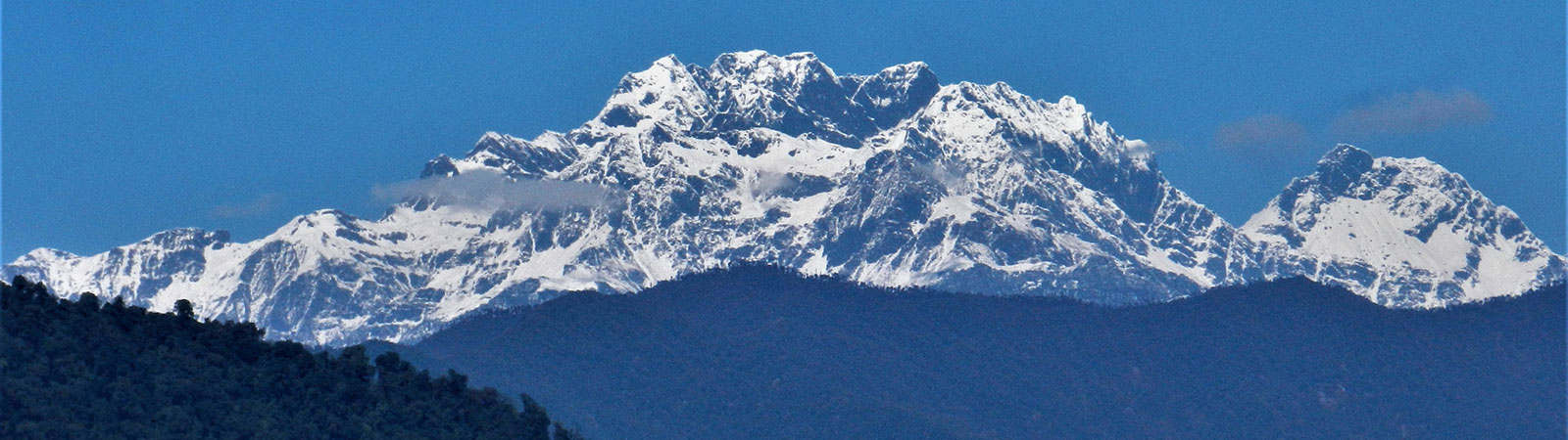
We reached a small settlement at Sangey GG late in the evening and gained access into one of the huts and made ourselves comfortable. The hut had wooden panels with gaps allowing the freezing wind to blow in and chill us to the bone. The morning was a delight as we rushed out to get fantastic views of peaks like Kangto (7022 m), Gori Chen (6488 m), Chomo (6878 m) and Nyegyi Kangsang (6983 m), some of the high peaks of Arunachal Pradesh. To their right, in the far east, the faint outline of Namcha Barwa (7754 m), the eastern limit of the Himalaya, was visible on the horizon. To the west of Kangto were peaks of Tawang, above Gerzila. The historic Sela pass spread out in front of us. With the forest covering the ridges and valleys, it was magical moment. To the west were the hills of Bhutan, thick forest of pines, deodar and many colourful fungi. We soaked in the sun till the afternoon and pitched tents on a ridge to enjoy the evening and possibly the next morning. In hindsight, it was a good decision as it gave us a chance to acclimatize better.
Finally on 13 November 2015, we commenced our trek. On the first day, we followed a long trail to eventually climb up to a high ridge which formed the border with Bhutan. A step across a stone wall and you cross the international border into Bhutan – how civilized! The leading trail traversed wide slopes with the peak of Pema Korsam rising above us. This peak is highly venerated, as from its top one can look across to the Tawang monastery and into Tibet. We passed the hut of a Drokpa (Bhutanese shepherd) at Jobor, the only people we met on the trek. That night we stayed at Nogor (3850 m) near a river. Our three horsemen were mountain people, blessed with a store-house of traditional knowledge and were immensely devout in their faith in nature. Every morning, they would seek blessings for the safety of their horses with incense sticks lit near their saddles, and for the travelling party.
A short walk the next day took us to the banks of the holy Chomjuk lake (4030 m). With white prayer flags fluttering on a small ridge combined with the clear blue waters of the lake, a peaceful atmosphere permeated the surroundings. This lake is worshipped by both Bhutanese and Arunachalis. En route, we also happened to meet a young Rimpoche (head lama) of a monastery in Karnataka, in the south of India, who is a native of Bhutan and was returning from a visit.
Smruthi decided to roam along the shores of the lake, keeping a safe distance from the swamp. Tejas effortlessly climbed to a nearby point to reach a cairn put there. Aarti and Mihir climbed up to a ridge offering an uninterrupted view of the lake. And I, unashamedly, lazed in my tent with my radio and an exquisite view of the lake.
It snowed that night and our trek turned into white snow walk next day onwards. We climbed up to Gyongdong la and traversed a vast valley. There were several lakes, small and large, which we passed en route. There are various routes through this valley with different cols and passes that can be crossed. We chose to follow a straight and short trail ahead. We passed by the Phirapuk camp ground and finally climbed a steep slope to our camp at Merathang (4070 m).
On the 16th, we climbed steeply in bad weather, crossing two vast plateaus lined with fresh snow. Suddenly, the trail crossed a low col, Fongkarpa la (4220 m), and with a descent of 100 m we were on a motor road. This was the same road, still under construction, which joins Sangey GG with Bangajang. We walked two km on the road and camped between two lakes, at Chirigap (4240 m). Next day we continued for eight km, passing Zambala Lartso (lake) and reached Chandezi Lartso at the foot of the Bangajang monastery (4230 m).
Bangajang is a small monastery, situated in a vast valley. There was not a single soul as we spent the day at the monastery. Inside were several Buddhist paintings, thankas and lamps to light. The monks had moved to lower ground for the winter. But these thoughtful monks had left behind enough food and prayer paraphernalia for devotees or visitors stranded in these remote parts. Bangajang is a stone that represents the Tibetan goddess Dorje Lhamo, signifying fertility. This monastery is thus visited by women hoping for a child – they undertake a seven hour kora (circumambulation) on these slopes as an offering. The kora also has many lakes en route and a lama usually accompanies visitors as a guide of sorts.
A taxi picked us up from the monastery on the 18th. We drove for 19 km on the road to Sela pass, crossing Chendre la (4175 m). As we were arriving at the gate of the pass, we could see the narrow valley below, which had witnessed the fierce war between the Garhwal battalion of the Indian army and the Chinese in 1962. Subedar Jaswant Singh fought valiantly against the Chinese army here, holding them long enough to allow the rear forces to be more organized. He was assisted by two Arunachali girls, who were later captured by the Chinese and hanged on a tree nearby. The Subedar was killed in this battle and a memorial dedicated to him has been erected on the main road. This memorial is revered by all in the army and one believes that ill-fortune strikes people who don’t pay their respects.
Back on the road, we drove back to Dirang. Next day, on the way to Bomdila, we had one last view of the mountains and then it was a long drive to the plains and Guwahati for a flight back home.
Members : Bangajang monastery trek : Aarti Mehta, Tejas Mehta, Mihir Gandhi, Smruthi Ranganathan and Harish Kapadia. (November 2015)
Note
Lakshmi Ranganathan had trekked to Bangajang in 2009 (Himalayan Journal, Vol. 66, p. 213). She trekked in October, in better weather conditions than ours. She undertook a day trek from the base at Chomjuk lake to visit Orka lake via Orka la (4072 m) passing Sakteng view point to observe villages in Bhutan. This was in the 650 sq km ‘Sakteng Wildlife Sanctuary’ established in 2002. She also suggested a long high level route to Bangajang from Chomjuk lake. Chomjuk to Sugang (3870 m) crossing two passes Bukchung la (3992 m) and Gyapchung la (4054 m). The following day, one can trek to Luguthem la (3720 m) and Jangachen la (3962 m) to Bangajang.