Holy Takpa Siri mountain
Share on Social
ENIGMATIC TAKPA SIRI: THE HOLY MOUNTAIN
A forgotten High-Altitude Pilgrimage in Tibet
2019
A mountain is simply an inanimate object, a monolithic mass of stone whose size and features inspire awe and admiration. When a mountain is worshipped in any manner it assumes the form of God, the divine. People of all cultures residing in the mountains have their own customs and beliefs surrounding mountains who they consider their giver of life and protector.
Divinity surrounding mountains is the soul of mountain folklore and legends and its inviolability is sanctimonious to all the hill people. Some of them believe in enduring physical hardships, a kora; a process of circumambulation around holy mountains. This they believe, is a means of expressing their closeness to God and in the process invoke deep faith residing in them.
Tibetans and Buddhists are intensely religious and are deeply convinced about existence of deities in all the lofty mountains and sacred lakes in Tibet. They frequently engage in performing a kora(circumambulation) which is an integral part of their spiritual life and the most direct way to engage in an inner dialogue. They believe in the power entrusted in these invisible deities to protect and safeguard all life on earth. A handful of mountains are considered special and are major religious symbols. Takpa Siri peak is one that ranks high alongside many well-known ones.
By Himalayan standards, Takpa Siri is a small mountain. At 5735 m (18,815 ft), it is lost in a maze of peaks and thick forests along its border. But it stands tall in terms of spiritual significance to the Tibetans and many Buddhists across the border. It is imperative for them to undertake an arduous pilgrimage around it at least once in their lifetime. F. M. Bailey, the British explorer completed a kora around the peak in 1913. He wrote
The mountain round which the Short Pilgrimage (called Kingkor) ran was an 18,000-foot peak called Takpa Siri. Its choice as a holy place seemed to me an excellent example of human economy. If it had remained profane, life would have been on a far lower level. Sanctification was the greatest asset it possessed.
Though I made enquiries, I could find no reason why it should be regarded as holy, except the legend which Kinthup reported that goddess Drolma used to pasture cattle at Kandrotang on the banks of a mountain lake called Potrang lake.
Perhaps the real reason for its being regarded as holy was that it was a savage place, unfriendly to man. Human beings in their pursuit of the infinite can seldom resist the lure of the merely uncomfortable. Or so it seemed to me, as I did the circuit at a speed which no doubt was too rapid for the full acquisition of merit.
F.M Bailey, No Passport to Tibet, p. 205
Takpa Siri is a massive ridge running east to west approximately 20 kilometres north of the village Taksing, situated on the Subansiri River. At the base of the ridge and close to Keju la, lies a small lake called Purang or Potrang. The lake and the ridge are both considered sacred by the Tibetans, and a yearly pilgrimage called Kingkor is made around the ridge between July to September.
As per Tibetan belief, a mountain with four hills/passes and four water bodies is considered sacred. Takpa Siri ridge consists of four hills/passes and is hence called ‘Rejincey’. The passes are Keju la, Sangyo la (Kangyo la), Sagam la and Chuma la (Longju). Similarly, the four water bodies, or the ‘Chujincy’, is formed by Yume chu in the west, Tsari chu in the north, Hembrang chu in the east and Taktsang chu in the south. There are three lakes. Purang or Potrang is called the ‘Husband’ lake, Kyomu is called the ‘Wife’ lake and Umbare is called the ‘Son’ lake. Out of the three Potrang or Husband lake is considered most sacred and is worshipped by pilgrims from all over Tibet. Female worshippers can go around the Kyomu Lake only.
Hundreds of pilgrims from Tibet, Bhutan and even far away Nepal visit the “Holy Mountain”. To accumulate merit, they are required to go around the mountain which itself is a challenging proposition. Many have lost their lives.
It is a unique expression of faith. It is believed that personal transformations take place in the pilgrim. By facing dangers and hardships with devotion, they attain heroic status, and are to be highly respected when they reach home. A sinner stands purified and for those seeking death, it allows one passage to heaven, akin to the Hindus wanting to give up life at Varanasi. One Tsari Ringkor is considered sufficient to wash off all past sins. Tibetans joke that Ringkor of Takpa Siri was so popular with groups of well-armed, rough-and-ready Khampas because they all had murders or battle-deaths on their conscience for which they sought purification; provided there was no fight with Lopas on the trail!
Strangely, due to the close proximity of the kora to the mountain, the peak of Takpa Siri is never visible fully while on the kora. You can sense its presence but never physically see it, like the omnipresent Buddha. Even when walking away from the mountain, the trail plunges into the valley with only a small portion of the Takpa Siri ridge visible. In the south, in Arunachal, thick forests, deep valleys, rain and fog ensure that the peak is well hidden to entail it the enigma, aura and the mysterious legends that simple Tibetans attribute to it.
Kingkor
Kingkor, called ‘Lunger’ by the locals, is a yearly shorter pilgrimage, which is undertaken by men only. It involves a smaller circuit around the Takpa Siri, near its base, along the track; Chickchar, Mipa, Sagam la, Tamlangonga to Potrang. The return route is via Tumdan, Chakta Changu, Karkyu la to Yume.
Pundit Kinthup, during his exploration of the falls on Tsangpo River, undertook a circuit of this Holy Mountain. He writes that women were forbidden from undertaking this kora because a woman was known to have incurred the displeasure of the residing Goddess Dolma. Goddess Dolma once, lay across the path at summit of the pass. As a man approached her, she told him, “I am so weak that I cannot move. If you have pity on me, find another road. If not cross over me”. The man chose to take a different road. A little while later, a woman approached and asked to be allowed to pass. The goddess posed the same plea to her as well, but the woman crossed over her and went on, hence earning her wrath. Then on they are permitted to go exactly seven steps beyond the pass called “Dolma La”.
Bailey asked a monk at Tsari whether he had heard the legend.
“Well”, said the monk, “you know as well as I do, wherever there are women, there is trouble. The reader can choose whichever version he prefers; or both. They are not inconsistent. After all, the behaviour of the goddess Drolma is only an example of the monk’s general principle”. (Bailey, p. 206.)
F.M. Baily and H.T, Morshead, two British army officers, were deputed in 1913 to traverse the India-Tibet boundary from north. Based on their detailed notes and survey the McMahon Line, demarcation of boundary between Tibet and Arunachal Pradesh, was drawn. When they arrived at Chosam at foot of Takpa Siri, Morshead remained busy with survey while Bailey undertook the shorter kora, the Kingkor. It is fortuitous for history that he recorded his pilgrimage in detail and wrote about his personal experiences.
The pilgrimage, starting from the Tsari drainage at Chikchar, climbs up five miles to the Tsukang (resting camp) called La Pu. Then the trail leads to the top of Dolma La (16,100 ft) and on the other side, the stay is at Mipa. Next day the Potrang Lake can be reached. It was here that Goddess Dolma grazed yaks, below the Sagam pass. There were Tsukangs at regular intervals and caretakers used to manage these resting places, by storing wood and rice for the pilgrims. They stayed there between March to August, until the trail was maggot infested in later months and the pilgrimage stopped as it was sacrilegious for a pilgrim to walk over a maggot, a living creature. Tsukang keepers then went home to their villages with offerings. They collected poppy seeds, dwarf rhododendrons, and many medicinal plants. Pilgrims gifted them swords, gold coins and cloth which they later sold at Tawang.[1]
At the Potrang Lake (called “Podrang Yumtso”- Turquois Lake) accompanying Ula (porters) from Chickchar went around the lake and collected poppy seeds for the Tibetan doctors before handing over the loads to the fresh Ula who had come from Chosam and Yume. Turning north, Bailey passed Dorje Phagmo Lake. He mentions: “Pilgrim had taken 5 days over what had taken me three; no doubt because he had found spiritual ease where I had found only physical discomfort.” [2]
From Potrang the trail travelled to Tomstang, fairly at a flat level behind a tall wall and the main face of the mountain. Bailey was surprised to find this sacred region devoid of wildlife and birds. “I suppose safety has a ceiling price and the creatures which had not yet evolved a religion preferred a little danger to that awful damp and rain.” Bailey had now completed the “male only” section of the pilgrimage and the trail turned to the west, towards the Yume drainage. Bailey reached Yume the first village of twelve houses; “And what a welcome site it was, first village after four days from Chikchar. It had a large temple tended by four Monks. Civilisation is relative term and Yume was a synonym for it that day.”
Bailey reached the Yume Gompa which contained a figure of Dorje Phagmo. Bailey was impressed, he writes, “but perhaps this was merely because it was something made with human skill in a building fashioned by man towards his own vision of God. It was such a relief after the desolation of the sacred mountain, unseen by the pilgrims.” (p. 209) Only a few evolved souls can feel the presences of unseen Takpa Siri. For others this figure was enlightening, as Dorje Phagmo is the ‘Sow incarnate’. (A person who embodies in the flesh a deity, spirit, or quality) was the only female incarnation in Tibet and is very holy.” Dorje Phagmo, is considered as figure of Dolma. (Italics mine)
The old temple at Yume was burnt down in 1906 by Lopa, Arunachal tribal raiders. It seems that Lopas came to Sanga Choling, a large monastery, to sell forest products. But that affected the trade of Tibetans of Tsona and there was a skirmish. Next year, the Lopas attacked Yume monastery and burnt it. The Tibetan government sent 500 soldiers from nearby Guru Namgay monastery and they pursued the Lopas. Few were caught but the rest went down the valley to Taksing. Even the soldiers, riding horses, found the forest intimidating and did not go down the valley after them.
Continuing further Bailey completed the Kingkor at Sanga Choling, a large monastery and village. He linked up his survey notes from Chickchar with Sanga Choling watershed. This was also the junction with Ringkor pilgrimage, a longer Pilgrimage, performed every 12 years. He met his companion Morshead and both proceeded to Tsona on the Chayul Chu (Subansiri river).
Ringkor
Ringkor, called ‘Logar’ by the locals of Taksing, is the longer kora with a frequency of once in 12 years. People from all over Tibet whether men or women undertake this pilgrimage. It had the direct patronage of the Tibetan Government (major pilgrimage stopped after the fall of Lhasa in 1950) and an official from Lhasa always accompanied groups from aristocratic families. Government officials collected taxes and goods from all Tibetans villages en route. The last known Ringkor was in 1959. From 1980 the Chinese allowed all pilgrimages again in the Tsari except Ringkor as part of the trail is now controlled by India.
The route they followed was Chosam, Tsari chu, Longju, (from here it enters Indian territories) Maja, Bidak, Gelemo, Gelensiniak and along Subansiri to Taksing and thence to Yume in Tibet. Pilgrims undertaking the Ringkor were afraid to enter the Tagin areas of the Subansiri valley, as the local tribal would set traps and loot them en route. Their poisoned arrows and the thick forests had already killed many Tibetans. As a result, they resorted to buying protection and guides from the Tagins by the way of 13 yaks, 50 Dao (Dah), 108 Muni (bead necklaces) and food grains. Gifts included jewellery, woollen cloth, white Yak tail and most prized items were those made of metal: long and swords, metal bowls, bells and cymbals.[3]
The pilgrims used to gather at Tsari in large numbers, local villagers called Tsariwa, looked after their needs. The trail ahead descended along the Tsari River deep into the Lopa country (now Arunachal Pradesh). It was well organised and elaborate rituals were followed.
By November over 100 yak loads of supplies would be transported to the south from “Tsari Mandala plain”, past the Tsari valley and Chikchar along the river to the confluence at “Phodzo Sumdo”, which literally means “where Tibet ends”. The river drops steeply to “Loyul”, the Lopa country, at start of 150 km trail to Yume and Chosam.
On the appointed day, the dress of Dalai Lama, a symbolic gesture as the religious head, arrived at the “Mandala Plain” signalling the commencement of the pilgrimage from the village of Migyitun. After rituals two lamas would lead the way; “Gangshak” (snow-cutter) and “Gangten” (snow-firmer). Pilgrims would depart daily in smaller groups over the next 6 days; camps and food supplies went with each group. Though tributes were paid, a contingent of armed Tibetan soldiers went with each group to protect against any sudden tribal attacks. “Tsedrung” from Lhasa was a lay official who paid tributes to all villages en route in the Lopa country.
They descended along the Tsari chu till it met the Subansiri river. Then trail turned west to follow the river to Taksing village. More food and supplies were sent from Tibet along the Char River as pilgrims would wait at Doring Rest House. Despite the orderly conduct, sometimes conflict between the Tibetans and Lopas arose and few people would die.
Towards the end of the pilgrim’s passage through the Lopa country, a feast was held at Doring and the pilgrims would divide into two groups. Those from the western Tibet, Bhutan and Nepal would follow the flat Subansiri River and go up along the Char river, in “Chayul”, to the huge monastery of Sanga Choling. After ceremonies the pilgrimage ended, and they would disperse. The other group would turn north along the Yume river to cross Ribba La and complete their circuit at Yume Gompa at Chosam.
The War
The pilgrimage continued until the Communist Revolution in China reached Tibet in 1953. Tibet was annexed by the Chinese and pilgrimages were stopped. In 1959. Dalai Lama entered India from Tawang. The Indo-China war of 1962 witnessed heavy military action on this route. India, under its doctrine of “Forward Policy”, had built an army post at Longju, overlooking Migyitun and Tsari area. This was resented by the Chinese and as the war started, Longju post was one of first ones to be wiped out. Chinese soldiers poured down the Tsari valley to reach Limikang.
In the west, overlooking the pilgrim route to Lung and Char major conflicts occurred at Asaphila during the war, and continued for several years intermittently. Thus, from both sides this was the end of the tradition of pilgrimage.
The McMahon Line, which demarcated the boundaries between Tibet and the NEFA (Arunachal Pradesh) had special considerations in the area of Takpa Siri. The line defined the boundary just south of Migyitun. Both Lopas and Tibetans had trading rights and ownership of land on either side. But the major consideration was the Takpa Siri’s Ringkor pilgrimage route, which crossed both areas. It was agreed that line should be further adjusted to accept religious traditions of the Tibetans at Migyitun. Nothing was done as political climate between the two nations deteriorated rapidly. Both sides prohibited crossing of the border and this was curtains down on a fine tradition. Chinese opened the area for Kingkor in 1980 and Tibetans were allowed to perform the shorter kora.[4]
Some early travellers undertook parts of the Takpa Siri pilgrimage. F. Kingdon-Ward, the famous botanist who studied the forests of Tibet and Burma, visited this area and has written about its flora. F. Ludlow, another botanist, followed in his footsteps followed by F. M. Bailey with H. T. Morshead. One of the earliest pilgrims was Kinthup who while searching for the Tsangpo Falls made a pilgrimage here.[5] In October 2005, four of us undertook the “Half Ringkor” on the Indian side. On the east, the trail followed along the Tsari Chu from place of an old Tsukang at Gelensiniak, till Maja, last point on the McMahon Line. While on the west we followed the Subansiri river upstream to Taksing. [6] But, since the trail was deep in the valley, Takpa Siri was never revealed. [7]
Goddess Reveals
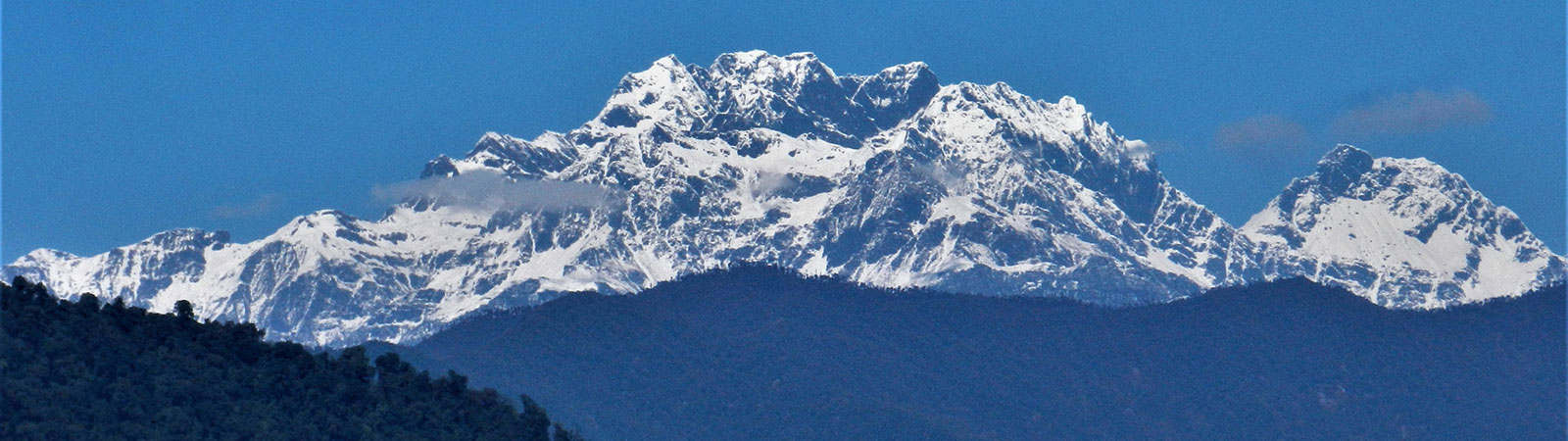
South of the Subansiri watershed, forested valleys feed the Kumey river (Kamala River). Studying the maps, it seemed possible that the Holy Mountain can be viewed from one of the high ridges of the Kamala valley. But there were no roads, thick forest and clouds, which cover most of the Arunachal valleys, were a problem. In 2018, with hope and prayer we reached the Kamala after a long drive and crossed the ridge between the Khru and the Kamala. At first, thick forest cover allowed no views. But on the second day, not too far down, we camped on an army Helicopter ground. They had cleared the forest for the machine to land.
As the clouds lifted in the morning sun, the Holy Mountain, Takpa Siri, was visible due north. The close-ups showed terrain of the Kingkor, Dolma La pass, Potrang lake and walls. Every aspect facing the south was clearly visible.[8]
A long correspondence with a Tibetan friend, Awang at Lhasa, yielded some pictures of the northern aspects of the mountain. He had undertaken the Kingkor in recent times and made special efforts to photograph the mountain.
The search for a religiously significant region like Takpa Siri is rather a spiritual endeavor than just an area survey. Its mystical attributes coupled with powerful natural phenomena like unseen mountains is bound to invoke supernatural feelings. The mountain, irrespective of whether viewed or captured digitally will continue to retain it aura and legacy and be worshipped for generations to come.
More references:
Keith Dowman: The Sacred Life of Tibet. Harper Collins Publishers Ltd., New York, 1997
Victor Chan: Tibet Handbook – A Pilgrimage Guide. Moon Publications, Chico CA, 1994
Summary:
Recalling a forgotten circumambulation trail around the holy mountain of Takpa Siri, on the border of Tibet and Arunachal Pradesh.
[1] F.M. Bailey describes the Kingkor pilgrimage route in his book. (Bailey, F. M., Lt. Col.: No Passport to Tibet. Rupert Hart-Davis, London, 1957. (P. 205-210)
[2] Something to note for modern-day trekkers and climbers indulging in rush tactics!
[3] Full details of the Ringkor pilgrimage is given by Toni Huber; The Cult of Pure Crystal Mountain. Oxford University Press, New York, 1999. Pp. 108-151.
[4] Lamb, Alastair: The McMahon Line, two volumes. Routledge & Kegan Paul, London, 1966, p. 322/23 and 537
[5] Ludlow, F. : ‘The Sources of the Subansiri and Siyom’, HJ Vol. X, p. 1
[6] Kapadia, Harish: ‘Secrets of Subansiri’, HJ Vol 62, p. 68
[7] A defence road is built along the Subansiri river, obliterating the ancient pilgrim trail completely.
[8] “The Unknown Kamala Valley” by Harish Kapadia, the Himalayan Journal (Vol. 74)