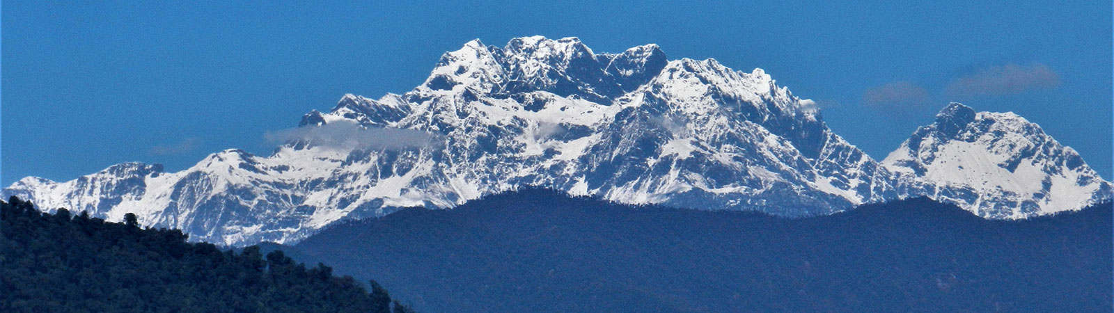
Holy Takpa Siri mountain
Share on Social
THE UNKNOWN KAMALA VALLEY
Exploring the Kurung-Kumey valleys in Arunachal Pradesh
2019
Sources of ideas for a trek are many. The usual culprits being a book, a talk or an article suggesting a new area, or perhaps the distant view of a mountain one has seen. But some can be strange, for instance, while travelling by road on the way to the Tsangpo valley, at Yazali, I saw a small road sign indicating “Koloriang -157 km”. The driver mentioned that it takes a day to reach there, provided the road was functional that day. After consulting maps, I later deduced that this road goes along the Kurung (or Khru) valley. The Kurung merges with the Kumey to form the Kamala, a major tributary of the Subansiri River. Like a beautiful face launching a thousand dreams, this road sign sprung a deep desire to explore these areas.
In 2008, while visiting Ziro, on the Apatani plateau, we undertook a 3-day trek to the Tale valley. Through thick forests, we could see some fascinating views of high mountains beyond.[1] This was the final push to concretise my plans for a trip to the newly formed Kurung-Kumey District, with its headquarter at Koloriang, and the area around the Kamala (Kumey) and Kurung (Khru) which are a part of it.[2]
The Kamala originates from the snow ranges in the north. Later, the Kurung, another snow-fed river merges with it.
A rough road along the Kurung valley exists in the south, but the remote Kamala valley has no road connection. Currently, there are three road approaches into the Kamala valley from the road in the Kurung valley. A road from Yangtse to Tali is being built, while Koloriang to Parsi-Parlo is in operation, and the road from Koloriang to Sarli and Damin is only partly ready.
MIRI MISSION – 1911- 1912
The Apatani plateau and the Kamala valley came to the attention of the British in 1911.
The British regularly sent exploratory teams, called “Missions” to survey areas in unknown valleys. Miri Missions in 1911 and 1912 reached the Kurung valley and crossed into the Kamala to the village Tali. At Riang, they were attacked, but with superior firing power, they overpowered the tribesmen. Authority was gradually established in the Kurung and Kamala valleys over the next decade.
At the Shimla Conference in 1914, the McMahon Line was drawn that settled the boundary between India and China. The focus of the government then shifted further north to the Subansiri area. The Kurung and Kamala valleys were now under the British administration and were administered from new township of Koloriang. [3]
It was intended that the Miri Mission proceed north into the Subansiri valley. But the hostile attitude of the tribesmen forced the Mission back, long before they reached the Tibetan border. Furthermore, with information provided by F M Bailey, Sir Henry McMahon, then the Defence Secretary seems to have drawn the line south of Migyitun as boundary of Tibet with the understanding that some small modifications might have to be made to meet the Tibetan religious susceptibilities.
Christoph von Furer-Haimendorf
In 1944, German anthropologist Christoph von Furer-Haimendorf made a foray into the Kamala valley from the east. He crossed the Kamala on rafts as a bridge was washed out. He reached village Dobom and climbed to a height of 4000 feet to view high peaks in the north. He wondered though, if these peaks were part of the main range of the Himalaya or located on the ridge separating the Kamala from the Subansiri. He proceeded to the junction of the Kamala and Selu River, a tributary of the Kamala and reached the village Tali.
Nearby, was the prominent peak of “Pij Cholo”. In the thick forest, a high prominence with rocks and devoid of trees was looked at with wonder. Haimendorf proceeded slowly up the Kamala and stayed at many villages to complete his anthropological studies. These are well recorded in his book and are pioneering reference to these valleys. After 6 weeks in the Kamala valley, he returned to North Lakhimpur in the plains of Assam. He had spent eight months in the valley establishing an external governing authority in the valley for the first time, especially the Apatani plateau. [4]
Col. F.N. Brett and Ursula Graham-Bower
Subsequently, an ‘Inner Line’ was set up by the British to prevent outsiders from entering the tribal area and proceeding towards Tibet.
After Haimendorf left the valley in 1945, a British administrator F. N. Brett was deputed there in 1946. He was the Political Officer of the then Subansiri Frontier Tract. He was accompanied by his anthropologist wife Ursula Brett (formerly Ursula Graham Bower), who studied the life style of the Apatanis and recorded it in various journals and a book.[5] Col Brett started making plans to extend the British Administration over these valleys. They explored areas south of the Kamala valley, along the Kurung and Panior Rivers.
After Col. Brett and his team left the valley, a platoon of Assam Rifles, supplied by air, was permanently stationed at Hapoli (premises still exist), This was the time when the World War II had just ended, and the military was very much in command in the North-East.
Tarun Kumar Bhattacharjee
Tarun Kumar Bhattacharjee, was an Indian administrator who spent almost an entire life time, working in the remote valleys of Arunachal Pradesh. He pushed into the far-flung valleys to meet the villagers, and this was one of first contacts these people had had with Indian administrators. Being a person of authority, he travelled light obtaining supplies and porters locally. His treks were long and arduous. It was definitely his own enthusiasm above his official duty that carried him to these remote places. Luckily, he was a writer and has written many books about his travels that form an invaluable reference of that period.
In 1960s, he was the first Indian explorer of the Kamala valley, after Haimendorf and Brett. Entering the Kamala valley from the east, near where it merges with the Subansiri, he went west, almost along the river. He spent time at villages to understand their problems and establish administration. He trekked to Tali, Parsi-Parlo, Damin and after crossing the Kamala, reached Huri. He has written about people, their legends, and beliefs about the views of snow peaks. After reaching Huri he returned via Damin to Koloriang in the Kurung valley to reach Ziro, the administrative headquarter.
His observations were detailed and experiences unique. He passed a bridge, nick- named as “Murkong Koro” literally “Money Eater” bridge. A cash escort party, carrying huge pile of cash, rested near this bridge. They gambled to pass time. A person who lost heavily, next day volunteered to carry the heavy cash box. He managed to steal cash and show that the box had fallen into the river while crossing the bridge. His trick was exposed later by the visit of Bhattacharjee and he was arrested.
Bhattacharjee saw a tunnel in the forest called “Buru Jiyan”. As per legends, it was 12 km long and built by a tribe called “Mire”. The tribe had long since vanished but was believed that their spirits roamed in this tunnel.
He talks about a Tongue-less Tibetan bell, called “Maji” a pride possession of the locals, which they were known to display only in the most pressing of situations and certainly something they would never part with. They also had “Binam Talo” a rare metal plate. In an area where metal and even rocks are at a premium, these were prized possessions.
In 1896, a government official, a Hill Miri contractor, was murdered here. To punish the villagers, troops under the command of Captain McCabe was sent in 1897. Locals were no match for them and surrendered immediately. As part of the final settlement the British were given three Mithuns, the Tongue-less bell and the rare metal plate. The troops were unable to control the Mithuns, so they carried only the other two items with them. Their location or existence till date is unknown.
Bhattacharjee, T. K. was certainly an unsung hero and his dedicated exploration must be admired. It was not only here but in many such valleys of Arunachal Pradesh he performed his duty as if he was born to do it. His four books are a treasure trove on which current administration is built.[6]
MOUNTANEERING EXPEDITIONS
There have been two mountaineering expeditions to the high peaks northwest of the Kamala valley.
The first team to visit the area was from the Indian Mountaineering Foundation in 1995, led by Col. M.P. Yadav. They travelled to Koloriang, Sarli and went further northeast via Milli towards their desired peak, Nyegi Kangsang (6983 m). They solved the terrain difficulties and reached the high col to southeast of the peak. Crossing to the north, they made a final camp. However, their summit attempt stopped on a plateau below the main summit.[7]
In 1999, an Indian-British expedition was organised to this valley, led by Col Balwant Sandhu and Doug Scott. The team was delayed by poor roads to Koloriang and further to Sarli. They had administrative problems and lack of enough porters. They proceeded to Milli along the Kurung valley, proceeding north towards “Takpa Siri” peak (6657 m) in the range. Unfortunately, this peak wasn’t the same as the one worshipped by the Tibetans, which is only 5735 m, rising above the Subansiri valley. This party endured much suffering, literally, sickness to injuries and attacks of malaria. Eventually, they had to be evacuated by helicopter having managed to obtain only a faraway glimpse of their peak.[8]
Our 2018 Trip
On 14 November 2018 we reached Ziro, via Guwahati and Naharlagun. We started for Koloriang in a taxi on the 18th. There are good roads, bad roads and this was the worst road! After just few kilometres on the road, we hit pot-holes and slushy mud, especially after recent rains.
We continued passing various small villages, road maker’s camps and bridges across Panior and Kurung Rivers at different places. A major road bifurcated to Nyapin, to the southwest, from Sangram. By late evening, we were settled down at the ‘Circuit House’ of Koloriang. Next day, we looked around the lovely valley, the Church and the houses spread over.
Ahead we drove to Sarli, a quaint village to the west, in the upper Kurung valley. The next morning offered us magnificent views of the high mountains on the Tibetan border. They were all just unknown “Peak and Metres” mentioned on the maps. Two passes in this range, Jammu La and Mukpa La are well guarded by regular patrols. This area had not witnessed any skirmishes with Chinese forces during the 1962 bloody war. From Sarli, a newly built road climbs up steeply, though the vast and expansive forest. It was a pleasure, when we reached the “Phurchi Top (2434 m). We now entered the valley of the Kumey River, which is called the Kamala River once it is joined by the Kurung River beyond Palin in the east.
The road descending to the Kamala valley was still under construction full of mud and rock at places, and vehicles being able to go up to “Kilometre 39”. As the road progressed, stages were noted by distance simply mentioned as “KM 39” or “Kilo 39”. We came at the roadhead at a small curve in the road and camped. Ahead we had to trek through thick forest.
The Trek
Next few days we were to experience thick jungle and bad trails. The trail descended to a side valley and after a steep and muddy crossing, a rough road reached KM 44. This was a great camping ground, literally on a helipad. We were looking at a vast panorama, with the Kamala valley cutting across at the bottom. Of the peaks seen, almost due north to us, was the real “Takpa Siri” peak- the holy mountain. At 5735 m it is small by the Himalayan standards, covered by ridges and forest. As the area mostly remains under thick cloud cover, this was a rare view. Such a full and frontal view of this historic peak is difficult to obtain easily as the pilgrim routes around it pass too close to the peak or through deep valleys. (See article. “Enigma of Takpa Siri” in this Journal).
Damin
On the 23rd November we left the Helipad Camp early, as the route was long, almost 17 km. We were walking on, what is locally known as the “cutting road”. The road has been cut through forest, widened but unfit for vehicles. There were no camping places en route. The trail was going all the way down, which assisted us. Our first companion was a person carrying a heavy load, of Pepsi Cola bottles! Apparently, in these faraway villages, even on the banks of the pristine Kumey River, people are accustomed to drink Pepsi Cola when thirsty! This was something way beyond our comprehension. In fact, even single hut restaurants seemed to have colas available. And the dumping areas next to the huts were inundated with used bottles and empty cans which of course are going to be untouched for decades. This is a grave disaster waiting to explode.
There were many young boys and girls climbing up from Damin, KM 61 to KM 39, where they had parked cars. A camp was on at Damin to register and check voter identification for voting in the Indian elections. It was amazing to see the zeal to vote. But soon the reason was clear. Each voter was assured of lump sum money on voting by the paying party. As bonanza for voting favourably, a family can easily rake in a free car in exchange for about 5 to 7 family votes. Voters remain truthful to the cash giving party, even though the voting is confidential. People here are honest!
We reached Damin quite late. It was a large village, spread over at two levels. Opposite Damin, across the Kamala valley, was a prominent rocky projection called “Tolo Domcho”. It was a curious shape and stood out distinctly between the thick forest. Such projections, like “Pij Cholo” near Tali, are associated with legends. It is believed that during a solar eclipse, souls of dead people of the long-lost Mire tribe emerge from the tunnel near Darpai and roam here. The pinnacle is clearly seen from Damin and it rises from the plateau behind Huri.
Damin to Huri (KM 71) was about 10 km. Trail descended steeply to the right bank of the Kamala. After few kilometres we crossed the river on a long Foot Suspension Bridge, made out on bamboo footboards, supported by strong steel wires. On the other bank the trail started climbing immediately and went on relentlessly for few kilometres. We reached the middle ridge where the ITBP (Indo-Tibet Border Police) camp was located and were shown a hut where we settled down, to stay two nights.
Huri
Huri is a beautiful place, almost like a hill station. It was a long ridge without any forest, a helipad at its end and the Huri village beyond. The Kamala River descending from the northern mountains and its entire catchment area were visible. Ahead of Huri in the Kamala valley, there is only one village Ruba. From Huri, Taksing, almost on the Tibetan border, was 60 km, five stages, across a high ridge to the north. Located on the bank of the Subansiri River it is well-known village in the valley.
People of Huri are known for their aggression. In the late fifties, the Political Interpreter (a government post) of Tali was brutally murdered at Huri, by one Sathe Talar. The Government sent a platoon of Assam Rifles under Commander Picha Kati to punish him. Picha Kati was ambushed and captured by Talar and killed after extreme torture. The government initiated a strong action and managed to capture Sathe Talar.
He was imprisoned and heavily guarded, but taking advantage of drop in vigilance, he managed to escape and remained fugitive for many years. Later, his relatives paid a heavy compensation to the family of the deceased following which Talar was allowed to return to the village and the case was officially closed. In spite of this, relationship between Huri and Tali continued to remain tense.
Tarun Kumar Bhattacharjee met this legendry fugitive many decades later, when he was then headman of Huri. He writes “Though mellowed by age, yet I was struck by his confident attitude even though he was a convicted person.” [9]
Return along the Kamala
We started our return trek from Huri on 26th Nov. We descended from Huri to cross the FSB and trekked along the Kumey (Kamala) on its right bank and avoided climbing up to the main village of Damin.
We were to trek to Parsi Parlo village, about 30 km away through thick jungle. It was a narrow trail with many ups and down. As we proceeded, the faint trail became particularly challenging and climbed a little. We made two camps en route. On the third day, behold, – we suddenly came across road building machinery with a car standing at a little distance. The trek was over, so we thought. But there is always a twist in the tale, our walk on the rough road continued for 13 km, past a large village Pagam.
On the 30th we passed Atung and finally walked into Parsi Parlo, a village between two rivers Parsi and Parlo. Here, we managed to arrange a taxi for ourselves on the 1st December. We crossed to the Kurung valley from Totam Pass and joined the main road. It was dark when we approached Ziro and the headlights of the taxi went burst. Luckily, a helpful car drove ahead of us to make our journey little easy to a home stay at Ziro.
The trip was over, and we enjoyed a hot bath and food. We hired a vehicle to reach the Naharlagun railway station, a few hours away. As we passed Yazali, we now knew what was ahead of that road sign “Koloriang 157 km”.
Summary
A trek in the remote Kamala valley, (Khru and Kumey river valleys). Crossing into the Kumey from Khru the party explored various peaks, including the evasive and legendary Takpa Siri (5735 m). They returned along the Kamala and crossing back to the Khru.
Dates: 13th November to 5th December 2018
Members: Harish Kapadia, Wing Commander C M Jaywant (Retd.) and Group Capt. Nitin Kanitkar (Retd.)
[1] Kapadia. Harish; “On the Apatani plateau, the Subansiri valley, Himalayan Journal, Vol. 73, p. 136
[2] Bose, M.L.: History of Arunachal Pradesh. Concept Publishing, New Delhi, 1997. P. 121, 128 and 148.
[3] Lamb, Alastair: The McMahon Line, two volumes. Routledge & Kegan Paul, London, 1966, p. 322/23 and 537
[4] Furer-Haimendorf, Christoph von: Himalayan Barbary. Reprint: Spectrum Publications, Guwahati, 2016 (First Edition, 1956). Pages 183 to 200 “Kamala valley”.
[5] Ursula Graham-Bower: The Hidden Land, 1953, Reprint; Allied Publishers, New Delhi, 1978. See Chapter 7, p. 67 “To the North” trek in the Kamala Valley.
[6] Bhattacharjee, Tarun Kumar: His Books: Enticing Frontiers; Alluring Frontiers; Frontier Trail and Idus of Mathun and Dri valleys
[7] Yadav, M. P. (Colonel) “To Nyegi Kangsang”, Himalayan Journal, Vol. 52, p.9
[8] Scott, Doug, “Arunachal Pradesh”, Alpine Journal, London 2001, p. 59
[9] Bhattacharjee, Tarun Kumar: Enticing Frontiers. Treks in the Kamala and Khru valley between 1968 – 1972. Page 43 to 78.