Holy Takpa Siri mountain
Share on Social
ARUNACHAL PRADESH – THE LAND OF RISING SUN
2014
The problem of the tribal area is to make the people feel that they have perfect freedom to live their own lives and to develop according to their wishes and genius. India to them should signify not only a protecting force but a liberating one. Any conception that India is ruling them and that they are ruled, or that customs and habits with which they are unfamiliar are going to be imposed upon them, will alienate them.
Jawaharlal Nehru
In his famous poem1, the Indian bard Iqbal sang praise of the Himalaya. He called it an impassable barrier and its high peaks as protector of the country. Indians were brought up with a belief that no enemy can do harm across the Himalayan chain. This belief was shattered as the Chinese army cut across the Himalayan chain in 1962 in Arunachal Pradesh and Ladakh. The high peaks, lush forest and hilly terrain did not stop the enemy. Indians had to think again about the impregnability of the Himalayan chain.
Arunachal Pradesh was earlier known as North East Frontier Agency, or NEFA for short. Many hostile tribes lived in the thick forest, so thick that administrators were not inclined to enter the areas and face the tribal chiefs. Except on the foothills close to Assam very little was known of interiors of this state. The tribes lived within their areas and were self-sufficient. For their other needs like salt they had relations with Tibet.
Mountains
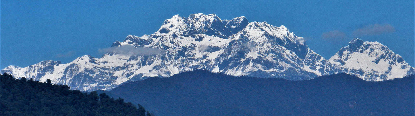
Arunachal Pradesh from the border of Bhutan till Tsangpo (Brahamaputra) gorge, where it enters India, is the easternmost part of the Indian Himalayan range. It was earlier classified as the ‘Assam Himalaya’. Most high peaks here lie on the McMahon Line, the international border, or little to the south of it. The valleys towards north across the border are flat leading to the Tibetan plains while valleys to the south fall steeply towards India into thick forest of Arunachal Pradesh. Some of the well-known peaks are Gorichen group – a group of six peaks, Kangto 7,042 m, Unnamed peak around 6,400 m, and Nyegi Kangsang 6983 m.
The only mountaineer to visit the Arunachal Pradesh before the World War II was H. W. Tilman in 1938. Ironically he wanted to remain, what he called, ‘nearer to civilisation’, if called upon by the British army to serve. Accompanied by four Sherpas, Tilman walked from Tipi2 to Bomdila through thick forest in the humid month of April. They crossed Bomdila and reaching Thembang followed the Bailey Trail in reverse. He crossed the famous pass of Poshing La, but missed all the views due to fog, a constant problem in Arunachal. As he went around suddenly one of his Sherpa died of malaria. Tilman himself suffered severely from regular bouts of malarial fever. He and the remaining Sherpas forced themselves back across Poshing La, which was at that time snow-bound. From Thembag they were carried on horses and helped by the British Government to reach civilisation. They barely survived.3
Not much climbing has taken place since then. Gorichen II (6,488) was first climbed in 1966 by an Indian army team. It was easier, though more expensive and administratively difficult, to climb peaks from the Tibetan plateau. The Japanese climbed peak Kangto in 1988, approaching it from the north. Nyegi Kangsang (6,983 m) was attempted in 1995 by a team from Indian Mountaineering Foundation, which mistakenly claimed an ascent. On the latest maps, Kangto (locally known as Sher Kangri, the ‘eastern mountain’) is 7,042 m and stands as the highest peak in Arunachal Pradesh (and on the McMahon Line) and the only peak above 7,000 m in the eastern Indian Himalaya, east of Bhutan. The Himalayan range east of the Tsangpo gorge, where it enters India, peters out into smaller
Tribes and Religion
Arunachal tribes were independent for centuries. It took a long time to integrate them with modern ways. There are so many tribes and with so much tradition that it needed to be preserved. But like many things, these traditions have all but disappeared. Some traditions are well respected even today. For e.g. once every year a goat is declared as the consort of Gods, Jhum Raja, the king who is free to roam anywhere. He can literally enter any field and eat what he likes with consent of Gods, so no one will touch him. As a result he grows fat. The villagers have a saying: ’how long can the mother of a goat smile? One day his son will be sacrificed’. Soon he is offered to Gods and the villagers have a feast.
In one tradition of ‘Donyi-Polo’ (the Sun and Moon Gods) religion, villagers erect eerie looking bamboo structures at prominent places with eagle and other birds hanging on it. These are funeral towers erected on recent graves and the birds are said to carry the soul to heaven. It is considered an ill omen to go too near it. After few months, a permanent solid rock grave is engraved here.
Such traditions, culture and tribal life of Arunachal Pradesh, were studied by Verrier Elwin, a well-known and devoted anthropologist who worked amongst the tribes. His studies were legendary and are published in several books. His book A Philosophy for NEFA, in particular, brought these unknown areas and tribes into limelight. A lot would have been lost without his devotion. Verrier Elwin travelled several times to the areas of Arunachal Pradesh. He lived near Shillong with his family and passed away in 1964.
The Christian missionaries had also made inroads in to these territories. They interacted with villagers and served their needs far before the government agencies moved in. There are several Baptist churches in towns and in almost every large village, there is a church in primitive bamboo huts. Foreign priests are barred so local priests have taken over and the Christianity is still vibrant. The area now needs special permission (‘inner line pass’) for all outsiders to enter. Permit system was introduced to keep away traders from Assam and missionaries and was reinforced for security reasons after the Chinese invasion.
One fine tradition was of circumambulation around the peak of Takpa Shiri (5735 m) worshipped by both Tibetans and Arunachalis. The shorter route at foot of the mountain, called Ringkor was performed at foot of the mountain, taking about a week
and crossing two high passes. The Kingkor, the longer was arduous and followed the river valleys of the Tsari Chu and the Subansiri. Primitive resting places were set up during the pilgrimage season, to provide food and shelter, like pilgrim routes elsewhere. The peak is situated now entirely in Tibet (China) and the terrain is now controlled half by the Chinese and Indians each, this fine tradition has come to an end for almost half a century. 4 It was only in 2005 that an Indian team of Harish Kapadia, Wing Cdr and Sangeetha Sashindran and Prateek Deo undertook the pilgrimage from the south, as much as possible from the Indian areas.
No word on Arunachal will be complete without mention of its forest and botanical wealth. It has attracted many botanists for a century now. One that shines out amongst others is F. Kingdon-Ward, a noted British botanist and naturalist, who undertook several journeys for surveys of flora of Burma and Assam (1909-1922). He traversed areas north of Arunachal Pradesh into Tibet and entered the Indian territories from Bum La (pass) surveying the forest wealth of areas near Tawang, Tenga and south till the foothills. His was a pioneering work in this field. His books and articles about the Tsangpo gorge, explorations in the Irrawaddy basin and others are the best source of references on the natural wealth in the Eastern Himalaya.5
Exploration of the Tsangpo
It was the desire to explore the course of the river Tango-Siang-Brahmaputra that drew explorers to this area. A large body of water originates near the Manasarovar lake. It flows eastwards across the Tibetan plateau, and is called the Yarlung Tsangpo. Gathering many tributaries it passes south of Lhasa as a large river. Further east, earlier, the high massif of Namcha Barwa (7,756 m) and Gyala Peri (7,151 m) blocked its course. The river cut through between these peaks forming a gorge, known as the ‘Great Bend’, and took a turn to flow south. It was a matter of discussion whether the river flowed further east or flowed south to enter the Arunachal Pradesh as the Siang river. A series of exploratory trips from north were undertaken. Pandit explorer Kinthup, threw marked logs in the river with a hope that they would appear in the Assam plains in Brahmaputra, thus proving the course of the river. The ploy failed as there was no one to collect these logs. Later he reached Onlet, a village within 60 kilometres from the border of India. From the south the British sent explorers to enter NEFA to reach the entry point of the river into India. British officer Lt Wilcox penetrated the area in 1824 but could not make much headway. As the Chinese made inroads in NEFA in 1910, the British now alarmed, sent Noel Williamson to inquire. Tribes murdered him so a punitive force under General Hamilton Bower was sent. They burnt Abor villages as punishment. One column of this force marched deep inside NEFA to reach Singging about 40 kilometres from the entry point of the Tsangpo. In this manner slowly NEFA opened to the world.
As the British left India, this area was largely left alone until 1953, when an infamous incidence of massacre occurred at Achingmori at the Siang Frontier Division (now known as Upper Subansiri). A party of Assam Rifles was resting in this village with their weapons stacked at one side. They were unarmed and were distributing salt as a gesture of goodwill. Hostile Tagin tribes inhabited these valleys and they had a distrust of visitors. All of a sudden, locals attacked them and they were massacred to a man. The main reason was that this party had employed porters from another Abor sub-tribe, whose members while accompanying the previous column had caused much harassment to the villagers. The Assam Rifles were out for blood and the
retribution for such hostile acts was burning of entire villages, a practice well established since British times. But the then Governor Jairamdas Daulatram, on advice of Nari Rustomji, an administrative officer who loved and understood tribals, ordered not to act aggressively. The culprits were arrested and punished but villages were not burnt. Locals were waiting for their houses to be burnt and were quite surprised when this did not happen. This allowed for the first inroads of acceptance of Indian officials in the area.6
But the problem of Tsangpo-Brahmaputra connection remained. ‘Although Bailey and Morshead’s journey of 1913 effectively settled the last doubts about the exact course of the Tsangpo, one short gap remained unexplored. It was a forty-mile stretch of river into which neither they nor Kinthup had been able to penetrate—the mighty Tsangpo gorge itself. In 1924 the botanist Captain F. Kingdon Ward and a companion, Lord Cawdor, managed to close that gap still further by climbing down into the gorge at several points. Their explorations convinced Kingdon Ward that although the river dropped fast and dramatically through many thousands of feet in a more or less unbroken series of rapids and cataracts there was no longer any possibility that the unexplored sections might conceal a waterfall of any size.’7 And the final entry of the Tsangpo into the Arunachal Pradesh was still a matter of conjecture. ‘Since Kingdon Ward’s day there have been no significant advances. The Tsangpo gorge still guards its secrets, and will continue to do so until the last great Asian adventure – a journey all the way up the Tsangpo-Brahmaputra from the Assam valley to the Tibetan plateau – is undertaken’.
The question about the flow of Tsangpo was solved by modern mapping techniques and the Chinese reached the northern border near Shirang village. It is now known that Tsangpo enters India and is called Siang and flows to Pasighat in Assam. Here Lohit and Dibang join it to form Brahmaputra. But no party had physically reached the point where the river flows into the Arunachal Pradesh and India. This point of entry ahead of Bishing (Korbo) was reached in 2004 by Indians Motup Goba, Wing. Cdr V K Sashindran and Harish Kapadia, and thus the exploration of the flow of the river was linked up physically. This was the ‘S Bend’ as the Tsangpo snakes into the Arunachal Pradesh at 680 m. The ‘Riddle of Tsangpo’ due to different names of the same river and its formidable terrain kept explorers busy from 1715 to 2004.
Tawang Tract
Far in western Arunachal Pradesh lies the Tawang monastery, which had a special connection with the Shigatse monastery in Tibet. The head lama of Tawang was appointed from Tibet and people here were more closely connected with the Tibetans rather than Indians. This led to a peculiar situation as the Chinese eyed this area. A two member expedition of Col. F.M.Bailey and Col. H. T. Morshead trekked from the eastern NEFA to Tibet and re-entered Indian territories from the western NEFA thus conducting a survey of the frontier with Tibet from the north. Based on their findings the famous ‘McMahon Line’ was drawn in 1913 at Shimla Conference under Sir Henry McMahon, then Secretary of Defence of the British government. It demarcated the borders between India and Tibet based on the watershed principle. The areas where rivers flowed to south were given to the British India and the areas where rivers drained northwards were given to Tibet, with a few adjustments and exceptions. The Chinese representative attended the conference with Indians and Tibetans but refused to sign the document. Few years later they rejected the line and staked their claim to entire NEFA.
In 1959 as the Chinese troops took firm control of Lhasa, the capital of Tibet, the Dalai Lama, spiritual ruler of Tibet fled to India. After travelling for days on horses in cognito and protected by his guards, he reached the Indian border at Khinzemane, in western cornor of Arunachal Pradesh. He was received by a Gorkha soldier and escorted to India and given asylum. Many of his followers to crossed over to Arunachal Pradesh. This infuriated the Chinese
The year 1962 changed everything for NEFA, now known as Arunachal Pradesh. When the negotiations about demarcating the international boundary failed, on 20th October the Chinese attacked Indian army at several places, the major thrust being at Tawang. As if to state a point the first attack was in the region of Khinzemane from where the Dalai Lama had entered India. One of the routes the Chinese army followed was the Bailey Trail in India to bypass the army posts. They ran down to plains of Assam quickly as the Indian army was not prepared to face such a massive attack. The Chinese withdrew to the McMahon Line but had awakened the area. Roads were built, the Indian army moved to the border and thus the hidden land was well connected with rest of India.
Some part of the Chinese attack was to the far eastern part of Arunachal Pradesh at Walong. This is a sensitive tri-junction where the borders of India, China and Myanmar (Burma) meet. The area is infested with insects and forest so thick that no movement is easily possible. The ‘Stilwell Road’ built to connect Assam with China in the Second World War ran through here. These parts still remain less known and less connected, as there are no high peaks here.
Mundama
One of the advantages of trekking in damp areas like Arunachal in early winter or late autumn is the phenomena of the Mundama, which is the name in Monpa dialect for the famed ‘Brocken Spectre’. 8
The trails here generally traverse from north to south along the high ridges with valleys dropping steeply on two sides. It is almost impossible to trek in the thickly forested valleys so even most villages are located either on a ridge or on high slopes. Standing on the ridge you will be exposed to the early morning sun. The shadows falling on the damp mist clouds towards the west often create a colourful rainbow with shapes and movements reflected in the centre of it. This is the Brocken Spectre at its best, the Mundama. One is lucky (as villagers believe) to see Mundama or the Brocken Spectre, and these Arunachal valleys are blessed with this spectacular site during autumn months. It is worth travelling there, in footsteps of history, to enjoy the forest, people, monasteries, and the valleys of Tsangpo. And of course, the Mundama.
END NOTES
- Sare Jahanse Achha Hindusta hamara…. India is best in the world……
- Nowadays spelt as ‘Tipi’, it was originally known as ‘T.P.’ short for ‘Transit Point’ as the road ended near a bridge on the Kameng river. In the early days luggage was transferred to the other bank, mules were arranged and everyone had to walk from P. Now the place has turned into another settlement .Tilman’s expedition is covered in detail in the books: Tilman, H. W., Where Men and Mountains Meet and The Seven Mountain-Travel Books. (Diadem books, London, 1983)
- Refer Himalayan Journal, Vol. IX (1937), page 145, ‘The Sources of the Subansiri and Siyom’, by F.
- Kingdon-Ward, Frank, Himalayan Enchantment, an anthology. (Serinda Publications, London,1990). He made botanical explorations in these areas from 1909 to
- See Enchanted Frontiers, by Nari Rustomji, p. 128 for full details.
- A Mountain in Tibet, by Charles Allen
- This spectre is named after Brocken, also called Blocksberg, highest point 1142 m (3747 feet) of the Harz Mountains in the Alps, lying 13 km (8 miles) west-southwest of Wernigerode, Germany. A huge, granite-strewn dome, the peak commands magnificent views in all directions, and a mountain railway (12 miles [19 km] long) reaches the summit. When the sun is low, shadows cast from the peak become magnified, and seemingly gigantic silhouettes are cast on the upper surfaces of low-lying clouds or fog below the mountain. This effect is known as the Brocken Bow, or the Brocken Spectre, and is given a mystical significance in the mountain’s folklore. Long after the introduction of Christianity, traditional rites continued to be enacted there annually on Walpurgis Night, or Witches’ Sabbath (April 30). The peak is represented in a famous scene in J.W. von Goethe’s drama ‘Faust’.