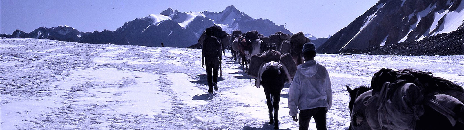
Crossing Pass with mules
Share on Social
ACROSS PANGPO LA
BY RADHA UPADHYAY
(Grateful to the author for contributing about this article about our trek)
On 16 July 1995 Harish Kapadia made the first ascent of Lungser Kangri (6666 m), the highest peak in Rupshu. Ladakh and took photos and bearings including one of a peak named Monto on the map. In 2005, ten years later, we were excited to join him on a trip to try cross the Pangpo la and have a closer look at Monto
We started with a train journey from Delhi to Kalka and thereafter in jeeps to Manali. From Manali, it was a frantic drive through the Rohtang pass, through the high altitude traffic jam! Suman managed to charm the guards who let us through despite the long traffic queues – to the calm of Jispa. Here, we spent a relaxing day acclimatising at a lovely hotel by the Bhaga river, While, bouldering on some nearby rocks, in the early afternoon, I was rewarded with a sighting of a red fox that just made my day.
We continued on from Jispa to Darcha along what has to be one of the most beautiful drives with stunning views of the Mulkila cirque, over the Baralacha la, and past Suraj Tal. Each time I visit the Himalaya, the vast scale of the mountains always astounds me, and this road journey was a fitting demonstration of this scale. From Darcha, the scenery changed dramatically as we entered the flats of Ladakh, and past Phalang Danda which marks the traditional boundary between the Himachal and Ladakh.
Our first camp was at Ting Ting Khur (4280m) about 5 kms ahead of Sarchu and we camped by the Malung River. Unfortunately at that point Suman decided to go back to Delhi as he was not feeling well and our small group became even smaller.
The next couple of days we followed the Malung river first camping at Lama Guru (4320 m) and then at the confluence with Umnak nala (4400 in). It was a beautiful walk through a U – shaped valley. We alternated between walking high up on the side of the valley – whilst the Malung sparkled below, and at other times, descending into the valley floor and walking along the boulders by the river. The terrain was very bare with a few gorse bushes springing up where the ground was a bit wet. The pebbles by the river had pretty black with white markings. some of which looked like Chinese characters,distinct concentric circles and star’s.
We continued following the Malung along the valley floor to Thochhung Ri (4463 ln) and then to the base of the Pangpo gorge. We followed the meandering river along a wide valley floor, and as a result, had innumerable river crossings. Often. when the river swung to the edge of the valley we were forced to wall along tricky sections just above the edge. On the sides of the river valleys rose some dramatic rock spires. That night, before we entered the Pangpo gorge, a Kumauni porter came to our dining tent and said ‘moon is looking great’. And true to his word, we rushed out to see a beautiful moon rise with the pale light mystically reflected off the mountains at the head of the valley.
The next two days were exciting. We began by climbing the scree slopes by the side of our camp up onto a high plateau for about an hour and then descending into the Pangpo gorge. The map said ‘path follows river bed’ but there was really no path. The gorge was steep on both sides and we had to keep jumping across the river at several points. Again the Kumaunis were amazing — putting boulders across the river so we would find it easier to move across. Most of the times my heart was in my mouth — a small slip could have resulted in a serious accident. All along the side of the gorge there were beautiful icicles that were just beginning to thaw with the midday heat.
As we reached the end of the gorge, it was felt that the mules may not make it up this trail. We were making alternative plans and sending some porters down, when Shyamlal the mule driver came into view. And Harish remarked ‘the Kings of Karakoram have done it again!” That afternoon the porters went exploring further up the gorge to scout a route for the ascent to the pass. We later regretted not going with them as they reported seeing a snow leopard. The following day we kept our eyes peeled but we had to be satisfied with spotting only the footprints.
The Pangpo gorge became quite narrow and steep so we decided to follow a high level route on the side of the valley which had to be opened for the mules. We kept following a zig zag route up the side of the valley, dropping back into the river valley and then walking up. Occasionally the barren rock was broken by pretty white and pink wax flowers (bergenia stracheyi). Eight hours later, on 23 June 2006, we stood on the Pangpo la (5305 m) and had our first views of Monto (6230 m).
By looking at the maps and getting the bearings again we realised that Monto was actually not the mountain that Harish had taken a picture of. Monto was on the same bearing from Lungser Kangri as the ‘peak in the picture’ but slightly further southwest. But unlike the peak in the picture it was not a simple snow ridge up to the top but a very dramatic and difficult looking peak.
That night we camped below the eastern base of the Pangpo la near Aiya Paiya chu (river). The following day was another long one but very rewarding. We followed the river which turned north and then east till we reached a beautiful little lake Skam Tso” which had pretty red and pink flowers (sedtan ewersii ) growing at its shores and we saw some Brahmini duck taking flight. Walking by this lake, with mountains all around us, I felt a complete sense of awe of the world and its scale. On the one hand I was feeling elated in being in such a remote place but also it was the sort of place where the insignificance and temporary, nature of our life really hits home.
From there we crossed the nala up a long ridge slope to a hip=h basin. Where again we were rewarded with amazing views of Monto and an adjoining peak 6331. Following the ridge along the basin we then dropped to our ‘base camp’ just above the Arya Paiya chu (river). Unfortunately Rajal was the only serious climber in our group and also we were 5 days behind schedule. It was such a difficult decision but he decided not to attempt Monto. Instead he took about 200 photos of it from every possible angle!
The next day we followed the Aiya Paiya chu and had good views of the mountain marked Kharpa (6170 m). Each of the valleys branching from it hinted at immense possibilities of climbing as we saw some beautiful rock towers. We were to camp at the spot where the Aiya Paiya chu me the Phirse Phu but to our surprise and disappointment, it was extremely dry. We hall to follow it for another 4 km till we found some water rising in a small basin in the river-bed near Manechan. The water from the Phirse Phu and other nearby rivers had probably gone underground. Here there was shortage of water while radio announced serious flooding in the Pare chu, which had damaged several roads in Spiti and Kinnaur. However, this also meant that the second half of our trip – where we were to follow the Pare chu and cross Takling la into Spiti – had to be cancelled.
The next few days were fairly uneventful as we walked from Manechan (4750 m) to Lateke (4670 m) to Khumloche (4600 m) and then Kianqdom (4560 m). However it did get greener and we saw some lovely primulas, asters and edelweiss. I must disagree with Hugh Ruttledge who in 1925 wrote, ‘towards the end of the evening we arrived at the end of the lake, at a poor sort of place, Kiangdom. It was an ugly, morose spot with the howling wind.’ Kiangdom is a beautiful spot at the southern tip of the Tso Moriri lake. We had wonderful views of Lungser and Chhamser Kangri across the stunning lake and also of Gya (6794 m) to our south. There we lots of marmots who kept popping their heads out of their holes. The wind did howl and our toilet tent barely survived – but it was a wonderful place to stay.
There was also a group of Changpas staying by the lake and it was interesting to witness their lifestyle. Besides the ubiquitous solar panel they still continued with the same way of life they had almost a century years ago. They were nomads on the move, herding their sheep and goats and living in semi permanent dwellings made of leather. We talked to them and before long we were invited inside their tent (house) for tea. The following day was even more exciting, a large group of Changpas were on the move. They had come from Hanle and were following the trail on the bank Tso Moriri to Karzok. We were also walking to Kaizok and almost became part of the procession, with yaks, donkeys and cute children all wearing a pendant of the Dalai Lama. Some of the women were wearing beautiful headdresses or ‘perak’ made from turquoise.
At Karzok, on 1 July 2005, our trek officially ended. Some flew home from Leh and some spent time in Ladakh. But each of us left with memories of Pangpo la and the beautiful region we had traversed.
Members:
Harish and Geeta Kapadia, Rajal and Radha Upadhyaya, Sukeshi Seth, Gerry and Louise Wilson and Suman Dubey.
Summary:
A trek across Pangpo la(5305 m) from Lahaul, Zanskar to Ladakh in June 2005.
3. Also known as Kyum Tso
4. The origins of the name Monto remain a mystery. The mountain is named “Monto” even in the earliest maps, but it is not a Ladakhi word and no meaning of this work could be found.