Kone Khang peak, North Sikkim
Share on Social
CHASING CIRCULAR RAINBOWS
The Brocken Spectre
2000
“Have you trekked to Sandakphu ? Yangdu asked me. “It is one of the best treks in the world, uncle”. She had been calling me ‘uncle’, a title you receive as you age in India. Yangdu has a long experience of trekking, particularly around Darjeeling, having been born there. She has lived there for half her life.
“Sandakphu is a window to one of the finest views of the snowy mountains, from the mighty Everest in Nepal, to the revered Kangchenjunga in Sikkim and the legendary Chomolhari in Bhutan. From here Everest is 144 km as the crow flies.” she added with an infectious enthusiasm.
“This trek takes you along the famous Singalila Ridge. Singalila is a prominent spur of high ground that lies at the southern end of a long crest, which runs down from Kangchenjunga itself. It forms the border between Sikkim and Nepal. The trek along this ridge going through small settlements is renowned for being one of the most scenically rewarding in the entire Himalaya. Apart from these giants there are views of a host of other peaks in the eastern Himalaya, all seen at one stretch. – Quite a sight to see even from about 3500 m , the maximum altitude you get to on this trek.” And as a final advice she added, “ Go in autumn, you will obtain the clearest views”. So there I was en route to Darjeeling in November 2000 to taste the best views as promised by Yangdu. She was not wrong.
There are two major advantages of trekking around Darjeeling. First is the great flight from Delhi to Bagdogra (make sure that you have a left hand side window seat). We viewed the entire Himalayan range starting from Bandarpunch, Nanda Devi, Everest and the complete range of Nepal’s high mountains. When you see the Kangchenjunga massif you know, that now you are nearing Bagdogra. From Bagdogra, going up the Himalayan Hills Railway is a long and laborious process and as a result most people now travel to Darjeeling by road and take the little toy train ride from Darjeeling back to Ghoom. This Hill Railway has been declared as “World Heritage Railway”. This is what we did along with a visit to the memorial at the Batasia loop, to the heroes of the Indian Army’s Gorkha soldiers. We visited Himalayan Mountaineering Institute and spent time with old friends. Like all other visitors, a trip to the Tiger Hill early in the morning to view the sunrise was mandatory. I wouldn’t vouch for the peace and sanctity of the surroundings as a large crowd had gathered there and we were told that such crowds are there every day. As the sun rose over the horizon, on one hand the peak of Everest was lighted up in a exquisite change of colours. But on the other , next to us, people burst out beating drums, shouting, and dancing and there was such a big commotion that one felt as if the sun had done something wrong. People have different ideas of enjoyment and shattering the silence in such surroundings was a part of theirs.
I was to trek to Sandakphu in the company of some wonderful friends. Ajit and Usha Mehta are Gujaratis from western India, as I am, and have migrated to Chicago, USA, many decades ago. They, like several other friends of mine, adopted U.S.A. as their country and we in India officially call them as NRIs (Non Resident Indians). Perhaps, in a foreign country they live more like Indians, than we do in India, for we in India adapt to the fast changing society and many times miss out on the traditional beliefs. None of our NRI friends have given up their love for India and have kept the Indian traditions alive wherever they have settled. They visit India and those who have any inclination and interest in the Himalaya always return to trek there. As their children grow up having heard stories about India and the Himalayan range, they too want to be introduced. This was one such group and we all got along very well. With them came their American friends. Dr. Mart and Gina Jalakas who work in the same hospital as the Mehtas. Mart, with interest in many facets of India knew a lot about it and about many other subjects in general. No combination could be better; people from different cultures but with the same background or interests on a trek together, with the same love for the mountains.
It was on first of November, that we were ready to start for our trek and. drove around 30 km to a village called Manebhanjang. . As I started walking , a young lady from our group, Sejal, started walking with me. She was a student from USA who appeared quite strong and fit. I casually asked her, “So Sejal, have you been trekking before ?”. In an American accent she replied, “No, but I have been doing plenty of walking around, plenty of training, long distance jogging and have been for short walks around places in U.S.A”. Then with a pause, she looked at me and said, “How about you, have you been to the Himalaya before?”. I just smiled. I wished I was coming for the first time. For that infectious enthusiasm of the “first time”, that first view of the snow, and that first smell of pines is something which I miss now after so many years in the Himalaya. As Martin Conway had put it :
Later we may know more, we understand more, we may even come to love more; but the first vision of a young man’s love is surpassed by no further splendour, and the glory of a mountain view never comes again.
The trail started with a rather steep climb as one has reach the Singalila ridge. Luckily the first part was a climb for a short distance, about 3 km, and at around noon we stopped at Chitrey, a small hamlet where we had lunch. . As lunch was being prepared in a small dhaba, some of the local boys about 200 ft. above us were playing loud music and making so much noise that it reminded us of the Tiger Hill incident. As we had to sit here for a while, Nilesh Kothari, from our group climbed up to them and waived. The boys would not pay any attention. So he waived out a Rs. 50 note and shouted, “How about stopping this noise”. He was an American and this was his capitalist method of conquering the natives. The boys did not listen and in fact turned the speaker towards us, made it louder and started dancing. Finally it was the tall figure of Dr. Mark Jalakas who climbed up steadily towards them and gave them a piece of his mind. That did the trick. The authoritarian approach had certainly succeeded over the capitalist approach.
We were to climb more than 1100 m to reach the top of the Singalila ridge at Tonglu. By 4 o’clock, with such steepness to overcome, we were dehydrated and tired. As the sun went down in the evening, everything was looking lovely in the autumn light. As we turned a corner on this long winding road, Mark Jalakas who was slightly ahead of me and feeling little tired suddenly stopped.
“Harish look at the Brocken Spectre”.
Mark always knows more about things and as I looked around I saw a lovely circular rainbow riding on the clouds in the valley below. What was incredible was that our shadows were falling right into the centre of that rainbow. It gave us a feeling as if we were riding on a cloud, at least our shadows were. (Such a phenomena was first noticed in the German mountain range of the same name, Brocken).[1] It was an amazing sight and Sejal who was with me went crazy with photographs. The clouds were rushing towards us and we felt as if were riding towards heaven in the centre of a rainbow. All Sejal could repeatedly say was just, “It is awesome, its awesome”.
I had seen such a phenomena in the local hills near Mumbai, in the Sahyadris (Western Ghats). A historical fort of Shivaji, the great Maratha worrier, named Harishchandra Gad, has steep high walls facing the West. In late May, as the build up to monsoon clouds swirl up from the valley to the fort and the morning sun rises from the east. It casts long shadows on these clouds making you feel as if you are walking on them. During the days of the Raj, a British officer once stood at the edge on a horse. His shadow ‘riding’ on the clouds was seen by the simple villagers. A folk-tale developed about British officers who could even ride on clouds, and hence no one dared challenge them !
All the tiredness was behind us and we reached Tonglu with the memory of the this brilliant spectre. Tonglu has a small trekker’s hut and if you are lucky just standing on the balcony you could be treated to a spectacular sunset of the Kangchenjunga range. We were lucky, and looking at this brilliant spectacle again revived many memories. On the second day we had to proceed to Tumling which is at around 2860 m. We were walking on a very broad and rough jeepable trail on the famous Singalila ridge about which I had heard a lot and on which for centuries people have travelled . On the left of the ridge , towards the West, is the Nepali territory and to the East or right is India. Thank God both are friendly countries and no armies are here facing each other. In fact the trails zig zag into Nepal and back to India regularly. We entered the Singalila National Park paying a minor fee and descended 6 km to Garibas . From Garibas, the motorable road continued along the ridge, but there is a lovely foot track which crosses towards the west into Nepal to reach a small village of Jaunbari. We were not an unusual sight for people in the village , they had seen many trekkers. There were small eating joints and everybody was nonchalantly talking to us and busy in their work.
The trail climbed up back to the Singalila ridge rather steeply and we again followed the ridge till we reached Kala Pokhri, literally meaning ‘Black Lake’. In fact, as we reached late evening, the lake certainly looked very black.
On the 3rd day we were to proceed via Bikhey Bhanjang to Sandakphu. It was almost 5 km of steep ascent till we reached Sandakphu. The place almost defies description. Right on top of the ridge we were on an international boundary with a police post and several excellently situated bungalows.
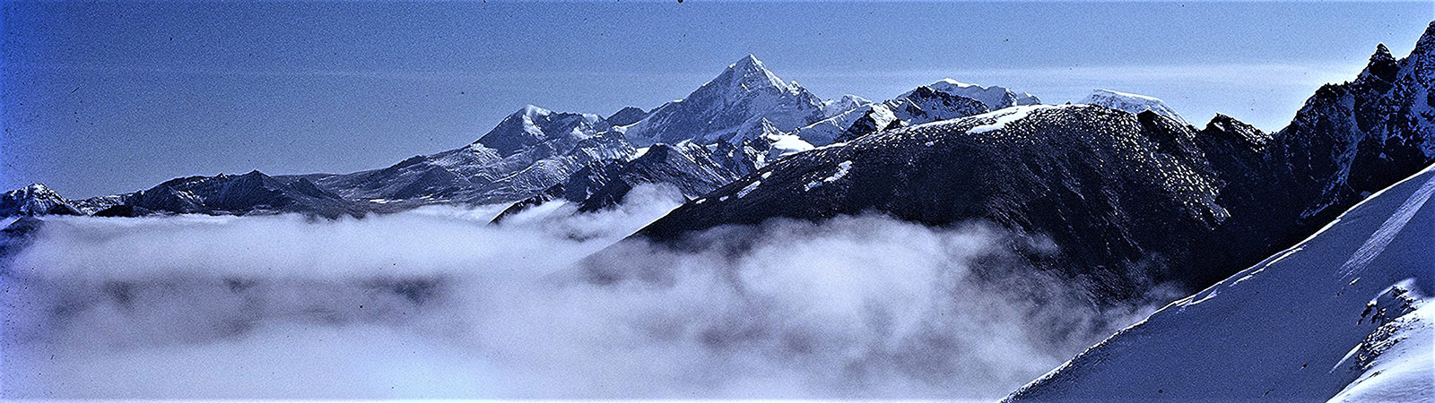
That evening it was very cold, but who cared, right in front of us was the majestic Kangchenjunga and all its surrounding peaks with lovely deodar and pine forests. Peace was all around, and the backdrop was magnificent. Towards the west appeared Everest as a very small dot, almost peeping from behind Makalu. But then there were many who were more excited over looking at Everest than Kangchenjunga. I think being tallest in the world has its advantages and attractions.. Next day we woke up early morning to see the golden sunrise. It was as has been mentioned by an early explorer.
From Sandakphu, the wild elemental grandeur of the snows begins to assert itself, till the climax is reached at sunrise, when it soaks the snow-laden peaks in crimson and mauve, orange and gold, Kangchenjunga and Everest are seen in all their glory against the background of an azure sky speckled with lazily floating, fleecy clouds. The whole snowy range of Bhutan, Sikkim and Nepal, about 320 Km in length, a wonderful square mass of mountains looking like a wall of snow, is visible, but the gigantic height and breadth of towering Kangchenjunga, with its attendant peaks, Kabru, Jannu and Pandim dominates the scene; Everest, (8848 m) now looking rather graceful and majestic, 160 km away, soars above, peeping shyly from the northern horizon with Lhotse on the left.
After breakfast we started on the trail on the ridge towards Molley. As we walked along we could view the beautiful valleys of both India and Nepal. From Sandakphu the same broad trail continued and now all the steep climbs were behind us. As we passed through beautiful open areas with Kangchenjunga on our right and Everest on our left, we crossed a few Nepali villagers who were carrying fresh peas from Nepal and descending into Sikkim for selling them to villagers there. You can easily buy some from them as we did. Eating fresh peas and walking with such a grand view is certainly a different experience. For about 4 km the trail was flat, and finally there was a long steady climb to Sabagram (totally about 5 km further away). To break the long walk to Phalut, a slight detour has been made and after a small descent you reach a trekker’s hut at Molley, about 2 km off the road. Molley [2] was once a camping ground for shepherds. From here a long ridge led down into the Ramam valley making this a convenient camping spot for shepherds travelling from Nepal to Sikkim. Molley was 3600 m and the vegetation was alpine, with an undulating ripple of dwarf rhododendron bushes and shrubs of poisonous aconite
From Molley next day the trail at first climbed back to join the main trail and after some descent there was a 3 km steep ascent to Phalut which is an important view point on the trail. A bungalow has been built little below the highest point.
Phalut forms the junction of Nepal, Sikkim and West Bengal and is one of the beautiful places to visit. The hills are all bare and from here Kangchenjunga is only 48 km as the crow flies. Unfortunately, being cloudy that day we did not get much of a view. Our discussions cantered around from serious, sublime to simple laughter. There were many stories from America and many concerns about India. Our NRI friends, were certainly in contact with everything Indian and in love with the country of their origin. We had heated discussions regarding different aspects of politics, which livened up the evening. We were trekking with mules which were carrying our loads. That afternoon we had reached early and sat down for a chat in the bungalow. Mark Jalakas suddenly rose, and very politely murmured, “I will go out and check the horses”. I looked at him and said, “Mark, the horses must not have arrived as yet”. He looked at me in amazement; “Haven’t you heard the term before ? ” And everybody smiled. He had used a polite American expression, to announce that he was going out for a nature’s call.
The route ahead of Phalut to Gorkhey was certainly not for anyone with weak knees for it descends 1200 m in 15 km. But this descent was through a most wonderful forest. The trail was well trodden. The bamboos and furs ultimately replaced deodars and pines in a day’s wonderful walk. The lower hills were covered with moss laden trees, different varieties of rhododendrons, silver firs, pines, spruce, chestnuts, oaks, giant magnolias and hemlocks.
Tired but satisfied, we reached the small village of Gorkhey at 2390 m. Gorkhey is a small village, which is on the border with the northern part of western Sikkim though foreigners are not allowed to cross into Sikkim via this point. We were on the Ramam river. This is a small river but an important one as it is the boundary of West Bengal and Sikkim to the north. We continued descending and next day and our destination was Siri Khola.
For those who love plants and people this route is a paradise. With a forest of different varieties of the indigenous trees. Samanden, a beautiful village was worth taking a halt at and meeting the simple folks there.. The villagers are basically from the Sherpa clan who many years ago migrated here from Nepal. A legend attracts many curious visitors and Lepcha pilgrims to this quiet village of Samanden. It is said that many years back the legendary Himalayan “Yeti” fought with a Lepcha hunter for supremacy of the hunting grounds here. Due to equal strength on both sides they came to an agreed solution and made a treaty. So, in the quiet woods a huge stone was erected as a symbol of friendship between the Lepcha hunter and the Yeti. These simple villagers’ main source of income is potato farming, fields of which we saw around the lower villages of Rimbick and Ramam.
As we trekked ahead the main difference was that we were beyond the forests, but the pleasures were different. There were small villages that we were constantly passing through. Early in the morning little after we started on the trail Usha and Gina sat down to play a match on carom with the local villagers. While walking from that point we logged-on with a forest party and the forest officer was a mine of information about various legends, stories and happenings in the area. When walking between villages this makes it interesting. You pick up so much from these locals or officials posted there that it makes your trek really worthwhile. [3]
The trekker’s hut at Siri khola was built overlooking the river. It was well placed and with small hotels clustered around, it gave us welcome relief. We cooled off that day and in the evening everyone had a most relaxing time. The last day’s walk was to Rimbick village. It was a flat walk again on a broad trail. That day we almost had a competition as to who would reach the camp last.
Everyone walked leisurely, chatting with villagers, sitting at small way side shops, drinking tea by the roadside dhabas and of course, some food and a glass of beer also went well with trekking. The trail was well decorated with flowers, for the local festival of Dusherra which had recently been celebrated. Yellow flowers were hanging from all windows. The villagers keep these yellow flowers hanging on the windows till they dry up and then the seeds are used for planting . These villagers certainly have an age old eco-friendly tradition. At the end of the road was a small village of Rimbick.
Rimbick (2286 m) is a small important town and is quiet but busy during the main market day i.e. Tuesday, It is a lovely day to watch simple people from different villages coming to buy and sell their local products. Rimbick, which is a Lepcha word means “Ling-gip” i.e. “place where there is a swing.”
Suddenly we were amongst modern facilities. A hot shower, a good clean room and change of clothes made us feel happiness that only civilisation can give. We talked of having completed a lovely trek, hardships faced and loosened our tired limbs.
We saw a different perspective soon. There was a commotion in the bazaar and as we looked around, suddenly there were runners arriving. A Himalayan run was being conducted in the area and all that we had done in about 8 days of trekking , these enthusiast were running, clocking only that many number of hours. But then to each his own, as they say. We saw some runners arriving very tired. They collapsed on the ground and were heard murmuring, “Never again, never again”. I am sure they were running again the next day and returned next year. It is the spirit that counts and looking at these runners you feel amazed at what a human body can do.
All that remained for us now was a 130 km long 7 hour drive to Kalimpong which was our last destination. Kalimpong is a small cosy place which had retained the old British charms. There are many educational institutions, particularly Dr. Graham’s Home which is legendary. Kalimpong was once an important trade centre between India, Bhutan and Tibet. This lovely laid back town with a pleasant climate is famous of its orchid nurseries and handicrafts. This town was surely the best place to wind up the trip and relax before going home.
Everybody was now in great form and a sense of satisfaction enveloped us. The dinner table was a lively affair and memories of the trek were pushing us on. Like all good things it had to end and the next morning we parted company. My friends took a bus and a flight on their way back to Delhi and I took a taxi back to Darjeeling to meet my Sherpa friends. Each one of us were going back to our Brocken spectre in a different way.
Explanations of meaning of some names on the Sandakphu trail.
| Bikhe Bhanjang |
Bikhe- a special medicinal plant which is available in this valley.
|
|
Garibas
|
Gairi- lower place, bas- place to stay. A place to stay at lower place. |
|
Jounbari
|
Joun – Nepali for —–. Bari – village. A village where —- grows. |
| Mane Bhanjang | Mane- old mane stone, stupa which is erected here. Bhanjang-valley. A valley where Mani is erected. |
| Molley |
Molley means ‘gobar’, excrement of cows which is applied to floors in village houses. Many cowherds used to stay here. So it was named ‘a place where gobar is available’.
|
| Phalut |
It was originally called ‘Phale Lung’. Phale – stone, Lung- steep place. A steep stony place. Another explanation given is that Phalu- means head of a cock. There is a rock here which appears in the same shape.
|
| Samadeen |
This is a small village hidden between two valleys. Simply put, it can be called a ‘Lost village’. But a legend is sometimes quoted for this name. There was a dispute between Lepcha and Topcha communities. During a fight both groups were trapped in this valley and heavy rain followed. One group was above the ridge and the other on the river. As a stalemate occurred wiser counsels prevailed and both communities decided to settle here together. The agreement reached is called ‘samadeen’ in the local language.
|
| Sandakphu |
There are different explanations available. But the most likely is about a legendary story almost a centaury ago. A local guide named Santa Bahadur roamed the ridge here. He was a Nepali and guided visitors or shikaris. He was buried in heavy snow and perished. Pur in Nepali means ‘buried in snow or for someone who died accidentally. Thus the place came to be called ‘Santapur’ – the place where Santa died. Over the years due to Sikkimese pronunciation it became ‘Sandakphu’.
|
Summary: A trek to the Singalila ridge in west Sikkim, in November 2000.
[1] Brocken, also called Blocksberg, highest point 1142 m (3747 feet) of the Harz Mountains, lying 13 km (8 miles) west-southwest of Wernigerode, Germany. A huge, granite-strewn dome, the peak commands magnificent views in all directions, and a mountain railway (12 miles [19 km] long) reaches the summit. When the sun is low, shadows cast from the peak become magnified, and seemingly gigantic silhouettes are cast on the upper surfaces of low-lying clouds or fog below the mountain. This effect is known as the Brocken bow, or Brocken spectre, and is given a mystical significance in the mountain’s folklore. Long after the introduction of Christianity, traditional rites continued to be enacted there annually on Walpurgis Night, or Witches’ Sabbath (April 30). The peak is represented in a famous scene in J.W. von Goethe’s drama Faust.
[2] Explanations of place names are given at the end of the article.
[3] One of the stories we heard was about ‘Hamjaya’. This is a recent legend about a taxi driver who drove to Sandakphu. The road to Sandakphu is steep and rough. Many times thick fog and rain makes driving rather dangerous, hence most taxi drivers are reluctant to drive there.
A pretty lady came to the stand once and asked in Hindi ‘Kaun Jaya’ (‘Who will go to Sandakphu’). Only one taxi driver replied ‘Hamjaya’ (‘I will go’). When he did not return for a few days , it was feared that both had perished on the road. As the mourning was underway the taxi driver appeared smiling with the lady as his wife. They had married and spent their honeymoon at Sandakphu. The taxi driver is still known as ‘Mr Hamjaya’ after the reply he had earlier given.