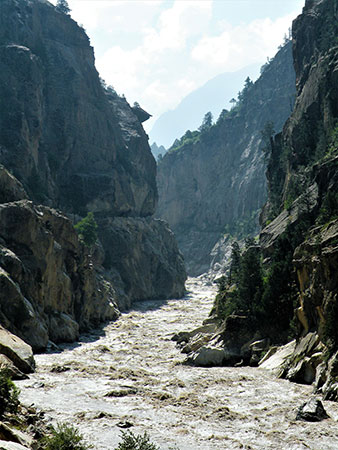
Satluj River on way to Spiti
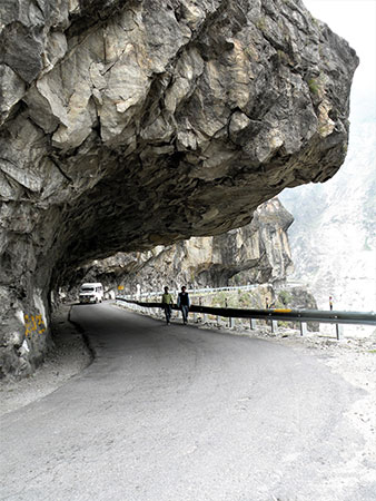
Road to Spiti
Share on Social
UNKNOWN SPITI: THE MIDDLE COUNTRY
1983
MOST OF US have heard of Heinrich Harrer and Peter Aufschnaiter. Their escape and their seven years in Tibet are legend. Like them, M. Paidar and Ludwig Schmaderer had also escaped from the British internment camp during the war. They followed a year after Harrer using much the same route to the frontier and into Tibet. But they returned to Spiti with tragic consequences.
In July 1945 when still wandering aimlessly and not knowing that the war was over, L. Schmaderer was brutally robbed and murdered at or near the little village of Tabo in Spiti. H. Paidar returned to Poo on the Sutlej, and followed the river down to Sarahan where he gave himself up and made a full report to the police. The murderers were arrested.1 It was the first such crime reported in Spiti for over 40 years.2 Perhaps this was for the first time that Spiti was reported in such a bad light.
The earliest travellers here were the famous Gerard brothers. They explored ‘Bashair, Spiti and Kanwar’ (Kinnaur) in 1817.3 Since then except for a mountaineering party it was cocooned in its own fold.
Spiti which literally means ‘middle country’ lies between India and Tibet, and across the main chain of the Himalaya. One of the routes from Kinnaur allows an easy route into Spiti. It is now motorable and kept open for most of the year. The original 6 week journey on foot has been reduced to 24 hours, but is equally tiring with crowded buses, road-blocks and unmetalled roads. About 10 km ahead of Puh, the Satluj river enters India cutting through the Himalaya near Shipki la. The Spiti river flows into the Satluj after its turbulent journey, at Khab. The road climbs up a series of loops (Kah loops) in 10 km to enter the barren lands of Hangrang valley. About 30 km ahead of Chango one enters Spiti at Sumbo. A road branches east to Kaurik, at the bottom of which the Pare Chu river re-enters India. The Spiti river cuts the valley almost in the centre with side valleys joining it broadly from the east and west.
The Eastern Valleys
The road goes along the Spiti river, the valley floor itself now above 3700 m all along. Valleys open up on the east. The first eastern valley is of Giu nala. This small valley leads to the Lingti valley in the north and also has an exit to Tibet. Ahead at the Lingti village, the river with the same name meets Spiti river. Lingti is one of the largest and the longest valleys of Spiti. It is 60 km long and at its northeastern head, on the Tibetan border stands Gya (6794 m) the highest peak in Spiti.
Further ahead one reaches Kaja (412 km from Shimla) the administrative headquarters of Spiti. It is a small place with a few locals but many government employees. It has electricity supplied through a hydro-electric plant from the Ratang valley. Complete with video- parlour, eating houses and rest house it is a far cry from the earlier days, and other parts of Spiti.
Ahead of Kaja the main road crosses the Spiti river onto its western bank. But to the east are the valleys of Shilla nala (though they do not lead to this legendary peak) and Parilungbi nala. This latter nala leads to the famous Parang la (5578 m) which leads to Chumar in the Rupshu district of Ladakh. Some early crossings of this pass by Europeans have been recorded.4 An alternate pass, Takling la (5500 m) is earlier and completes the picture of eastern Spiti.
All these valleys are small in size except the Lingti which goes deep into the mountains taking a northwesterly turn at its junction with the Chaksachan Lungpa nala. At its head lies the pass of Yangzi Diwan (5890 m) and across lies the peak, Parilungbi (6166 m). Descending from the pass on the other side one joins the Parang la route, the relay completing the circle. At the head of Chaksachan Lungpa valley stands the majestic Gya. It is a stupendous rock monolith and offers one of the finest challenges. This peak is circumvented by Pare Chu river. Pare Chu starts at the foot of Parang la and flows to the northeast. After about 30 km it takes a huge turn to the south to enter Tibet for an 85 km journey. It again takes a sharp westerly turn tore-enter India at Kaurik and meets Spiti river at Sumdo. This peculiar course at a very high elevation with such fast flowing water is unique.
The Western Valleys
The eastern valleys had relations with Ladakh and Tibet, the western valleys are joined to Kinnaur and Kulu. After entering Spiti from Sumdo, the large Pin river flows from the southwest exactly opposite the Lingti river. This long valley gives major accesses to Spiti. Tari Khango (4865 m) leads to Pin valley from the Bhabha valley of Kinnaur. The Manirang la (5520 m) allows access from the Ropa valley of Kinnaur to Pin. Little further to the west, the Pin-Parvati pass (5319 m) leads to the Parvati valley and Kulu.
North of the Pin valley lie three still relatively unknown valleys: Parahio, Ratang and Gyundi. Each is a narrow gorge, difficult of approach. Each has a host of peaks, side valleys and no easy passes on the Kulu side. Parahio bifurcates from the Pin valley. Gyundi has three major branches, each a valley by itself. It is proposed to declare the Parahio valley a National Park. This will forbid all entry into the valley by locals, in order to preserve the flora and fauna. The difficult Ratang gorge now boasts of a hydroelectric station right near the glacier. A 10 km road has been blasted out in this gorge. Finally, at the northern end the road climbs up to Kunzum la (4550 m) the traditional western exit into Lahul (and Kulu over the Rohthang pass). This road leads to Manali (201 km from Kaja) and is covered by buses (in 10 hours) and trucks, daily for 6 months in the year.
Climbs and Explorations
Mountaineers have visited Spiti sporadically. The first climber in the area was J.O.M. Roberts in 1939. He made the first ascent of Chau Chau Kang Nilda (CCKN) (6303 m) (then known as Guan Nelda).5 J. de V. Graaff and K. Snelson recceed the area in 1952. But some of the most admirable exploration was done by P.F. Holmes in 1955 and 1956. In the first trip, with T.H. Braham he entered the Ratang valley and made fine ascents. They briefly entered Gyundi valley and made some detailed observations. CCKN was also climbed and the mystery about the height of Shilla clearly established.6 On his return visit in 1956, Holmes was most energetic in climbing and exploring the Ratang and Parahio systems. He ultimately crossed two interesting passes, first from Ratang to Parahio and then into the Dibibokri nala to Kulu. It is to his credit that such a difficult and unknown area was well recorded. To date, no other party has ventured into these gorges, which remain a most inviting area.
Similarly the Lingti valley had no visitors till 1983. An Indian team led by me entered the valley till the Tangmor gorge stopped the party. We returned to Kaja and explored the approaches from Shilla jot, further to the north. In the bargain, 5 peaks were climbed, but the full exploration of upper Lingti eluded us.7 We returned in 1987 fortified by the earlier experience. Lingti valley was penetrated to its head, the problem of locating Gya was solved and the peak photographed. Crossing over Yangzi Diwan pass (5890 m) we crossed the watershed to Ladakh and climbed Parilungbi (6166 m). Shilla for the first time was attempted from the north and also from its eastern col. We returned via Shilla jot completing the full exploration and climbing various other peaks in the different side valleys.
Other climbers to Spiti have mostly repeated the ascents of CCKN, Shilla and Kanamo, all near the Langja village. Their activities are tabulated with references, at the end of the article.
No account about Spiti would be complete without the mention of its many other facets. It has a unique store-house of shales and a unique geological collection. Its Gompas (monasteries) are sights to behold by virtue of their positions, and here religion is a real guiding force. In the last few years it has witnessed much better administration, progress by way of road-building, bus services and canals. The average Spitian is better off even in the worst of winters. Of course some loss in cultural values is evident, but then, progress has its price.
In spite of the greater access and communication, luckily for mountaineers there has not been an excess of climbing activity. To a mountain lover it is still an unknown and inviting proposition with several trekking routes and hundreds of unclimbed peaks. To an outsider, let alone the mountains, even the area and name Spiti inspires awe. It is as forbidden as ever. After Schmaderer’s murder, Paidar had gone back to the internment camp. Thank God he did not stay seven years and write about it!
Select Bibliography of Books on Spiti
- Himalayan Wonderland by M.S. Gill. (Describes rituals and traditions of Spiti).
- Himalayan Circuit by G.D. Khosla. (Covers cultural traditions).
- Mountain and A Monastery by P.F. Holmes. (Describes two visits and climbs. Most exhaustive record).
- Himalayan Odyssey by T.H. Braham (see chapter on Spiti).
- Men and Mules on Mission of Democracy by P. Sharma. (Describes work of an election party to Spiti).
- District Gazetteer of Lahul and Spiti. Government of Himachal Pradesh. (Covers mostly administrative details).
- Temples and Legends of Himachal Pradesh by P.C. Roy Chaudhury (see chapter on Spiti).
- Indo-Tibet Border Police Bulletin, October-December 1975 (see article by K.C. Mehra, a most exhaustive work on Spiti).
- Lahaul-Spiti: A Forbidden Land in the Himalayas by S.C. Bajpai.