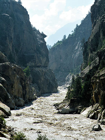
Satluj River on way to Spiti
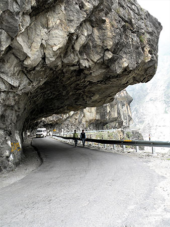
Road to Spiti
Share on Social
SPITI – THE LAND OF MOUNTAINS AND MONASTERIES
Far in the north Himalaya lifting high
His towering summits till they cleave the sky,
Spans the wide land from east to western sea,
Lord of the hills instinct with deity.
Kalidasa, Meghdoot
Spiti’s barrenness is stark, as compared to the relative greenery of Lahaul, with which it is administratively linked. In this respect Spiti is closer to the trans-Himalayan expanse of Ladakh to its north. With Tibet to its east, Kinnaur to the south, and Kullu to the west, this region of Himachal Pradesh is the ‘middle land’, surrounded by mountain ranges on all sides, remaining largely unexplored till 1955-56. The river Spiti originates in its northernmost valleys, at the foot of Kunzum La, and it is joined by Takling Nala and Gyundi Nala flowing in a south-easterly direction, and it divides the entire district. Towards the east lie major mountain areas and the deep valleys such as the Lingti valley that leads towards Tibet. Two well-known peaks stand on this side, Shilla (6,132 m) and Gya (6,794 m), the highest in Spiti. On the west are the remote valleys of Gyundi, Ratang and Khamengar, some of the last to be explored in the Indian Himalaya, given the difficult terrain and the formidable gorges, and the peaks of Ratang Tower and Shigri Parvat.
History
Surrounded by the powerful kingdoms of Rampur-Bushahr in Kinnaur, Kullu, Ladakh and Tibet, Spiti’s fortunes waxed and waned in accordance with its neighbours’ political game plans. In AD 1262, the Mongolian invader, Kubla Khan, conquered Tibet, which then contained Spiti. After the fall of his Tartar empire in the early 17th century, Spiti remained part of Tibet until Senge Namgyal, the greatest of Ladakhi kings (c. 1570 to 1642), conquered this territory, though he could never really establish effective control over it. Spiti changed hands several times with various rulers, and finally when Namgyal’s force could not win, one of his sons was married to daughter of a Lhasa general and was given Spiti as dowry. In 1700, Raja Mansingh of Kullu invaded Spiti and established the first army presence in the area. After a relatively long spell of peace, Spiti witnessed yet another invasion in 1842, by the armies of the great Dogra general, Zorawar Singh. Local chieftains called Nonos were appointed by Zorawar Singh for administering day-to-day affairs, and they held a lot of power and could award death penalty to criminals.
Meanwhile the British interest in Spiti was growing stronger, as not only did it adjoin the pashmina-rich Tibet, but it also provided access to the pashmina producing areas of Ladakh. The wool trade governed the power struggle that ensued in 1846, and General Alexander Cunningham, a British administrator, surveyed the area and systematically incorporated Spiti into British India. In 1864, taking advantage of the vacuum created by the reigning Nono’s death, the British firmly placed Spiti under their control. After India’s independence, it became a part of the country. Entry to the region was controlled following the Sino-Indian war in 1962, and these restrictions remained in force until 1993, preventing foreign mountaineers from exploring this area.
However, before this period of curbs and checks, Spiti did see some explorers and climbers. In 1945, after the Second World War had ended, L Schmaderer and H M Paidar, German mountaineers who had earlier escaped from the British internment camp in Dehra Dun to Tibet, journeyed back to India via Spiti. When they reached a small settlement which contains the Tabo monastery, Schmaderer decided to stay behind, a luckless move as he was robbed and murdered. Ironically, this infamous incident brought Spiti to the notice of the western civilization, opening up the road to this hitherto unknown land.1
Even though several traders and travellers had passed through its valleys en route to Ladakh, not much attention had been paid to Spiti’s mountains, particularly in the west where three large gorges of Khamengar, Ratang and Gyundi remained inviolate. In 1955 and 1956, Sir Peter Holmes’ small British team entered the Ratang valley and climbed Ratang Tower (6,312 m) to its north and also explored this area thoroughly. An Irish mountaineer, Joss Lynam and Hamish McArthur, a British climber, followed Holmes’ footsteps in 1958, moving a little north of his area, exploring the Gyundi valley and crossing the Gyundi pass (about 6,000 m) in the west into the Barashigri glacier in Lahaul. Since then for 35 years these valleys were left alone till an small Indian team, Kaivan Mistry and Harish Kapadia, crossed from Khamengar to Ratang valley in 1993. They went into many side valleys and had reached the area across Pin-Parvati Passs. However in 2000, Kaivan Mistry was drowned in the Shyok river in the East Karakoram.
Gya, the Highest Peak in Spiti
The region was visited in 1983 and 1987 by a small Indian teams (led by Harish Kapadia) that penetrated deep into the remote Lingti valley, east of the Spiti river. Passing through gorges, negotiating the Lingti and Tangmor rivers in two separate expeditions, these teams climbed about many peaks, explored the entire Lingti valley area and crossed many high passes such as Chaksachan La and Yangzi Diwan. One of their important achievements in 1983 was the discovery and photography, from close quarters, of Gya (6,794 m), a mountain that had defied explorers for a long time.
The legendary Gya is situated on the border of Spiti and Tibet, and stands majestically amidst two other high unnamed peaks. To the north of Gya are its three satellite, and as an expedition approaches the peak from the north, the lower peak of Gyasumpa is seen above the base camp. The main summit of Gya rises behind it and unless one is accurate in map reading and observation, confusion arises. On the ridge parallel to the Gya stands the Gyagar (6,400 m), and any team approaching the Gya from the Lingti valley could get baffled without the correct information. Between 1995 and 1998 Gya had been attempted four times without success.
In 1998, an Indian Army team claimed to have climbed the Gya by its north- west ridge, but their scanty photographs from the summit made it difficult to substantiate their assertion. Finally, in the year 1999 Gya succumbed to the
1 See excerpt from the Himalayan Journal in this book.
Indian Mountaineering Foundation (IMF) team, which made a determined attempt on the summit by the south-east as well as the north-west ridge. On reaching the peak via the north-west ridge, they discovered a piton and a rope that had been left behind by the Indian Army team a year before; they had been the first ones to reach the top !
A monument stands near Chumar, north of Gya, in memory Arun Samant, an architect from Mumbai. He had participated in many Himalayan expeditions, and was especially attracted to Gya having seen it first in 1987 as a member of the Harish Kapadia’s team and later investigated approaches to the mountain twice. He secretly rushed to climb the peak along with two inexperienced climbers in an effort to beat the IMF team in 1999. They did make an ascent but of the gentle Gyasumpa, and they must have realised their mistake as Gya can be seen at some distance. Dejected and heartbroken, Samant was too tired to make it to the camp and he spent two nights in the open, which coupled with fatigue and dehydration was probably the cause of his death.
Peak Shilla and Monasteries
To the south-west of Gya is the Shilla, known as the ‘Parang La No. 2 South’ when it was climbed in 1860 by a khalasi. During the time, the Survey of India had been identifying the high points, measuring peaks and mapping the area in the Himalaya, and the khalasis, usually local persons who assisted surveyors in their task, would mark the peaks by erecting a pole. Shilla’s height was established at 7,029 m (23,064 ft) and the ascent was reported in the Synoptical Volumes of Trignometrical Survey of India in 1910. It was the highest summit to have been climbed at the time. In 1939, J O M Roberts observed the peak from Chau Chau Kang Nilda, a 6,303 m high peak and felt its height to be suspect. Although modern survey later established Shilla’s height at 6,132 m (20,120 ft), this did not diminish the grandeur and remoteness of this lovely peak, nor did it detract from the heroic efforts of the khalasi to reach it. Kenneth Mason succinctly put things in perspective when he made the following observation, “He [the khalasi] did not know its height and we do not know his name.”
In the lower reaches of Spiti is the beautiful monastic complex of Tabo, founded more than a thousand years ago in AD 996. Kinnaur to the south affords an easy route to Tabo, which is built on a vast plain and contains unusual mud structures and caves with paintings. It is one of the five well- known monasteries in Spiti. Travelling northwards to the confluence of the Pin and Spiti rivers, up on the Dankhar ridge, is the new Dankhar Gompa that was built in the 1990s and holds a great significance for Buddhists and tourists alike. The old monastery, constructed in the 12th century, stands in a dilapidated condition nearby. At a height of about 4200 m, Dankhar is well sheltered by mountain ranges on all sides and was once the capital of Spiti. Due to its proximity with Tibet, Buddhism spread in Spiti over many generations as several lamas travelled to Spiti, establishing some beautiful monasteries.
One of the largest and most visited monasteries is Ki, lying 12 km to the north of Kaja, the district headquarters of Spiti situated in its centre. Standing on a hill, the monastery is easy to approach, and several hundred lamas live here. It receives many young entrants as Spiti has a tradition that the first male child will enter the holy life, as long as there is another male sibling in the family. The three monasteries, Tabo, Dankhar and Ki, represent the Gelug-pa sect of Buddhism. The other two monasteries, representing the Sakya-pa and Nyingma-pa sect are Tangyud and Gungri respectively. Tangyud is the monastery of the rulers, the Nonos of Spiti, situated 4 km east of Kaja. The Gungri monastery of Pin valley is one of the oldest in Spiti and is said to be founded in the 9th century by Padmasambhava, the Buddhist apostle. Destroyed in a fire, it was rebuilt in the 1990s about two km from its original site on the road leading to Kaja, breaking Spiti’s long spell of isolation which lasted till about 1970s, when its roads started being constructed. Since 1993 the area is totally open, to foreigners even, and anyone can approach the valley when it is not snow-bound. It is a new sort of visitors in the long history of Spiti.
Amidst the gradual invasion of modernity, Spitians continue to adhere to their traditional way of life to a large extent, braving cold winters and subsisting on trade with the plains below, now far more accessible than Tibet and Ladakh due to the improved network of roads. Spitians used to get salt and wool from Ladakh and Tibet, carrying these goods to Rampur-Bushahr and Kullu, both important kingdoms in the early days. The peaks of Gya and Shilla stand testimony to the land’s turbulent history, and to the remarkable resilience of the people who have withstood several invasions.