Exploring Teram Shehr Plateau
Share on Social
SAGA OF SIACHEN
1998
Mountaineering and War On The Siachen Glacier
Whatever the hardships,
Whatever the difficulties, let me
O’Allah, return thither again.
(A Balti saying)
For every mountaineer some areas are more attractive than others. For me the lure of the East Karakoram worked like a magnet. I had not visited any trans-himalayan areas till 1980. But once I found a trail there, the grey and barren valleys of the East Karakoram became my main areas of travel and climbing. What differentiated these areas from the others was their rich history. Caravans had passed through here for centuries; Dogra Generals had conquered it and the ‘Great Game’ was played within its confines. Visiting this region was almost as much an intellectual pleasure as a physical achievement. Amongst all these ranges the Siachen Glacier with its long history, high mountains and the present day war scenario became a major attraction.
The Siachen Hurdle 1996
I had crossed the snout of the Siachen in 1985 for the first time, explored the Terong valley, climbed peaks and played a small part in its history. I nursed a desire to return there to reach the head of this long glacier. After a great deal of correspondence with several government departments, I got permission to trek there, in 1996. We first climbed in a side valley, Terong. When we returned to enter the main glacier we received the incredible, devastating news that our permits were withdrawn by a senior commander in the army. Reason and compromise did not work. He wouldn’t budge. Our protests followed and as we returned to Leh the army relented and I was asked if we would go back. I refused stating that we were civilian mountaineers for whom time and mood mattered. We could not go back to the area like soldiers under orders. A critical report followed and I spoke at different gatherings narrating my bitter experience. I was like a hurt child. I had great respect for the Indian army and felt betrayed.
So when I applied to visit the glacier again in 1998 I was apprehensive about obtaining the clearance. There was discussion within the army about whether or not to allow us, mainly because of my criticism of the army in the past. But now there was a different General in charge. Disregarding the opinion of his staff officers he decided to send us to the glacier. With my faith in the democratic Indian army restored, I returned to the Siachen glacier.
The Legends and History
Two questions are often asked when I mention the Siachen Glacier where a war is raging between the Indian and Pakistani armies since 1984. Though there are no human settlements there nor any productive use of this area, why is this glacier so important to the both the countries? And secondly what are mountaineers doing in a place where artillery shells are regularly exchanged? The answers to both the questions lie in the geography and history of this glacier. It is said that a nation which does not know its geography is condemned by history. So it is imperative that issues related to this glacier are better understood.
It is commonly believed that before the conflict started in 1984, the Siachen Glacier had been lying in quiet isolation. Given the inhospitable climate of this region, such a belief is understandable, but not true. The glacier has had visitors for a long time, both local and foreign.
In the valleys to the west of the glacier live the Baltis, who have an interesting story to tell about the Siachen Glacier, which they called Saichar Ghainri. They say there used to be a small Yarkandi village at the entrance of the Teram Shehr Glacier, where the Yarkandis met the Baltis for trade. (The Workman couple found the walls of such a settlement in 1912). It so happened that once some of the Yarkandis descended the Ghyari nala and abducted a Balti woman. Wanting to take revenge, through the Baltis sought the help of a famous mullah. He gave them a tawiz (amulet) whose power, he said, would punish the Yarkandis. He instructed them to place it on the Bilafond la (pass) and return via a different route, throuth the Nubra valley. The Balti villagers disregarded the mullah’s instructions and returned the way they had gone. Soon a great storm hit the Siachen Glacier and caused immense destruction. It is believed that the storm would have destroyed everything in the glacier had the mullah’s directions been followed completely.
As it was, the destruction was not total and the wild roses that grew aplenty near the snout of the glacier and in the lower valleys were spared. It is these roses which give the Siachen Glacier its name: Siachen — the Place of Roses (in the Balti language, “sia” is “rose” and “chen” is “place of”).
From the time of W. Moorcroft, who passed near the glacier’s snout in 1821, the existence, length and location of the Siachen Glacier was a matter of much speculation among Western explorers during the colonial period. In 1848, Henry Starchy became the first Westerner to discover “Saichar Ghainri” (“ghainri” is “glacier” in Balti); he ascended it for two miles from its snout in the Nubra valley. E.C. Ryall of the Survey of India sketched the lower part of the glacier in 1861, and ascribed to it a length of 16 miles.
During his famous second Karakoram journey in 1889, Sir Francis Younghusband (then Colonel Younghusband) approached the area from the Urdok Valley. He was seeking a crossing into the Subcontinent from Central Asia. Following a side valley of the Urdok Glacier, he reached the foot of the Turkestan la. He felt this pass, and not Bilafond la as it was then believed, was the main axis of the Karakoram. In other words, Younghusband thought that the axis along the Turkestan la (along with the nearby Indira Col) was what separated South Asia from Central Asia.
Defining the actual axis thus meant that several square kilometres of territory would be added to British India at the expense of Chinese Turkestan (now Xinjiang province). Younghusband’s explorer’s instincts were correct, but since this was still uncharted terrain he could not be sure.
Younghusband’s belief was confirmed in 1909 by T.G. Longstaff who, along with Arthur Névé, and Lieutenant Slingsby, was the first to traverse this great glacier. They crossed over the Bilafond la (or, Saltoro pass, as Longstaff called it then) and named the glacier in the east Teram Shehr (‘Destroyed City’) in keeping with the legend of the mullah which was narrated to them by their Balti porters. The peaks there were named the Teram Kangri group. They then retreated by the same route and went down the valley and approached the Siachen Glacier via the Nubra valley. Longstaff climbed up from the Siachen snout in the south and observed the same peaks as he had identified from the Bilafond la. This was conclusive proof of the length of the Siachen Glacier and the actual location of the Turkestan la-an important discovery as it established the true dimensions of the Karakoram. What he wrote in his book This My Voyage is quoted often:
Younghusband was a true prophet. Col Burrand of the Survey had suspected the truth. The avalanche-swept pass, whose foot Younghusband had reached 20 years before, was on the main axis of the Karakoram range which thus lay miles farther north than had been believed. We had stolen some 500 sq miles from the Yarkand river systems of Chinese Turkestan, and joined it to the waters of the Indus and the Kingdom of Kashmir.
The next important explorers to visit the Siachen Glacier were the famous Workman couple. Fanny Bullock-Workman and William Hunter Workman were Americans who had a special interest in the exploration of the Karakoram, and they focused their attention on the Siachen Glacier in the years 1911 and 1912. Entering via the Bilafond la, the Workmans camped on the glacier with a large entourage of porters and two Alpine guides. This group spent more than two months on the glacier and they climbed many peaks and visited almost all the corners of the upper Siachen. Grant Peterkin, a surveyor attached to this expedition, surveyed the glacier thoroughly and named a few peaks, including Teram Kangri, Apsarasas and Ghent. Names like Sia la, Junction Peak, Hawk, Tawiz and a few others were given by this expedition. It was the Workman expedition which visited and named Indira Col (lowest point on a ridge) after the Hindu goddess, Laxmi, one of whose many names is Indira. (The general supposition that this col was christened after Indira Gandhi, who was the prime minister when the Indian troops captured it in 1984, is erroneous.)
In 1929, Dr Ph. C. Visser of the Netherlands, on his fourth trip to the Karakoram, explored the two Terong glaciers and the Shelkar Chorten glacier all unknown till then. In his group were Rudolf Wyss and Khan Sahib Afraz Gul of the Survey of India, who stayed in the Terong Valley and completed surveying and naming of the main peaks in the lower part of this great glacier. In the same year, the Duke of Spoleto expedition (Italian) crossed the Karakoram by the Muztagh pass and reached the Turkestan la from the north. They descended from the Turkestan la after discovering the Staghar and Singhi glaciers.
The survey and exploration of the Siachen was completed a year later by another Italian, Giotto Dainelli. Recounting his journey up to the Teram Shehr glacier junction through the Nubra valley in the Himalayan Journal, Dainelli wrote:
…thus reaching the Siachen tongue with all my baggage, a caravan of seventy coolies and six and a half tons of food for the men, carried by an additional caravan of ponies and supplementary coolies. On the 9th of June-exactly two months after my departure from Florence-I was heading for my first depot up the glacier. I hope my English colleagues will appreciate this rapidity of execution, which I consider a record! (Compare this with present timings-one can reach the glacier’s snout within three days from Delhi without taking a single step.)
Dainelli, with a Miss Kalau as his only companion, stayed at the Teram Shehr junction and carried out various geological surveys. He could not return by the same route due to the flooding of the Nubra valley in the lower reaches. So he crossed over to the Rimo glacier in the east by a 6200 m pass which he named Col Italia.
World War II, and the turmoil of Indian independence put an end to all activities in this area for a few decades. After the Indo-China War of 1962, the entire area became ‘restricted’, even for Indian climbers, although it is known that some parties from Indian security agencies did visit Bilafond la.1
The Politics
The ambiguity about the exact delineation of the border is the cause today’s conflict. The 1949 Indo-Pakistan agreement demarcated the cease-fire line. It extended up to the point known as NJ 9842 near the Shyok River, after which the line moved ‘thence north to the glaciers’, leaving the boundary vague.
The one opportunity to do away with this uncertainty came during the 1972 Shimla talks. It can be safely said that there may not have been any fighting on the Siachen if, during those talks, Indira Gandhi had pressurised the Pakistani Prime Minister Zulfikar Ali Bhutto to agree to demarcate the borders along the Saltoro Ridge, as is the situation today. A desperate Bhutto had pleaded with the Indian prime minister that he be trusted to do this at a later date, as he did not want to antagonise his generals. Aap mujhpe bharosa kijiye (Trust me), he is reported to have said.
Even as the ambiguity about the line of control remained, however, between 1972 and 1983 Pakistan promoted and permitted many foreign expeditions on the Siachen Glacier. These expeditions, accompanied by Pakistani army liaison officers, generally crossed over the Gyong la, Bilafond la or Sia la to enter the glacier, and climbed many peaks on the glacier. These climbs are the grounds on which Pakistan had laid claim to the glacier. It has to be noted here that, apart from the ‘political statement’ these expeditions made, the teams were able to do explorations and climbs of the highest order. Peaks like Teram Kangri, Singhi Kangri and others, have been climbed in the area.
During this period, the Indian army also sent three expeditions to the glacier. Two of these were led by well-known climber Col N. Kumar. They reached Indira Col and climbed several other peaks, including Saltoro Kangri and Teram Kangri. The fact that these expeditions (1978, 1980 and 1981) took place was made public only in 1983. The Indian government made an attempt to pass them off as mountaineering ventures but their actual intentions were pretty obvious.
Maps soon began to be published in Europe showing the extended line of control joining the Karakoram Pass in the east following the Pakistani claim. These maps conceded the entire Siachen Glacier to Pakistan, and showed Pakistan and China sharing a long common border to the east of Siachen.
In 1984, Pakistan gave permission to a Japanese expedition to attempt Rimo, a peak located in a side valley east of the Siachen and overlooking parts of Aksai Chin. Such an expedition would have linked Pakistan-controlled Kashmir with China, along the historic trade route that leads to Chinese Turkestan over the Karakoram Pass. The Indian army decided to take action to prevent the expedition from proceeding, and thus began the Siachen imbroglio.
Soon after India occupied positions on the glacier, the first Indian mountaineering expedition arrived in the Siachen to counter the policy adopted by Pakistan in the past. The following year, in 1985, an Indo-British expedition (led by this writer with Dave Wilkinson) was given permission to climb Rimo peak, by approaching it from the Nubra valley in India. Their success and the international publicity generated created awareness that the area was controlled by India. In 1986, an American team reached the Indira Col.
There was one more chance for peace over the Siachen Glacier when Gen Zia-ul Haq and Rajiv Gandhi agreed to a cease-fire. Tensions on the glacier eased but not so domestic political tensions, particularly in Pakistan. Benazir Bhutto, then in the opposition, marched the streets with bangles on a plate for Pakistani generals. ‘Wear these bangles if you cannot fight on the Siachen,’ she taunted. Unfortunately for peace in Siachen, Gen Zia was killed in a plane crash in 1988, Benazir came to power the next year and hostilities resumed on the glacier. One of her first official acts was to visit the Pakistani side near the Siachen Glacier. Peace has had no chance after that.
Mountaineering on the main glacier ceased until 1996, when my team from Bombay arrived on the glacier with full clearance from the Indian government but was turned back.. However, after protests and a critical report, the situation was rectified within a year and it was decided to allow Indian mountaineers on the glacier. In 1997, an Indian women’s team (led by Bachendri Pal, the first Indian woman to climb Everest) traversed the glacier and stood on India Saddle, a point some seconds north of Indira Col.
It was in this situation that we returned to the glacier to complete our unfinished venture.
Rose Expedition 1998
The 72 km long Siachen glacier, in the East Karakoram is one of the longest glaciers in the Himalaya. It has a number of peaks, side valleys and at its head lies the Indira Col, the divide between South and Central Asia. The Nubra river drains the glacier and ultimately joins the Shyok river near Khalsar. To the west lies the West Karakoram (now under Pakistani control) and towards the east is the Shyok basin, bordering China. The northern slopes of the Indira Ridge lead to the Shaksgam valley.
On 30th June we moved to an army base camp after proper acclimatisation in the lower Nubra valley. The army agreed to shift some rations and kerosene by helicopter to the middle of the glacier and to provide food at intermediate camps. By 3rd July we were ready to move up the glacier with 8 Sherpas as support.
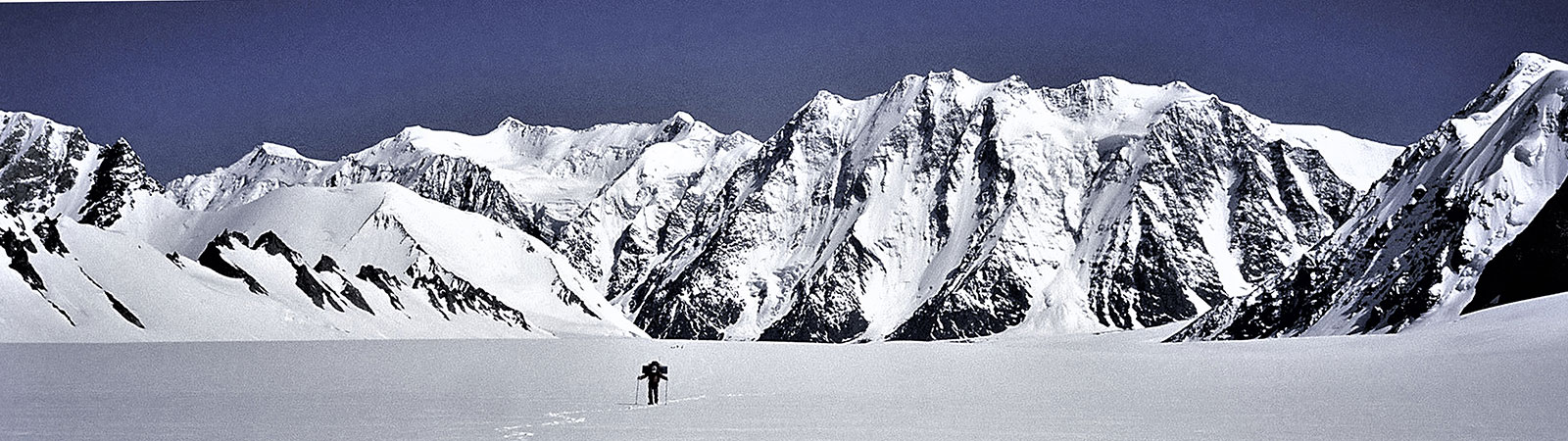
Soon we were treading on the historical grounds. It was a great feeling moving up the glacier once again. We passed the entrance to the familiar Terong valley in the east. We had explored it thoroughly in 1985 and again in 1996. We stayed at the northerly turn of the glacier. Several peaks rose in the south and east while to the west we saw the Gyong la valley which led to the famous pass of the same name. Many expeditions had come up to Siachen by this pass. In the next 7 days we gradually built up our supplies, moving the equipment and specialised food up the glacier over 3 camps. These camps were on moraine as the snow had melted. We were camping on rocky grounds everywhere. After the third day we saw several groups of peaks rising in the northeast. We saw the massive Singhi Kangri (7751 m), justifying its name (Singhi – ‘difficult’). In the same group was Afraj (6815 m) (‘one who leads others’) Khan Sahib Afraj Gul was an Indian Surveyor who visited the area in 1935 with the Visser expedition and had named several peaks in the area. We have named this central peak of the glacier after him). From the middle of the glacier the view is as stupendous. In one sweep we could see the upper Siachen glacier leading to India Saddle and the Indira Col. In the east rose the gentle Teram Shehr glacier with Junction peak rising from the only green meadow on the edge of the glacier. To our immediate east rose the peaks at the edge of the Teram Shehr Plateau. Bullock-Workman had named one of the peaks as “Laxmi” (wife of Vishnu and goddess of wealth). As Lord Vishnu is God of preservation we chose to name some of the peaks after him: like Padmanabh (7030 m), the highest peak on the Teram Shehr (‘destroyed city’) Plateau. It is hoped that Vishnu will protect and prevent further destruction there.
Teram Shehr glacier
Apart from traversing the entire glacier our expedition had two other aims. One was to reach Col Italia at the head of the Teram Shehr glacier and attempt the highest peak on the Teram Shehr Plateau, Padmanabh (7030 m).
A good route to approach the Teram Shehr Glacier was opposite the famous ‘Kumar Camp’. A wide gully flowed down from the Teram Shehr onto the Siachen Glacier. On the right of the gully were the gentle slopes; the only green slopes in the area. These could possibly have been the site of the settlements mentioned by the Workmans. The best way to approach the Teram Shehr glacier was via this gully, which would have saved us the long turn-about approach. But the 2.5 kms across the Siachen Glacier was not considered safe and had to be crossed under cover of darkness to avoid the risk of being caught in the shelling from across the border.
So it was decided that Divyesh and Cyrus with support would attempt the peaks on the Teram Shehr plateau directly across Camp 3 which was below. They were to follow a ridge line of Bhujang (6560 m) which was at the edge of the Teram Shehr plateau, and then make their way to the base of Padmanabh (7030 m). Any thought of reaching Col Italia had to be given up. Throughout our stay we were always aware of being in a war-zone. There was daily artillery firing across and above our route, helicopters were flying and we met soldiers on their way down, tired and haggard. It is a very different playground for mountaineering.
First Ascent of Bhujang (6560 m) on the Teram Shehr plateau
After we left for Indira Col the climbers descended to Camp 3 to attempt the peak. From 10th to 14th July they built up a base camp across the main Siachen glacier, on its eastern bank. On 15 July they climbed over loose scree and mud slopes and reached the steep ridge descending from Bhujang (6560 m). At about 5570 m they camped at a sheltered spot with a grand view of the peaks and glaciers around.
After the weather cleared they moved on the 18th to the last camp now within reach of peak 6560 m. Starting early and moving fast Cyrus and Divyesh went up the initial frontal 500 m of the climb to the point where the ropes and equipment had been left earlier. The Sherpas moved up the rock route along the ridge. From this point they found a safe passage to traverse onto the col. The route from the col to the top was an easy angled climb over snow with a few patches of ice inbetween. They were on the summit by 11.30 a.m.
This was the first peak climbed on the Teram Shehr plateau. It rose like a serpent and was christened ‘Bhujang’, after the legendary serpent associated with Lord Vishnu.
To Indira Col
In the meantime the main team moved up the glacier which was completely snow-bound even through the summer months. Almost 30 to 40 ft of snow covers the entire glacier in winter and the temperature plunges to below minus 40 degrees C. We were visiting the glacier during best time of the year and to the easiest part of the glacier. Yet the cold was harsh and the hardships ahead evident. The glacier flattens out ahead of its centre. We passed a side-entrance leading to Bilafond la (‘butterfly shaped glacier’) in the west. This was the Lolofond glacier (named after Dr Tom Longstaff). It was small and flat and joined the Siachen after a small expanse . The historic peak of Tawiz (6400 m) dominated the sky. To the northwest another historic peak, Hawk (6754 m), raised its head. Thence it guided us throughout till the head of the glacier. The site of the Saltoro Kangri peaks (7742 and 7705 m) rising above the Peak 36 glacier was unforgettable. Its sheer size and the difficulties of the rock walls on its slopes makes it a challenging objective. Today Saltoro Kangri II (7705 m) is one of the highest unclimbed peaks in the world.
After four more camps we were nearing the head of the glacier. There were not many serious obstacles except for a few crevasses. We walked in short marches in excellent weather. A little while later we passed another valley in the west leading to Sia La and Convey Saddle. The Siachen glacier was now broad and on its eastern edge rose two shapely pinnacles (Staghar Towers I and II), There was a deep notch to its south. This was Staghar Pass through which the Japanese expedition had crossed to the east to make the first ascent of Singhi Kangri. Soon we neared our goals, Sia Kangri I (7422 m) and II (7092 m) (formerly known as Hardinge). Their walls were gigantic and threatened to throw down avalanches. All camps were carefully placed away from them. Our last camp on the glacier was a little above the ‘Ridge Camp’ of Bullock-Workman in 1912.
We decided to reach Turkestan La (East) (5810 m). It lay on the head of an eastern valley. On 20th July 1998 four of us with our LO and a Sherpa left by 6.30 a.m. Winding our way through a crevasse and going up a gentle valley, we were at the la in 2 hours, overlooking the Staghar glacier. The eastern slopes led gently down to the glacier and the ice-penitents of the Staghar glacier were clearly seen. The view to the south included several peaks around the Singhi Kangri ridge, with Staghar Pass clearly visible. One admired the tenacity of the Japanese team which in 1976 crossed Bilafond la and Staghar Pass to ultimately climb the steep and sharp ridge of Singhi Kangri.
The Indira Ridge
The ridge on which we were standing rose gently towards the north and a deep notch was seen on it. This was the Turkestan La (North) where Col. Francis Younghusband (later Sir) wanted to reach in 1889. It is sometimes called ‘Colonel’s Col’. The Indira ridge leading from foot of Sia Kangri to ‘Colonel’s Col’ and turning south to Turkestan La (East) is the northernmost ridge of India at present and it forms a major divide between South and Central Asia.
The main Indira Col (west) is located at the foot of the eastern ridge descending from Sia Kangri. It is here, exactly, that the heads of the Siachen and Urdok glaciers meet. This col was recorded to have been reached by Col. N. Kumar’s team in 1981 and again by the Americans in 1986.
On the same ridge a point of 6000 m is erroneously marked on the present map as ‘Indira Col’. It is a steep saddle and by no imagination can be called a ‘col’ (a col is the lowest point on a ridge). We proposed to call this point ‘India Saddle’. Further east lies the Indira Col (East) which was reached by Bullock-Workman expedition in 1912. The easternmost pass on this ridge is Turkestan La (North). It is an easy pass on both the sides and foot of this pass was reached in 1889 by Col. Younghusband. The ridge turns south from here. Turkestan La (East) is located a little to the South.
Reaching the Northern Points
On 22nd July 1998 we started at 6.30 a.m. and walked northwards on crisp snow and a gently rising glacier. After turning around the peak Faiz (6150 m) (‘one who is at the top’) we saw a wide bowl opened in front of us. Facing us was the Indira Ridge and a panoramic view. To the north was the Indira Col (West) (the main Indira Col). I decided to reach this Col with Sherpa Pemba Tsering. After a walk of about 2 hours we were at the pass. At the pass we made a safe anchor and walked upon the northern cornices to look down at the Urdok glacier. This beautiful flat glacier led northwards to join the Shaksgam river which was visible. Several peaks were visible but unfortunately Gasherbrum I was in clouds. To the north was Chinese Turkestan where trekkers in recent years had roamed freely. Apart from a political division we were standing on a major geographical divide too. The waters from this col drained southwards into the Siachen glacier and the Nubra, Shyok and Indus rivers to merge with the warm waters of the Arabian Sea. Waters to the north drained into the Urdok glacier, and the Shaksgam, Yarkand, Tarim and Qyurug rivers to merge with the Lop Nor lake.
The other members of our team, Vijay Kothari, Kaivan Mistry, Vineeta Muni and Capt. Suhag climbed towards the India Saddle. After a steep slope, where they had to use crampons, they stood on the northern-most point of India and enjoyed similar historic moments as we did. All of us gathered at the camp by afternoon.
It had taken us a walk of 98 kilometres on ground and 12 days to reach the Indira Col (20 days in all, including days for ferrying loads and resting). The glacier rose from 3550 m to 5840 m, a mean rise of 1 to 26, over a distance of 76 km (the geographical length of the glacier). Indian climbers had finally arrived on the glacier.
Rare rose
For the past 14 years, soldiers of the Indian Army have been in the Siachen. The army lives on the glacier under a severe resource crunch. Supplies are taken up by helicopter but there is always a shortage of air transport, sometimes even to evacuate the injured. Under such circumstances it is hardly surprising that the glacier is under severe environmental strain. Much of the garbage is put into crevasses or dumped on rocks and snow. In winter, all this is covered under a thick layer of snow and the entire area appears like a beautiful white sheet. But come summer, all the cans, drums and human waste come to the surface and litter is seen everywhere. The army cannot burn the garbage on the glacier, and neither can it destroy it there, much less bring it down.
Some serious thinking about the ecological conditions on the Siachen glacier needs to be done. The war has taken a heavy toll of men and material on both sides. It is an impasse in which no side seems to be gaining. The only solution to save this great wilderness is to stop the war. This is a matter for the Governments of India and Pakistan to consider. As a mountaineer and lover of this glacier I can only pray that some steps are taken to conclude this never-ending war and save the glacier from destruction. It is hoped that powers-that-be will listen to the anguish of the glacier and the soldiers serving on it.
The mullah, whose tawiz had destroyed the glacier, had made another prediction: if, due to human folly, the storm did not cause total destruction of the glacier, another ‘storm’ may visit the glacier in a century to complete the job. This war seems to be fulfilling his prediction.
As I spent my last evening on Siachen, lovely moonlight covered the snow and the next day a blue sky extended beyond the frontiers; frontiers of people of similar culture, language and ethos. I could remember couplets written by poets of Pakistan and sung by artists of India. But soon enough, under the same sky artillery shells were shooting across. Hopefully someday, soon, there will be peace on the Siachen glacier. Roses (sias) will grow wild, ibexes will roam and mountaineers will explore and climb freely.
How many deaths will it take till he knows
that too many people have died?
The answer my friend,
is blowing in the wind.
The answer is blowing in the wind.
(Bob Dylan)