Exploring Teram Shehr Plateau
Share on Social
The Alpinist Article November 2014
RIMO: THE UNKNOWN CORNER
Siachen Glacier
1985
“When it is desired to survey this unknown corner, will the party please proceed five miles up the Siachen glacier and take the first turning on their right?” In 1909 the British mountaineer Tom Longstaff became one of the first Westerners to venture into this vast, wild realm of ice and snow in the eastern Karakoram. Some twenty-one years later, his cryptic note guided the Dutch explorer Dr. Ph. C. Visser to the Terong Valley, a place so remote that even the local people had little knowledge of it, and they had given it the vague name Te Rong—in English, “that valley.” Visser’s party roamed until they reached a lake at the end of the North Terong Glacier. As far as they knew, this was the first time that human eyes had seen the majestic peaks that now spread out before them.
Nobody visited Terong again for fifty-five years—until my team members and I trekked in looking for a mountain called Rimo. This 7385-meter peak, the “striped mountain” (or the “colored mountain” in the Balti dialect), stands at the head of the immense Terong Glacier. Apart from Visser’s account, there was no other information or even a photograph of the peak—and this was in 1985!
But in a way, Rimo already had its place in a complex political history. During the nineteenth and early twentieth centuries, Western explorers such as Longstaff had played a key role in the “Great Game”—the rivalry between Russia and Britain for supremacy in Asia—surveying strategic objectives throughout the Karakoram. With the collapse of the British Empire after World War II, Pakistan and India emerged as separate, independent countries. And in 1971, a war between those two nations created Bangladesh out of what used to be East Pakistan.
After the fighting ended, the Shimla Agreement of 1972 defined the national boundaries on maps of the Karakoram up to Grid Point NJ 9842, at a bend in the pale blue Shyok River, the “river of death.” The text of the treaty mentioned that the borderlines shall follow “thence north to the glaciers,” but it didn’t specify which glaciers. These five words were a ticking time bomb, allowing both Indian and Pakistani officials to plot the border as it suited them.
In 1974 the government of Pakistan began issuing permits to foreign teams to climb in the region of the Siachen Glacier. It was a classic exercise in oropolitics—the use (or misuse) of alpinism for political motivations—because it created the impression that the Siachen belonged to Pakistan. As a counter measure in 1978, 1980 and 1981, the Indian government gave its own permits to several army expeditions, whose members climbed numerous peaks to give the appeareance of extensive mountaineering activity.
Then in 1984 the Pakistani authorities granted a permit for Rimo to a Japanese team. Since the peak overlooks the Chinese-controlled area of the Aksai Chin, the expedition would have symbolized a geographic link between two of India’s adversaries: Pakistan and China. To prevent such an outcome, Indian troops landed on the Siachen on April 13, having learned that Pakistani soldiers might occupy passes on the nearby Saltoro Ridge.
And thus began a nineteen-year high-altitude war. In 1985 the Indian government encouraged an Indian-British expedition to the glacier even as artillery guns fired around them—or more precisely, around us. Dave Wilkinson and I led this team of five Indian climbers and five Alpine Club members. We opted to explore the Terong Glacier and to attempt the Rimo peaks, supported by about twenty local Ladakhi porters. I’d long dreamed of visiting the main glacier, and this side valley was safest place to go. My British counterparts, meanwhile, had become intrigued by Rimo after meeting some members of the canceled Japanese expedition in another part of the Karakoram.
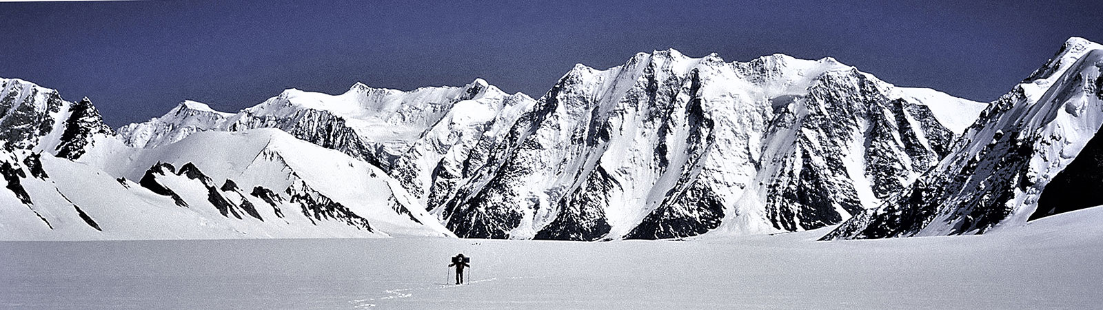
Once we’d climbed for five hours from the snout of the Siachen, Dr. Longstaff’s valley appeared at a right angle. It was a remarkable sight: about three hundred feet beneath us, through a rift devoid of snow, a tiny, milky stream poured through a vast grey valley into the Siachen, a rare example of a stream draining three major glaciers and then flowing into another large glacier.
We continued laboriously up the Terong Valley, stocking camps and weaving around ice penitents, covering seven or eight kilometres per day. On the second day, Stephen Venables, wearing a green jacket—the color of the Indian and Pakistani army jackets—walked silently behind our Ladakhi porters. Until then, the porters had gone ahead with loads from base camp, and they hadn’t yet encountered any of the British climbers. Confused, the Ladakhis tried to speak to him; Venables didn’t understand a word. Taking him to be a Pakistani spy, all twenty porters threw down their loads and fled—we were in a war zone after all.
With the remaining three porters from Uttarakhand, we kept ferrying loads, sometimes making two trips a day. After three camps on the glacier, there was still no sign of Rimo. The unclear contours of the old maps didn’t help, with the wrong locations marked for peaks and valleys. As we crossed many walls of ice and rubble, our progress became arduous and slow. Finally, on the fourth day, we paused: a magnificent high peak rose at the head of the valley. “It is wonderful; red granite; a terrifying steep buttress,” someone said. “It is a chandelle like the Frêney Pillar,” said another. And, finally: “This must be one of the hardest unclimbed 7000-meter peaks.”
Rimo stands amid a group of mountains numbered I to IV, each above 7000 meters and all at the time unclimbed—the main summit is Rimo I. Our days began with the sound of artillery firing on the main Siachen Glacier, about two kilometers distant. The guns faced westward, away from us and into the Pakistan-held valleys. It was surreal to hear the muted boom-boom-boom across the solitude of the colossal glacier—we called it “Good Morning, Siachen.” We broke into smaller teams and fanned out into the many branches of the Terong Valley, exploring glaciers, passes and high cols. At first we climbed several smaller peaks—smaller by Himalayan standards, though each was about 6000 meters, unknown and unnamed. We travelled the long South Terong Glacier for the first time to reach the Terong Col, which links the Siachen Valley with the eastern valleys. Two of our members crossed the Ibex Col, to make the first ascent of Rimo III from the east.
A sense of wonder filled me as we moved across unknown ground, using only intuition and experience to navigate. All around us were iridescent glacial lakes, fragile snow bridges, glistening ice walls and sharp penitentes. A few wild roses grew on the sides of the glacier, justifying the name Siachen (sia means “rose,” and chen means “the place of” in Balti).
Venables and Victor Saunders attempted a daring line on the southwest face of Rimo I, making camps at small intervals on precarious ledges. The route started with a steep wall and rose through a sharp ridge. Crossing several gendarmes, they made slow progress: any slip would have hurtled them thousands of feet down the face. As they approached the higher reaches, a grand view of the Karakoram opened up—including the pyramid of K2 and the sheer gold rock face of Saltoro Kangri II (7705m), perhaps the highest unclimbed peak in the world today. Nearer was the vast Teram Shehr (“destroyed city”) plateau, a unique tableland at about 5000 meters that runs for miles and is ringed on three sides by shining white peaks.
On the sixth day, Saunders-Venables reached 6850 meters, tantalizingly close to the summit. It was late evening when the tired party started excavating a tent platform. To his horror, Venables saw his rucksack slide down the slope and fall a thousand meters into the western cwm. Evidently, he had not clipped it to the anchor. With it went his gear, including his sleeping bag, duvet, food, tent poles, and most vitally, the gas stove to melt snow. Going to the summit was now an impossible dream. To proceed without equipment would have been suicidal.
After an uncomfortable night in a pole-less tent, they descended with great care. Venables was upset, but nothing could be done except to look for the fallen rucksack when they returned to the valley down the steep northwest face. They found the rucksack in tatters, the equipment strewn across a large area. For three more years, Rimo I remained unclimbed.
At last in 1988, an Indo-Japanese team made its first ascent via the south face from Ibex Col, fixing hundreds of meters of rope. But the challenging line on the southwest face still awaits. The southwest face of Rimo III has defeated three expeditions and likewise remains unclimbed. There are several more glaciers to explore and peaks to climb in the Terong Valley. Both Rimo routes would pose some of the finest challenges for any mountaineer.
As we returned to civilization in 1985, headlines flashed in the Indian and British press about a British alpinist dropping his rucksack from high on Rimo. In a way, this news announced to the world that India now controlled the Siachen Glacier. Today, climbers must seek India’s permission to visit the Terong —a fact accidently proclaimed by a moment’s careless fumble and by a rucksack tumbling over and over until it vanished in the crystalline air.
Epilogue: A Dream of Roses
“We are patriotic soldiers and will fight for the country to protect the Siachen Glacier,” a young army officer once said to my son Nawang and myself. “But we do not want our children and grandchildren to sit on this forlorn glacier to defend it. Enough blood has flowed here…. Look at the glacier, once a pristine mountain area. Now due to the war it is polluted possibly beyond repair. Something must be done to find a solution to this war and allow the glacier to rejuvenate.”
Nawang later joined the Indian army. Fifteen years after my expedition to Rimo, he was killed in action in the Kashmir war. In his memory, I decided to work on a proposal for a “Siachen Peace Park,” under which armies can withdraw and allow the glacier to recover. There are many such parks under the aegis of the IUCN (International Union for Conservation of Nature) supported by numerous countries. The proposal, known in political and army circles in India, is moving slowly due to the troubled relationship between the Indian and Pakistani governments. Let us hope that the dream of peace will become a reality someday. This is the best chance for the Siachen roses to grow again