Exploring Teram Shehr Plateau
Share on Social
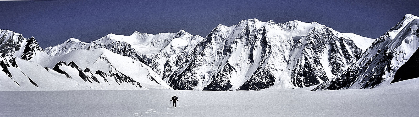
ON THE SIACHEN GLACIER, 1998
HARISH KAPADIA
How many deaths will it take till he knows
that too many people have died?
The answer my friend,
is blowing in the wind.
The answer is blowing in the wind.
(Bob Dylan)
The Siachen glacier, 72 km, in the East Karakoram is one of the longest glaciers in the Himalaya and Karakoram. It has number of peaks, side valleys and at its head lies the Indira Col, the divide between South and Central Asia. The Nubra river drains the glacier and ultimately joins the Shyok river near Khalsar. On the west lies the West Karakoram (now under Pakistani control) and towards the east is the Shyok basin, forming the border with China. The northern slopes of the Indira Ridge leads to the Shaksgam valley. The Siachen glacier was not much visited by the mountaineers in the recent years due to the on going conflict on its heights between India and Pakistan.
In the 1970s and early eighties Pakistan permitted several mountaineering expeditions to climb high peaks on this glacier. This was to reinforce their claim on the area as these expeditions arrived on the glacier with a permit obtained from the Government of Pakistan. In many cases an liaison officer from the Pakistan army accompanied the team. Mountaineers by their climbing activities here, thus played a different role in history of the glacier. In 1984, when the Indian army positioned itself on the heights of the Siachen glacier, the Government of India as a policy decided to encourage mountaineering expeditions to this glacier from the Indian territory to counter the Pakistani policies of the past. Expeditions consisting of Indian mountaineers or joint expeditions with foreign mountaineers were to be allowed to climb on the Siachen glacier. However after 1988 no expeditions visited the upper glacier. We came to the glacier in 1996 but were turned back suddenly
ROSE EXPEDITION 1998
We, mountaineers from Bombay, applied to climb on this glacier in 1998. After due consideration for six months permits were granted. Finally on the 22nd June 1998 the entire team of six Indian mountaineers was in Leh. We spent two days in Leh to acclimatise and arrange the final clearance from the army. Travelling to the Nubra valley the team stayed four days at Tigur village for acclimatisation. The Brigade headquarters at Partapur was visited twice to tie up all the final details. On the 30th June we moved to the army base camp. Our liaison officer, Capt. Ashish Suhag with our member Divyesh Muni joined us here completing the team. No local porters were available as most of the Ladakhi population had gone to Changthang to hear the sermon of the Dalai Lama, who was visiting the area. So we decided to ferry the loads between camps with our available strength. The army was most helpful and agreed to shift rations and kerosene to middle of the glacier by helicopters and agreed to provide food at intermediate camps. By 3rd July we were ready to move up the glacier with 8 Sherpas as support, having arranged about our food and equipment.
We were treading on the historical ground . It was a great feeling moving up the glacier once again. Soon we passed the entrance to the Terong valley in the east. We were familiar with this valley, having explored it thoroughly in 1985 and again in 1996. Many memories were recalled. We stayed at the northerly turn of glacier. Several peaks rose in the south and east while in the west we saw the Gyong la valley which led to the famous pass of the same name. Many expeditions had come up to the Siachen by this pass from Gyong valley in the west. Next 7 days we slowly built up the supplies moving our equipment and specialised food up the glacier over 3 camps. These camps were on the moraines as the snow had melted by now. We were camping on rocky grounds everywhere. After the third day several groups of peaks rose in the northeast. We saw the massive Singhi Kangri (7751 m), justifying its name (Singhi = difficult). In the same group was Afraj (6815 m) (‘one who rises others’, Khan Sahib Afraj Gul was an Indian Surveyor who visited the area in 1935 with the Visser expedition and had named several peaks in the area. We decided to name this central peak of the glacier after him). From the middle of the glacier the view as stupendous. In one sweep we could see the upper Siachen glacier leading to India Saddle and Indira Col (name Indira Col was given by Bullock-Workman in 1912 after Goddess Laxmi. It has no connection with Mrs. Indira Gandhi, who was Prime Minister of India when the Indian army started action on the glacier). In the east rose the gentle Teram Shehr glacier with Junction peak rising from the only green meadow on the edge of the glacier. On our immediate east rose the peaks at the edge of the Teram Shehr Plateau. Bullock-Workman had named one of the peaks as Laxmi (wife of Vishnu and goddess of wealth). As Lord Vishnu is God of preservation we chose to give names of Vishnu to some of the peaks on the Teram Shehr Plateau, like Padmanabh (7030 m) to the highest peak on the plateau. This plateau, Teram Shehr, means a ‘destroyed city’ (based on a Balti legend). It is hoped that Vishnu will protect and prevent any further destruction.
A team was to reach Col Italia on the head of the Teram Shehr glacier. But the prevailing situation of the war did not make it feasible to cross to the Teram Shehr glacier. Throughout our stay we were always aware that this is a war-zone. There were daily artillery firings across and above our route, helicopters were flying and we met soldiers on their way down, tired and haggard. It is a very different playground for the mountaineers.
To Indira Col
The glacier ahead was completely snow-bound even during peak of the summer months. Almost 30 to 40 ft of snow covers the entire glacier in winter and cold intensifies to below 40 degrees C. We were visiting the glacier during best time of the year and to the easiest part of the glacier. Still the cold and difficulties were evident. The glacier flattens out ahead of the centre of the glacier. Soon we passed a side-entrant leading to Bilafond la (‘butterfly shaped glacier’) in the west. This was the Lolofond glacier (named after Dr Tom Longstaff). It was small and flat and joined the Siachen after a small expanse . The historic peak of Tawiz (6400 m) was dominating the sky. To the northwest another historic peak rose its head, Hawk (6754 m). This peak was to remain as a flag pole with us throughout now onwards on the glacier. The great site of Saltoro Kangri peaks (7742 and 7705 m) rising on the Peak 36 glacier was unforgettable. Sheer size and difficulties of rock walls on its slopes makes it a great objective. Today Saltoro Kangri II (7705 m) is one of the highest unclimbed peaks in the world.
After further four camps we were nearing the head of the glacier. There were not many difficulties, except for few crevasses. We walked short marches in excellent weather. Soon we passed another valley in the west leading to Sia La and Convey Saddle, both historic places. The Siachen glacier was still very broad and on its eastern edge rose two shapely pinnacles (Staghar Towers I and II), There was a deep notch to its south. This was Staghar Pass through which the Japanese expedition had crossed to the east to make the first ascent of Singhi Kangri. Soon we were nearing our goals. Sia Kangri I (7422 m) and II (7092 m) (formerly known as Hardinge) were near. Their stupendous walls were threatening avalanches and all camps were placed carefully away from them. Our last camp on the glacier was little above the ‘Ridge Camp’ of Bullock-Workman in 1912.
First we decided to reach Turkestan La (East) (5810 m). It lay on the head of an eastern valley. On 20th July 1998 four of us with LO and a Sherpa left by 6.30 a.m. Winding a way through crevasse and going up a gentle valley, we were at the la in 2 hours, overlooking the Staghar glacier. The eastern slopes gently led down to the glacier and ice-penitents of the Staghar glacier were clearly seen. The view in the south included several peaks around the Singhi Kangri ridge, with Staghar Pass clearly visible. One could admire the tenacity of the Japanese team in 1976 to have crossed Bilafond la and Staghar Pass to ultimately climb the steep and sharp ridge of Singhi Kangri.
The ridge, on which we were standing, rose gently towards north and a deep notch was seen on it. This was the Turkestan La (North) which was reached by Col. Francis Younghusband (later Sir) in 1889. It is sometimes fondly called ‘Colonel’s Col’. Discussing the locations with the army, we found that there was much confusion about names, heights and location of the passes and cols on the Indira ridge. This is a long ridge leading from foot of Sia Kangri to ‘Colonel’s Col’ and turning south to Turkestan La (East). This is the northernmost ridge of India at present and it forms a major divide between South and Central Asia. It is essential to clearly note the exact locations of cols on this ridge.
The Indira Ridge
- The main Indira Col (west) is located at the foot of the eastern ridge descending from Sia Kangri. It is here, exactly, the heads of the Siachen and Urdok glaciers meet. This col was recorded to have been reached by Col. N. Kumar’s team in 1981 and again by the Americans in 1986. The northern sections from this Col are overhanging and it is not possible to descend in the north from here or from India Saddle.
- On the same ridge a point of 6000 m is erroneously marked on the present map as ‘Indira Col’. It is a steep saddle and by no imagination can be called a ‘col’ (Col is the lowest point on a ridge). It is not known how and when this point came to be associated as ‘Indira col’ and who reached it first. But at present all the teams from the army and others reach this Saddle. We propose to call this point as ‘India Saddle’. It is the northernmost point of India at present (being few “seconds” further north of the true Indira Col (West).
- On the ridge further east lies the Indira Col (East) which was reached by Bullock-Workman expedition in 1912. This col is located on the head of a minor valley rising from the Siachen glacier. It is possible to descend to the north from this col into a side valley of the Urdok glacier.
- The easternmost pass on this ridge is Turkestan La (North). It is an easy pass on both the sides and this was reached in 1889 by Col. Younghusband.
- The ridge turns south from here. Little to the south Turkestan La (East) is located.
Reaching the Northern Points
On 22nd July 1998 we started at 6.30 a.m. and walked northwards on crisp snow and gently rising glacier. After turning the peak Faiz (6150 m) (‘one who is at the top’) a wide bowl opened in front of us. We were faced with the Indira Ridge and a vast panorama. To north was the Indira Col (West) (the main Indira Col). I decided to reach this Col with Sherpa Pemba Tsering. After a walk of about 2 hours we were at the pass. At the pass we made a safe anchor and walked on the northern cornices to safely look down the Urdok glacier. This beautiful flat glacier led northwards to join the Shaksgam river which was visible. Several peaks were visible but unfortunately Gasherbrum I was in clouds. On the north was Chinese Turkestan where trekkers in recent years had roamed freely. Apart from the political divide we were standing on a major geographic divide too. The waters from this col drained in the south to the Siachen glacier, Nubra, Shyok and Indus rivers to merge with the warm waters of Arabian Sea. Waters to the north drained into the Urdok glacier, Shaksgam river, Yarkand river, Tarim and Qyurug rivers to merge with the Lop Nor lake.
Another part of our team, Vijay Kothari, Kaivan Mistry, Vineeta Muni and Capt. Suhag climbed towards the India Saddle. After a steep slope, where they had to use crampons, they stood on the northern-most point of India and enjoyed similar historic moments. We all gathered at the camp by afternoon.
It had taken us walk of 98 kilometres and actual walking for 12 days to reach the Indira Col (it had taken us 20 days in all, including days for ferrying loads and resting). The glacier rose from 3550 m to 5840 m in the mean rise of 1 to 26, in a distance of 72 km (the geographical length of the glacier).
Our party returned to the base in 8 days. The climbing team had already left for Leh. We all could meet back only in Bombay.
First Ascent of Bhujang (6560 m) on the Teram Shehr plateau
(Divyesh Muni narrates)
The main team left for the Indira Col and we descended to Camp 3 to attempt the peak. From 10th to 14th July we built up a base camp across the main Siachen glacier, on its eastern bank. 15 July: Climbing steeply over loose scree and mud slopes.we reached the steep ridge coming down from Bhujang (6560 m). At about 5570 m we reached to a suitable site for a camp. It was a sheltered spot with a grand view of the peaks and glaciers around.
20 July: From 15th to 19th July we had to wait as weather was poor. Sherpas ferried loads one day and on the 18th we two also moved up. But again a day of poor weather intervened. We decided to retrieve the ropes and equipment left at about 6000 m on the mountain. We were within reach of peak 6560 and it would be a pity to go down without giving it an try.
We started early and moved fast, up the mountain. Cyrus and myself front-pointed up the initial 500 m of climb to the point where the ropes and equipment were left. The Sherpas moved up the rock route along the ridge. From this point we studied the route ahead and found a safe passage to traverse onto the col. The route from the col to the top was an easy angled climb over snow with a few patches of ice in-between. We were at the summit by 11.30 a.m. We started down by 12.15 p.m. On the return, we took a long time carefully making our way down the loose rocky ridge back to the summit camp. We reached the camp by 4 p.m. with all our ropes and equipment. Two lengths of fixed ropes had to be left behind on the mountain.
This was the first peak climbed on the Teram Shehr plateau. As this peak rose like a serpent we decided to christen it ‘Bhujang’, the legendary serpent associated with Lord Vishnu.
We moved down the mountain quickly now on and reached the foot of the Siachen glacier by 24th July and travelled to Leh. Waiting for others to return we climbed the ever popular Stok Kangri on 29th July 1998.
A Brief History of the Siachen Glacier
Contrary to the popular belief, the Siachen glacier has been visited by many since more than a Century. The glacier, originally known as ‘Saicher Gharni’ was place of interest and several Baltis from the western valleys visited the glacier. Many decades ago it is believed that a small Yarkandi village existed at the entrance of the Teram Shehr glacier. (Bullock-Workman found the walls of such a settlement in 1912). Here on the glacier Yarkandis met the Baltis and traded with them. Once some of the Yarkandis descended the Ghyari nala and took away a Balti woman with them to their glacier village. To take revenge, Baltis contacted an important mullah, who gave them a tawiz (amulet) which was to be placed on the Bilafond la. Mullah instructed them to return via the Nubra valley. However the Baltis, after placing the tawiz on the pass returned the way they had come. Soon afterwards a great storm visited the Siachen glacier and destroyed the settlements and only the rocky desolation remained. The priests say that the calamity would have been greater had they followed the directions fully. Because of this lapse in following the instructions wild roses were not destroyed by the storm. Today roses grow in plenty near the snout and in the lower valleys. The glacier is called Siachen (Sia-rose, chen-place of) – the place of roses.
First Explorers
For explorers the existence, length and location of the Siachen glacier was a matter of discussions. In 1821, W. Moorcroft passed near its snout and first acknowledged its existence. In 1835 G.T. Vigne approached it from the west trying to reach the Bilafond la, but he never guessed the existence of such a large glacier across the divide. In 1848 Henry Starchy was the first to discover the existence of the ‘Saichar’ glacier and ascended it for two miles from the snout in the Nubra valley. In the same year, Dr. Thomas Thompson also reached the glacier followed by F. Drew in 1849-50. E.C. Ryall of the Survey of India sketched the lower part in 1861. But he ascribed to it a length of only sixteen miles.
During his famous second Karakoram journey in 1889, Sir Francis Younghusband (then Colonel) approached the area over the Urdok valley. He was exploring the area to locate a crossing into the Indian Sub-continent. Following a side valley of the Urdok glacier, he reached Turkestan la (North). Looking down to the Siachen glacier from the north he felt that this was the main axis of the Karakoram. His explorer’s instincts were correct but, in absence of maps, he was not sure where he was standing. His belief was finally confirmed by Dr. T.G. Longstaff in 1909. In fact, it was Dr. Longstaff with Dr. Arthur Névé and Lt Slingsby who were the first real explorers to traverse this great glacier. At first, they crossed over the Bilafond la (or, Saltoro pass, as Dr. Longstaff would have preferred to call it) and named the glacier in the east as ‘Teram Shehr’ (destroyed city) and peaks as Teram Kangri group. After retreating by the same route, he went down the valley and approached the Siachen via the Nubra valley. Dr. Longstaff climbed up from the Siachen snout in the south and observed the same peaks, as he had identified them from Bilafond la. Thus, he conclusively proved the length of Siachen glacier and the actual location of the Turkestan la (North). This was an important discovery as it now established the true boundaries of the Karakoram. What he wrote is quoted often:
Younghusband was a true prophet. Col Burrand of the Survey had suspected the truth. The avalanche-swept pass, whose foot Younghusband had reached 20 years before, was on the main axis of the Karakoram range which thus lay miles farther north than had been believed. We had stolen some 500 sq miles from the Yarkand river systems of Chinese Turkestan, and joined it to the waters of the Indus and the Kingdom of Kashmir.
The Workman Expeditions, 1911 and 1912
The next most important explorers to the Siachen glacier were the famous Workman couple, in 1911-12. Fanny Bullock-Workman and William Hunter Workman were Americans who had special interest in the exploration of the Karakorams. They focused their attention on the exploration of the Siachen glacier.
They entered the glacier crossing over the Bilafond la and camped on the glacier with a large entourage of porters and two Alpine guides. They climbed many peaks and visited almost all the corners of the upper Siachen. Grant Peterkin was a surveyor attached to this expedition. He surveyed the glacier thoroughly and named a few peaks, particularly Teram Kangri, Apsarasas and Ghent. This expedition spent more than two months on the glacier and they visited almost all the major side valleys. Names like Sia la, Junction Peak, Hawk, Tawiz and few others were given by this expedition. They also visited and named Indira Col, after Goddess Laxmi.
Europeans on the glacier
In 1929 Dr. Ph.C. Visser of the Netherlands was on his fourth trip to the Karakoram. They explored the two Terong glaciers and the Shelkar Chorten glacier which were unknown till then. Dr. Rudolf Wyss and surveyor Khan Sahib Afraz Gul stayed in the Terong valley and mapped the area. Thus they completed surveying the lower part of this great glacier.
At the same time, in 1929, the Duke of Spoleto expedition (Italian) crossed the Karakoram by Muztagh pass and reached Turkestan La from north. They descended from Turkestan la (East) after discovering Staghar and Singhi glaciers.
In 1930 Professor Giotto Dainelli completed the survey and exploration of the Siachen Glacier. He reached the glacier from the southern approaches, from the Nubra valley. He established himself at the Teram Shehr glacier junction in early June. He wrote : ‘. . . . thus reaching the Siachen tongue with all my baggage, a caravan of seventy coolies and six and a half tons of food for the men, carried by an additional caravan of ponies and supplementary coolies. On the 9th of June–exactly two months after my departure from Florence–I was heading for my first depot up the glacier. I hope my English colleagues will appreciate this rapidity of execution, which I consider a record!’ Compare this with the present timings. One can reach the snout in 3 days from Delhi without taking a step on foot ! Dainelli, with his only companion Miss Kalau, stayed at the Teram Shehr junction and carried out various geological surveys. Due to the flooding of the Nubra valley in the lower reaches, he could not return by the same route and hence crossed a 6200 m pass to Rimo glaciers in the east. He named this Col Italia (Italy Col). With this, the survey and exploration of the Siachen in major respects was over.
Middle Years and Politics
The Second World War put an end to all climbing activities in this area for a few decades. This was followed by the turmoil of the Indian Independence and the glacier was left alone for a long time. With the India-China War of 1962 in the east of the Siachen glacier, the entire area was now ‘restricted’, even for the Indian mountaineers and no record of any visits exists. It is known that some parties from the Indian security agencies visited Bilafond la.
In the 1971 war Indian troops defeated the Pakistani forces. The Shyok valley in Ladakh was also scene of action. After the war, talks were held in Shimla to sign an agreement about the demarcation of borders. In this “Shimla Agreement”, the ‘Line of Control’ was demarcated till the Shyok river, to what is known as ‘Border Stone NJ 9842’. For the areas to the north of this point, it was agreed that ‘the Line of Control shall follow the lines of the glaciers’. It was not specified which glacier line will be the border. This ambiguity about exact definition of the border is the reason for today’s conflict.
The conflict in the Siachen glacier may not have taken place at all if Mrs. Indira Gandhi has pressurised Zulfikar Ali Bhutto, Prime Minister of Pakistan to sign an agreement demarcating the borders along the Siachen glacier, as it is now. She was advised to do so by the Secretaries. A besieged Bhutto pleaded with Mrs.Gandhi that his word be trusted to do this at a later date, as did not want to come under attack from his military generals. Aap muz par bharosa kijiye, he said. (You must trust me). The ambiguity about the borders was left. But soon maps appeared encompassing the Siachen under Pakistan territory.
To support their claim, from 1972 to 1983, Pakistan promoted and permitted many expeditions on the Siachen glacier. These expeditions generally crossed over either Gyong la, Bilafond la or Sia la to enter the glacier. These expeditions of foreign nationalities were accompanied by Pakistani liaison officers. They climbed many peaks on the glacier. Singhi Kangri, Teram Kangri, Apsarasas, Ghent and Saltoro Kangri I were climbed. Thus mountaineers became political pawns and their climbs, originating from Pakistan created a precedent of its de facto control over the glacier. During this period, three expeditions from the Indian Army climbed on the glacier. The first expedition was in 1978, when a team led by Col. N. Kumar arrived on the glacier and climbed Teram Kangri II. Col. Kumar returned to the glacier in 1981 to climb Saltoro Kangri I with many other peaks. He reached the true Indira Col (west) at the head of the glacier. In between these climbs an army team had climbed Apsarasas.
India Takes Control
By now maps were published in Europe which showed the extended Line of Control to join the Karakoram Pass in the east, thus surreptitiously supporting the Pakistan claim line to the east of the glacier. This would encompass the entire Siachen glacier, conceding it on maps to Pakistan, forming a long common border between Pakistan and China.
Pakistan gave permission to a Japanese expedition to attempt Rimo peak in 1984. This peak is located in the side valley, east of Siachen. It overlooks the eastern areas of the Aksai Chin. Such an expedition would have firmly linked the western routes with the eastern routes, — the trade route leading to Karakoram Pass and China. The Indian army decided to take action and to prevent such an expedition from proceeding.
The first group of the Indian army landed on the glacier on 14th April 1984 to defend the territory and the war on the glacier began, which is still raging today.
Soon the first expedition arrived from India to counter the policy adopted by Pakistan in the past. Next year, in 1985, an Indo-British expedition (led by Harish Kapadia with Dave Wilkinson) was given permission to climb Rimo peak, approaching it from the Nubra valley in India. It became the first civilian expedition to climb on the glacier after starting of the Siachen war, countering any precedents created by climbs initiated from Pakistan. Their successful climb and the international publicity it generated created an awareness of it as an Indian territory. An American team followed in 1986 reaching the Indira Col (West). Since then though a Japanese and British expeditions were allowed to climb in the Terong valley no team entered the main glacier.
After a gap of a decade, in 1996, an Indian team from Bombay, led by Harish Kapadia, arrived on the glacier with all the clearance from the Government of India. At first they climbed in the Terong valley but as they were about to enter the upper glacier they were stopped from proceeding. Someone in the army hierarchy had decided not to allow the team to proceed ahead. They had to return. This reflected rather poorly on the Indian army. However after protests and a critical report, within a year the situation was rectified with change of Commanders. It was decided to allow the Indian mountaineers on the glacier. Thus in 1997 an Indian ladies team (led by Ms. Bachendri Pal) traversed the glacier and stood on India Saddle. The Bombay team, again led by Harish Kapadia, returned to the glacier in 1998 to complete their unfinished venture. They reached Indira Col (West), India Saddle, Turkestan La (East) and climbed the first peak on the Teram Shehr Plateau : Bhujang (6560 m). Indian mountaineers have arrived on the glacier for good.
SUMMARY
Area : The Siachen glacier, East Karakoram.
Members: Harish Kapadia (leader), Vijay Kothari, Cyrus Shroff, Divyesh Muni, Vineeta Muni, and Kaivan Mistry with Captain Ashish Suhag (liaison officer).
Period: From 20th June to 3rd August 1998
An expedition by : The Mountaineers, Bombay.
Result: The expedition approached the Siachen Glacier from its snout. One party reached the Indira Col West, India Saddle and Turkestan La East. Another party made the first ascent of Bhujang (6560 m) on the edge of the Teram Shehr Plateau.
Passes and Peak reached/climbed by the Rose expedition 1998
|
|
Name |
Long. (East) Lat. (North) |
Date Reached |
Members of the Rose expedition 1998, who reached the pass/peak.
|
|
1. |
Turkestan La (East) (5810 m) Traditional pass |
76o 51’ 30” 35o 39’ 00”
|
20th July 1998 |
Harish Kapadia, Kaivan Mistry, Vijay Kothari, Vineeta Muni, Captain Ashish Suhag and Pemba Tsering
|
|
2. |
Indira Col (West) (5840 m)
|
76o 48’ 10” 35o 39’ 40”
|
22nd July 1998 |
Harish Kapadia and Pemba Tsering |
|
3. |
India Saddle (6000 m)
|
76o 48’ 20” 35o 39’ 50” |
22nd July 1998 |
Kaivan Mistry, Vijay Kothari, Vineeta Muni and Captain Ashish Suhag.
|
|
4. |
Bhujang Peak (6560 m) First Ascent |
77o 12’ 00” 35o 24’ 00” |
20th July 1998 |
Divyesh Muni, Cyrus Shroff, Kusang Dorjee, Samgyal, Pasang and Pema Sherpa |