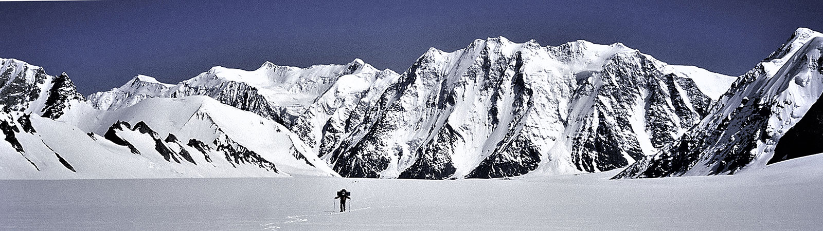
Exploring Teram Shehr Plateau
Share on Social
ARTICLE IN HIMAL , Dec.1998
HIGH STAKES IN SIACHEN
It is commonly believed that prior to the beginning of the conflict in 1984, the Siachen Glacier had been lying in quiet isolation. Given the inhospitable climate of this region, such a belief is understandable, but it is one that is far from true. The glacier has had visitors for a long time, both local and foreign.
In the valleys to the west of the glacier live the Baltis, who have an interesting story to tell about the Siachen Glacier, which they know as Saichar Ghainri. The story goes that there used to be a small Yarkandi village at the entrance of the Teram Shehr Glacier (see map on pg 24), where the Yarkandis met the Baltis for trade. (The Workman couple—more on them below—found the walls of such a settlement in 1912). It so happened that once some of the Yarkandis descended the Ghyari nala and abducted a Balti woman to their glacier village. Desiring revenge, the Baltis sought the help of a famous mullah. Telling them to place it on the Bilafond la (pass), the mullah gave them a tawiz (amulet) whose power would punish the Yarkandis. His instructions to the Balti villagers were to return via the Nubra valley after placing the tawiz. But the latter disregarded the mullah’s instructions and returned the way they had come. Soon a great storm hit the Siachen Glacier and caused great destruction. It is believed the storm would have destroyed everything in the glacier had the mullah’s directions been followed completely.
As it was, the destruction was not total and the wild roses that grow in plenty near the snout of the glacier and in the lower valleys were spared. It is these roses which give the Siachen Glacier its name: Siachen—the Place of Roses (in the Balti language, “sia” is “rose” and “chen” is “place of”).
Beginning with W. Moorcroft, who passed near the glacier’s snout in 1821, the existence, length and location of the Siachen Glacier was a matter of much speculation among Western explorers during the colonial period. In 1848, Henry Starchy became the first Westerner to discover “Saichar Ghainri” (“ghainri” is “glacier” in Balti); he ascended it for two miles from its snout in the Nubra valley. E.C. Ryall of the Survey of India sketched the lower part of the glacier in 1861, and ascribed to it a length of 16 miles.
During his famous second Karakoram journey in 1889, Sir Francis Younghusband (then Colonel Younghusband) approached the area from the Urdok Valley. He was seeking a crossing into the Subcontinent from Central Asia. Following a side valley of the Urdok Glacier, he reached the Turkestan la. Looking down at the Siachen Glacier from the north he felt this pass, and not Bilafond la as it was then believed, was the main axis of the Karakoram. In other words, Younghusband thought that the axis along the Turkestan la (along with the nearby Indira Col) was what separated South Asia from Central Asia.
Defining the actual axis thus meant that several square kilometres of territory would be added to British India at the expense of Chinese Turkestan (now Xinjiang province). Younghusband’s explorer’s instincts were correct, but since this was still uncharted terrain he could not be sure.
Younghusband’s belief was confirmed in 1909 by T.G. Longstaff, who, along with Arthur Neve, and Lieutenant Slingsby, was the first to traverse this great glacier. At first, they crossed over the Bilafond la (or, Saltoro pass, as Longstaff called it then) and named the glacier in the east Teram Shehr (Destroyed City) in keeping with the legend of the mullah which was narrated to them by their Balti porters. The peaks there were named the Teram Kangri group. They then retreated by the same route and went down the valley and approached the Siachen Glacier via the Nubra valley. Longstaff climbed up from the Siachen snout in the south and observed the same peaks as he had identified from the Bilafond la. This was conclusive proof of the length of the Siachen Glacier and the actual location of the Turkestan la—an important discovery as it established the true dimensions of the Karakoram. What he wrote in his book This My Voyage is quoted often:
Younghusband was a true prophet. Col Burrand of the Survey had suspected the truth. The avalanche-swept pass, whose foot Younghusband had reached 20 years before, was on the main axis of the Karakoram range which thus lay miles farther north than had been believed. We had stolen some 500 sq miles from the Yarkand river systems of Chinese Turkestan, and joined it to the waters of the Indus and the Kingdom of Kashmir.
The next important explorers to visit the Siachen Glacier were the famous Workman couple. Fanny Bullock-Workman and William Hunter Workman were Americans who had a special interest in the exploration of the Karakoram, and they focused their attention on the Siachen Glacier in the years 1911 and 1912. Entering via the Bilafond la, the Workmans camped on the glacier with a large entourage of porters and two Alpine guides. This group spent more than two months on the glacier and they climbed many peaks and visited almost all the corners of the upper Siachen. Grant Peterkin, a surveyor attached to this expedition, surveyed the glacier thoroughly and named a few peaks, including Teram Kangri, Apsarasas and Ghent. Names like Sia la, Junction Peak, Hawk, Tawiz and a few others were given by this expedition. It was the Workman expedition which visited and named Indira Col (col=lowest point on a ridge) after the Hindu goddess, Laxmi, one of whose many names is Indira. (The general supposition that this col was christened after Indira Gandhi, prime minister when Indian troops captured the position in 1984, is erroneous.)
In 1929, Dr Ph. C. Visser of the Netherlands, on his fourth trip to the Karakoram, explored the two Terong glaciers and the Shelkar Chorten glacier which were unknown till then. In his group were Rudolf Wyss and Khan Sahib Afraz Gul of the Survey of India, who stayed in the Terong Valley and completed surveying and naming the main peaks in the lower part of this great glacier. In the same year, the Duke of Spoleto expedition (Italian) crossed the Karakoram by the Muztagh pass and reached the Turkestan la from the north. They descended from the Turkestan la after discovering the Staghar and Singhi glaciers.
The survey and exploration of the Siachen was completed a year later by another Italian, Giotto Dainelli. Recounting his journey upto the Teram Shehr glacier junction through the Nubra valley in the Himalayan Journal, Dainalle wrote:
…thus reaching the Siachen tongue with all my baggage, a caravan of seventy coolies and six and a half tons of food for the men, carried by an additional caravan of ponies and supplementary coolies. On the 9th of June—exactly two months after my departure from Florence—I was heading for my first depot up the glacier. I hope my English colleagues will appreciate this rapidity of execution, which I consider a record! (Compare this with present timings—one can reach the glacier’s snout within three days from Delhi without taking even a single step on foot.)
Dainelli, with a Miss Kalau as his only companion, stayed at the Teram Shehr junction and carried out various geological surveys. He could not return by the same route due to flooding of the Nubra valley in the lower reaches, so he crossed over to the Rimo glacier in the east by a 6200 m pass which he named Col Italia.
World War II, and the turmoil of Indian Independence that followed, put an end to all activities in this area for a few decades. With the India-China War of 1962, the entire area became ‘restricted’. Restricted even for Indian climbers, although it is known that some parties from Indian security agencies did visit Bilafond la.
The ambiguity about the exact delineation of the border is behind today’s conflict. The 1949 India-Pakistan agreement demarcated the cease-fire line as extending up to the point known as NJ 9842 near the Shyok River, after which the line moved “thence north to the glaciers”, leaving the boundary vague (see preceding story for details).
The one opportunity to do away with this uncertainty came during the 1972 Shimla talks. It can be safely said that there may not have been any fighting on the Siachen if, during those talks, Indira Gandhi had pressured the Pakistani Prime Minister Zulfikar Ali Bhutto to agree to demarcate the borders along the Saltoro Ridge, as is the situation today. A desperate Bhutto had pleaded with the Indian prime minister that he be trusted to do this at a later date, as he did not want to antagonise his generals. “Aap mujhpe bharosa kijiye (Trust me),” he is reported to have said.
Even as the ambiguity about the line of control remained, however, between 1972 and 1983 Pakistan promoted and permitted many foreign expeditions on the Siachen Glacier. These expeditions, accompanied by Pakistani army liaison officers, generally crossed over the Gyong la, Bilafond la or Sia la to enter the glacier, and climbed many peaks on the
glacier. These climbs set the ground for Pakistan’s claim to the glacier. It has to be noted here that, apart from the ‘political statement’ these expeditions made, the teams were able to make explorations and climbs of the highest order.
During this same period, the Indian army also sent three expeditions to the glacier. Two of these were led by well-known climber Col N. Kumar; these expeditions reached Indira Col and climbed several other peaks, including Saltoro Kangri and Teram Kangri. The fact that these expeditions (1978, 1980 and 1981) took place was made public only in 1983. The Indian government made an attempt to pass them off as mountaineering ventures but their actual intentions were pretty obvious.
However, maps soon began to be published in Europe showing the extended line of control joining the Karakoram Pass in the east following the Pakistani claim. These maps conceded the entire Siachen Glacier to Pakistan, and showed Pakistan and China sharing a long common border to the east of Siachen.
Then in 1984, Pakistan gave permission to a Japanese expedition to attempt Rimo, a peak located in a side valley east of the Siachen and overlooking parts of Aksai Chin. Such an expedition would have linked Pakistan-controlled Kashmir with China, along the historic trade route that leads to Chinese Turkestan over the Karakoram Pass. The Indian army decided to take action to prevent the expedition from proceeding, and thus began the Siachen imbroglio.
Soon after India occupied positions on the glacier, the first Indian mountaineering expedition arrived in the Siachen to counter the policy adopted by Pakistan in the past. The next year, in 1985, an Indo-British expedition (led by this writer with Dave Wilkinson) was given permission to climb Rimo peak, approaching it from the Nubra valley in India. Their success and the international publicity generated created awareness that the area was controlled by India. An American team followed in 1986 and reached the Indira Col.
(There was one more chance for peace over the Siachen Glacier when Gen Zia-ul Haq and Rajiv Gandhi agreed to a cease-fire. Tensions on the glacier eased but not so domestic political tensions, particularly in Pakistan. Benazir Bhutto, then in the opposition, marched the streets with bangles on a plate for Pakistani generals. “Wear these bangles if you cannot fight on the Siachen,” she taunted. Unfortunately for peace in Siachen, Gen Zia was killed in a plane crash in 1988, Benazir came to power the next year and hostilities resumed on the glacier. One of her first official acts was to visit the Pakistani side near the Siachen Glacier. Peace has had no chance after that.)
Mountaineering on the main glacier ceased until 1996, when an Indian team from Bombay, again led by myself, arrived on the glacier with full clearance from the Indian government. The expedition first climbed in the Terong Valley but was not allowed to proceed to the upper glacier. Someone in the army hierarchy had decided not to allow the team to go further. This reflected rather poorly on the Indian army. However, after protests and a critical report, the situation was rectified within a year and it was decided to allow Indian mountaineers on the glacier.
In 1997, an Indian women’s team (led by Bachendri Pal, the first Indian woman to climb Everest) traversed the glacier and stood on India Saddle, a point some seconds north
of Indira Col. And earlier this year, our Bombay team returned to the glacier to complete their unfinished venture. This expedition reached Indira Col West (5840 m), India Saddle (6000 m), Turkestan La (5810 m), and made the first ascent of a peak on the Teram Shehr Plateau, Bhujang (6560 m). The team also named some high peaks on the Teram Shehr Plateau, including one in honour of Khan Sahib Afraz Gul, the Indian surveyor mentioned above. Indian climbers had finally arrived on the glacier.
Rare rose
For the past 14 years, soldiers of the Indian Army have been in the Siachen. The army lives on the glacier under a severe resource crunch. Supplies are taken up by helicopter but there is always a shortage of air transport, sometimes even to bring down the injured. Under such circumstances it is hardly surprising that the glacier is under severe environmental strain.
Much of the garbage is put into crevasses or dumped on rocks and snow. In winter, all this is covered under a thick layer of snow and the entire area appears like a beautiful white sheet. But come summer, all the cans, drums and human waste come to the surface and litter is seen everywhere. The worst offenders are the tetrapacks in which fruit juices are delivered on the glacier. These aluminium packs, which cannot be burnt or destroyed, line the routes which are traversed by the army and are a major eye-sore. The army cannot burn the garbage on the glacier, and neither can it destroy it there, much less bring it down.
The weather pattern in the entire area of Ladakh and the East Karakoram is also changing; whether it has anything to do with the ongoing war in Siachen cannot be ascertained yet. The East Karakoram is no longer a rain shadow area and receives several inches of rainfall. The Siachen Glacier snout itself has receded by about 800 metres in the last 13 years. The glacier looked barren and without snow cover during our 1998 expedition. The Terong glaciers, particularly the North Terong Glacier seemed to be receding fast and most of the ice-penitents and lakes had disappeared during the last decade. Icefalls in the Safina Valley (which we had crossed in 1985) and the Shelkar Chorten Valley seemed more broken and difficult.
The rose plants, too, have suffered. Many were cut and their stems used as decorative pieces and even as tent-pegs. After I drew the army’s attention to this destruction, the military authorities gave assurances that the rose plants would henceforth be declared a rare species and no harm would be done to them. When this happens it could set the stage for full environmental protection of the glacier.
Some serious thinking about the environmental concerns on the Siachen Glacier needs to be done. The war has taken a heavy toll of men and material on both sides. It is an impasse in which no side seems to be gaining. Soldiers face each other, both sides have artillery (though the rarefied atmosphere makes nonsense of ballistic data), millions of rupees are spent daily to maintain these forces where causalities due to the altitude and cold are nine times higher than those due to combat (an estimated USD 2 million is spent daily by the two armies on the glacier).
Perhaps the time has come to end such a stalemate. A possible solution was mooted in the Himalayan Journal in 1993 by Aamir Ali, an Indian living in Geneva: persuade India and Pakistan to withdraw their armies and establish an “International Park of the Rose”. Such a park can be placed under the guardianship of the United Nations and the International Union of Alpine Associations, or, by including the territory held by Pakistan, it can be administered jointly by India and Pakistan as a transnational park. But this is a matter for the governments of India and Pakistan to consider. As a mountaineer and lover of this glacier I can only hope that steps are taken soon to conclude this never-ending war and save the beautiful Siachen.
The mullah, whose tawiz which destroyed the glacier in the first instance, had made another prediction: if, due to human folly, the storm did not cause total destruction of the glacier, another ‘storm’ may visit the glacier in a century to complete the job. This war seems to be fulfilling his prediction.
Bombay-based mountaineer H. Kapadia is Honorary Editor of the Himalayan Journal and author of several books on the Himalaya. He is at present working on a book on the Siachen Glacier, among other projects about his Himalayan experiences.