Tung fort and Pawna lake
Share on Social
TREK THE SAHYADRIS
The Western Ghats are a major mountain range of India and are well known for its flora, fauna and mountain tops. This long range runs parallel to the Arabian Sea and form a long wall which gathers to itself monsoon cloudes and has much thick forest. The range runs from Narmada river in the north to almost tip of Kanya Kumari. The northern part of this range, from Surat to Goa is called the Sahyadri. This range is most visited part by trekkers as it is easily approachable by people from cities of Mumbai, Pune and others.
Trekking in the Sahyadris has its own charms – it is endowed with numerous delightful routes – both easy and difficult, that provide countless avenues to trekkers of all levels. And what comes as the icing on the cake is the tremendous opportunity to discover the rich cultural heritage of India, as most of the spots have both cultural and mythological background and famous tales of heroism associated with them. And last but not the least, is the opportunity inherent in any trekking or hiking excursion – to come closer to the mother nature and experience her bounty in terms of the flora and fauna, first hand.
The northern-most tip of the Sahyadris lie in the Nashik-Satna region of Maharashtra, bordering the Dangs district of Gujarat. The town of Satna forms an ideal base for various trekking destinations in the region. Here the destinations lie either in the Selbari Ranges, to the northwest of the town or the Ajanta-Satmala Ranges in the south.
Starting in the northeastern end of the Selbari Range, we start with a twin pinnacled peak – Mangi-Tungi (1329 m) which has several Jain temples both at its bottom and on its summit. It is visited often by pilgrims. But the highlight of this range is the Salher Fort, which is the highest fort of Sahyadris and the second highest point – 1567 m of the Sahyadris (after Kalsubai – 1647 m in the Igatpuri region). There is a huge cave and water cisterns just below the top. The route, which starts from Vaghambe village through the fields and though it involves lot of physical effort and planning but the trek is very worthwhile. On its east, Salher is flanked by another fort called Salota. From here a ridge, called Panch Pandav as it has five humps, leads to an ancient fort of Mulher. It is composite fort with two fortified peaks – Hargad and Auranggad; the complex also contains a pond and many ruins and it speaks of history of wars during Mughal times.
To the south of Satna and nothwest of Nashik lies the Ajanta-Satmala or Chandwad range. It runs east-west for about 80 km after branching from the main Sahyadri range. To its extreme eastern edge lies the Chandwad Fort near which the Malegam-Nashik highway cuts across this range. Though the climb is not very difficult but the last 15 metres to the top of the fort requires rope to climb the steep rock face. While travelling west from here we come across many trekking spots like Indrai Killa, Rajdher, Kachna and Ikhara till we reach Dhodap (1451 m) – which is a very prominent fort on a pyramidal shaped hill seen from both road and rail. The trek to this spot starts from Dhodambe village which can be reached from Nashik by road. After a long walk to the top you find fascinating caves and a pond waiting for you. To climb the final 70 metres of the rock pyramid you need to display your rock climbing skills. A gap has also been excavated on the western side on its long ridge, which was used to throw the condemned prisoners during times of rule by Shivaji.
If you are rock climb fanatic then Ikhara pinnacle to the east of Dhodap and the twins – Taula and Achala on the west will test your skills. But if you want test of endurance then proceed to Saptashringi (1416 m), lying just before twin peaks of Taula and Achala. Another prominent peak is Hatgad, an easy walk up. It is lying little north of this range and can be approached from the Hatgad village below connected by road from Nashik through Vani.
Igatpuri region lying south of the Nashik-Satna region is as exciting. The highlight of the region is its beautiful countryside with numerous lakes scattered all over the place, its highest of peaks and remotely placed hill forts posing challenge to the avid rock-climbers. Among other highlights we also have Vaitarna Lake one of the main sources of drinking water to Mumbai; the railway line and road going to Mumbai passing through the Sahyadris at Thal Ghat between Igatpuri and Kasara.
Igatpuri, which can be easily reached from Mumbai, forms the hub of most of the trekking expeditions in the region from where one get to various starting points easily. (If you are coming to this region from Mumbai then more than a day’s trek should be planned).
Trimbak range lies north of Igatpuri and the highlight of the region is the Trimbakeshwar temple – origin of river Godavari and one of the most sacred sites of Hindus ( as it is one of the twelve jyotirlingams i.e. abodes of Shiva according to the Rudra-Samhita); It can also be easily approached from Nashik by road.
Trimbakeshwar hill nearby has a grassy top with temple which can be easily approached from the base by steps (around 700). This hill was used as a fort since ancient times. Other worth trekking peaks nearby are Anjaneri (1,300 m), Harihar (1,120 m) and Fani Dongar (992 m). Out of these Harihar is a fort which is built on a three-faced rock, out of which two faces are completely vertical; and the third face is inclined at 75º. An excavated staircase leads to the top where there is a temple and a watery cave.
After Trimbak range the crest of Sahyadri up to Thal Ghat, is conspicuous by an absence of any high peaks. Kalsubai Peak, the highest peak of northern Sahyadris at 1646 m, lies in the range branching off in the north-easterly direction from the main crest south of Thal Ghat. This range starts with two difficult hill-forts of Alang and Madangad. Both these forts require technical equipments and specialised training to complete the climb. Their adjoining hill, Kulangad, has many steps leading to its summit and has the highest climb from base to the summit anywhere in the Sahyadris.
Further on the range you have Kalsubai, the queen of Sahyadris, which commands a fantastic view of the distant peaks and is climbable by a trekker of any level. Further northeast passing through peaks like Pandhra (1450 m), Bitangad (1100 m) and Mahankal you reach Patta Fort (1390 m). Patta is a most interesting fort with a flat plateau on top. The weather on it is very pleasant – even in summers. The top has water cisterns and caves and a hall. Further up at the end of this range is a huge rock massif of Avandh (1319 m) and gentle treks of Aad (1233 m) and Mhasoba (1273 m).
Further continuing along the Sahyadris one reaches most rugged and inaccessible of all regions – Malshej Region. With its two main passes of Malshej and Nane Ghat it was once a strategically very important region as it connected the ancient ports of Kalyan and Nalasopara (Caliyan and Sopara or Sopatma of ancient times) with the ancient cities of Paithan (capital of Satvahanas) and Junnar on its east. Due to this it has a high density of many famous forts including that of Shivneri where Shivaji was born. Junnar forms the hub of this region for starting the trails.
Harishchandragad (1424 m) is a massive fort, north of Malshej Ghat and has a large flat top with several caves, a temple and many other features. On its north-western side is Konkan Kada a massive cliff of 400 metres. Actual top is further 100 m up and commands the view of Nane Ghat region. Further south is Nane Ghat valley with important forts of Hadsar, Chavand and Shivneri guarding it. Shivneri Fort (1018 m) on a triangular hill which is 3 km from Junnar can be easily climbed. It houses many buildings of historical interest. Hadsar (1428 m) and Chavand (1065 m) forts are now in ruins and they are also meant to be climbed by trekkers of all levels and in case of Chavand a series of rock steps lead to the top. The base of all these forts are well connected from Junnar. The Nane Ghat pass is a sheer cliff very clearly visible from Konkan region; its walls command a good view of all the major peaks all around the region.
Further down in the Ghori river valley we have a huge plateau of Narayangad which gives a view of Mina river valley to its north and Ghori river valley to its south. If you cross west the Sahyadris from Ahupe Ghat you can see the Gorakhgad and Machhindragad pinnacles which can be a good challenge to rock climbers. Further south is a prominent square massif called Siddhagad.
South and southwest of Malshej region is the Karjat-Matheran Region and further south is the Lonavla-Khandala Region. Karjat-Matheran Region is the nearest trekking destination from Mumbai and hence receives highest trekking traffic. Most of the starting points are well connected and treks can be easily completed in one day. In the Thane Area you have Parsik Ranges near Mumbra Railway Station. These offer excellent opportunity for those who want to take up rock-climbing but it should be pursued only if you have all the training and equipments.
Matheran Range lies to the west of the main Sahyadri Range, named after the famous hill station near Mumbai – Matheran. Matheran (767 m) is connected by both the motorable road and the rail from the Neral Station on the main route. To the north lies the Nakhind hill (704 m) known for its gentle slope and a dargah in the middle of the hill. After reaching the top you can further trek to the Peb Fort (474 m) with its grassy top. Further north lies Mhasmal, which is a group of four peaks and extremely difficult to climb.
South of Matheran lies a very short range just north of Chowk village with Irshal hill (370 m) with sharp ridges giving an extreme challenge to any rock climber. Another highlight in the range is Prabal Plateau(707 m) which is easier to climb and has a forested top.
The Karjat area lies south and west of Malshej Ghat Region. It is start is marked by the famous pilgrimage spot of Bhimashankar (1005 m) which is another Jyotirling of Shiva in the Sahyadris and the starting point of the river Bhima, a tributary of Godavari. It has a beautiful temple on its top with a huge bell. It is very well connected from Mumbai and Pune by road. Further south on the range is the Dhak plateau (707 m) which is a huge flat-topped hill detached from the main range. It is easily approachable from Karjat. Further south along the ghats lies twin peaks of Rajmachi forts; from here you can easily catch a glimpse of the Shirota Lake on its east. Rajmachi fort lies 10 km north of Khandala railway station. Hence this marks the start of the Lonavla-Khandala Region.
This region contains the famous Bhor Ghat through which the Mumbai-Pune route passes. In olden times the Rajmachi fort along with other forts guarded the Bhor Ghat pass. Bhor Ghat lying to the west of Khandala gives you a very good view of the Khopoli town below in the plains. From Lonavala a road leads to Karla Caves of Buddhist era. It can be also approached from Malavali Station.
Near Lonavla a subsidiary range called Mandavi branches off eastwards; on it lie two famous forts – Lohagad and Visapur guarding the approach to Pune. Malavali which is the next station from Lonavla leads to the Bhaja caves which was once a Buddhist monastery. These caves lie at the base of the Visapur and Lohagad from where trek for both these forts start. Visapur (1087 m), though more recent than Lohagad, is both higher and larger than Lohagad. Both these forts have lot of history associated with them. They offer a fantastic view of the valley below and during the monsoon are covered by clouds which give it a majestic look.
Further east on the Mandavi Range lie Bedse Caves which belong to the Buddhist period like Bhaja and Karla Caves. It is easily approached from Kamshet Station while going towards which forms Pawna Lake. On this road lies Tikona Peth village from where the trek starts for Tikona fort (1091m). As the name suggests this is a fort lying on a triangular hill. The trek is easy and there is a lake on the top. The same road as above further leads to a col between Tikona and Mandavi Dongar from where the trek to the latter can be attempted.
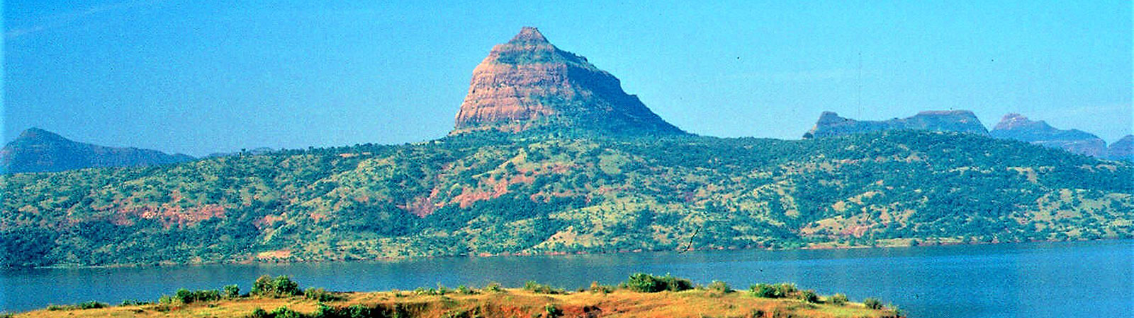
South of Lonavala lies a vast plateau called Paun-Maval. This contains many interesting destinations. The plateau starts near Duke’s Nose and goes up till Mulshi Lake. Duke’s Nose is a prominent projection in Sahyadris south of Bhor Ghat, approachable from Khandala. Bushy Dam lies south of Lonavala at the start of Mandavi Range, and is owned by the Railways. Further south lie Korigad and Tung fortresses. Korigad (929 m) can be reached from Lonavala by taking the road going south for Ambavne from where the trek starts. Korigad has a flat top with few ponds and ruins of a temple. It offers a good view of Mulshi Lake. (This lake was formed because of Mulshi Hydro-electric Dam; this dam is a popular spot for hikers from Pune). Another fort called Tung is situated nearby. It is surrounded on three sides by the Pawna Lake and can be approached from either the col between Lohagad and Visapur in its north or from Pawna Dam on its east; both of the routes will require oneself to be ferried across Pawna Lake in a boat to the base of the fort. The hill itself is oblong in shape and once used to control the route to Pune and serve as a frontier post to the Lohagad fort. Sudhagad is a fort that lies further west of the main Sahyadri ghats. It is very well preserved fort with a big plateau on the top. To reach Sudhagad one has to take the same route to the base of Korigad and from there get down to Konkan plains via Wasri Pass to Bhairampada; from here follow a nala to the top. South of this fort the Sahyadris wind their way into the Pune Region.
Pune Region is the region where Shivaji spent his early days and which shaped his personality much. Hence, in each trek much history is hidden. Bhuleshwar range is a side range of the Sahyadris which emanates eastwards little to the south of the latitude of Pune. This range further branches into northern and southern branches. In the middle of the northern branch lies the Sinhgad fort (1317 m). This fort lies 26 km southwest of Pune city near National Defence Academy in Khadakvasla. The most popular point to start the trek is Donaje at the base of the fort. Other treks like the one from the steeper side called Tanaji cliff are only meant for professionals. From the top of Sinhgad you can get a very good view of the of the other forts around. Samadhi of Tanaji and Lokmanya Tilak’s cottage are some of the historic sites on the top.
On the southern branch of Bhuleshwar range you have important forts of Rajgad and Torna. Rajgad (1376 m) served as the capital of Shivaji for 25 years of his life, before he moved it to Raigad. It lies 40 km southwest of Pune and is very well fortified – 8 km of surrounding curtain wall and three spurs have been converted into three very well fortified machis. With the central top known as Bale Killa, the fort is truly a marvel of construction and a product of Shivaji’s genius. The trek can be started from either Margsani or Vinzar both lying on the road to Welhe from Pune and then proceed towards the fort after crossing the Gunjavni River. Another of Shivaji’s fort called Torna (1403 m) lies 6 km west of Rajgad. For going to Torna one must reach Welhe by road from Pune and from there it is two hours of exciting climb.
Two more important forts lie nearby – Purandhar and Raigad. Purandhar lies at the end of the range that runs south-eastwards from Sinhgad. It is a strong fort that witnessed great battles in the Maratha history. It can be very easily reached by road from Pune which is 26 km from here. Raigad lies on a range separated by a ravine form the main range, to the west of the point where Bhuleshwar range starts. It was here that Shivaji was crowned. It was a safe residence as the natural defences offered by way of almost vertical scarps were further strengthened by ramparts and bastions. It commands an excellent view and it enabled Shivaji to easily control the Javli-Mahad area, right up to the sea. It can be trekked from Pachad reached via Mahad by road. In present days it is very crowded and a ropeway leads to its top.
The Sahyadris swerve and flex their way further south and reach the Bhor area with its hub in the Bhor town, south of Pune. Here Vichitragad or Rohida (1116 m) is a small fort whose base can be reached from Bhor after covering a distance of 6 kms by road. Another fort of the region is Kangori or Mangalgad (774 m) which is 17 km from Mahabaleshwar in aerial distance. It was captured by Shivaji in 1648. It stands little off the ghat line, guarding the Varandha, Bhope and Kamtha ghats. Probably it also served as a link fort between Raigad and Pratapgad. You can take a diversion from Varandha village on the Bhor-Mahad road and via Kiye and Gothaoli villages reach the base. South of Bhor town, while going to Mahabaleshwar from Pune lies Wai area. Walki and Krishna rivers rise in this area and a dam called Dhom is built across them forming the Dhom Lake. Pandavgad is a small fort near Wai overlooking this dam.
After Wai one enters the Shambhu-Mahadeo ranges of Koyna Region. It contains the hill stations of Mahabaleshwar (1438 m ) and Panchgani (1334 m) both of which are flat plateaus with beautiful scenery and pleasant weather. Pratapgad (1080 m ), located near Mahabaleshwar, is well connected and historically very important fort. It was here that Shivaji killed Afzal Khan, the Moghul General. Militarily it was an important fort as it controlled the Ambavani and Pir passes and was one of the strongest fort due to its vertical scarps. Lying south of Shambhu-Mahadeo ranges is the Bamnoli-Ashta ranges in the area around Satara and Karad towns. Very close to Satara city is the formidable fortress Ajinkyatara (also sometimes called Satara fort). It is about 1000 m long running east-west and 500 m in breadth. It was captured by Shivaji in 1673 and by Aurangzeb in 1700. Another fort lies 9 km west of Satara city. It was named Sajjangad by Samarth Ramdas, Shivaji’s Guru after it was captured by Shivaji in 1673. Purali is the nearest road-head at the base of this fort.
This region contains many caves; Agashiv Buddhist Caves are situated in hills southwest of Karad town. From Karad on way to Koynanagar stop at Helwak; from here a trek via Dhangarwada leads to a huge cave complex of Ram Ghal. They have been hidden by a wide gully and have perennial supply of water. South of Koyna valley is the Warna river valley which is very thickly forested and is a treat for nature lovers. The river Warna has been now dammed forming Warna Lake which further protects the isolation of this area.
Panhala range branches off from the main Sahyadris south of Warna river valley. The range starts with the fort Vishalgad and goes up to Panhala fort. Vishalgad is a historic fort protected by scarps, walls and bastions. It has many historic monuments like – samadhi of Ahilyabai and Baji Prabhu, a dargah of Malka Rahman and many other temples. It was captured by Shivaji in 1659. The base of the fort can be reached from Kolhapur (55 kms from here) by road. While going eastwards towards Panhala fort on this range you come across an 11 km long rock plateau called Mhasai Pathar. It is totally barren of any vegetation or habitation and has only a solitary temple. East of Mhasai Pathar is the Panhala fort which is only one hour drive south of Kolhapur town. It is a very large fort with a circumference of 7.25 km and has both natural and man-made defences. Captured in 1654 by Shivaji the fort figured prominently in post-Shivaji succession struggles between Shahu and Tarabai. The Koyna Region is the southern most portion of the Sahyadris, this ends our exciting journey of trekking in the Sahyadris.
A world of natural beauty, and enjoyment lie in this great range. The fun of trekking and the grandeur of the Sahyadris are something to experience. Once you have found a trail in the Sahyadris it will be difficult to keep away.
(From TREK THE SAHYADRIS, a popular guide to the range by Harish Kapadia. It is continually available in print from 1978 till today-2020)