Highest Peaks in Rupshu, Ladakh
Share on Social
Nangpas Are Flying – Changpas Are Smiling
1995
Climbing and Trekking in Southeast Ladakh
At first I was a bit apprehensive about visiting Tso Moriri, recently only opened to tourists. Already there were articles appearing in the press about the environmental degradation taking place at this remote lake in southeast Ladakh. There was talk of fumes from taxis, crass commercialism, and piles of garbage.1 It appeared like even breathing the air there would be polluting it. Environmentalists were recommending a total ban on visitors, after having enjoyed its beauty to their hearts content. ‘Ban them all,’ was their war cry here, like in some other Himalayan areas.
As the fastest growing industry in the world, tourism has touched every part of the globe, and the Himalaya is no exception. Its extraordinary growth has led its detractors to conclude that tourism (and trekking) has ruined many a fine coastline, destroyed unique wilderness areas and wildlife habitats like Tso Moriri, polluted the air and water, uprooted communities, undermined traditional ways of life and corrupted local cultures.
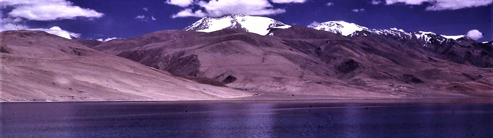
Tso Moriri lake and southeast Ladakh was under wraps for almost 35 years due to ‘inner line’ restrictions and even before that, access was limited because of the difficult terrain. Thus people at the only village on its shore, Karzok,2 lived amidst beauty, without much contact with others, following their nomadic life-style and facing severe winters. In 1994 restrictions were lifted, roads built to reach its shore and it was possible to travel through this area by jeep.3 Suddenly this part of Ladakh became very popular with the jeep-safari travellers, casual visitors as well as serious trekkers and mountaineers. Its beauty, its past remoteness, was an attraction to visitors and used to advantage. Rupshu had arrived at a crossroad in its history. We were visiting it, before the environmentalists had their way.
Remote yes, but the area was not unknown. Several early travellers had visited Karzok, for it lay on the main trail joining Shimla and Spiti with Ladakh. Many had visited this lake and some books mention its charms. Among the early birds here were George Trebeck (1822), H. Strachey (1846) and Thomas Thompson (1847). A.H. Francke, a Morovian missionary commissioned by the British Government visited the lake in 1909 and made a list of all the valuable statues and paintings he saw. F. Drew’s famous book Ladakh gives many scientific facts about the lake.
Surprisingly none of the early travellers mentioned the peaks and mountains of the area. They travelled amidst some of the highest mountains of Ladakh, but besides stating that the mountains existed, not one tried to describe, explore or name them. It was Romesh Bhattacharjee (1984 and 1993) who first wrote about the peaks of the area, explored them and climbed Mentok II. His excellent articles in the Himalayan Journals paved the way for other climbers.4 His 1984 expedition checked several readings about the lake, possibly the next to do so after F. Drew! We certainly owed our inspiration to him.
We flew to Leh, the capital of Ladakh, and acclimatised ourselves there for 3 days, till 30 June 1995. We followed the well-known diktat: ‘Don’t act like Gama in the land of the Lama’5 and took our time to break in gently. To visit and climb around the Tso Moriri lake a permit was required. It was easily acquired from the local authorities. The lake was 221 km away from Leh. The first part of the journey was on a fine black tar road via Upshi (46 km) and Chumathang (76 km) to Mahe bridge (22 km) where the Indus had to be crossed. The rough road ahead turned west to Sumdo (24 km) and then proceeded south across the Namshang la (12 km) to Karzok (31 km), the only village in the area and on the western shore of the lake. Some portions of the road were sandy, requiring a four-wheel drive. There was a small rest house at Karzok for which advance permission had to be obtained from Leh. A branch of the motorable road continued west from Sumdo going over the Pologongka la to the Tso Kar lake. It joined the Leh-Manali road at Debring, covering 70 km from Mahe. This circuit was what the jeep-safari travellers took.
We stayed two days at Karzok visiting the monastery and arranging for donkeys to carry our luggage ahead. On arrival we noticed the two peaks which towered above the eastern shore of the lake. The earlier name suggested for this massif was Thalda Kurmi, but at Karzok no one seemed to have heard of it. The lamas and elders of the village called the higher peak Lungser (the golden mountain) and the other peak Chhamser (the place to worship). These peaks at 6666 m and 6622 m were some of the highest peaks in Ladakh and had never been attempted. A third peak beyond the nala was named Lapgo (the place for prayer).
Karzok was a small village and most of the inhabitants were nomads. During the summer months they camped at various places in their rabos (small tents) and looked after their flock. Their sheep produce the famous pashmina, one of the costliest varieties of wool. Traditional weavers from Kashmir and Himachal buy this wool. The recent boom in its value has led to their prosperity, though that was not evident in their life- style.
Karzok, meaning the ‘middle of the body’ (where the soul resides) or the ‘middle of a mountain’, (where it was located) had an excellent location, overlooking the lake. The monastery at Karzok is ancient. Though no one could tell exactly when it was built, it is believed to be about 500 years old. People as far as Hanle towards the south and up to the Indus in the north followed the teachings of gurus of this gompa. Recently a lama-incarnate had arrived from Darjeeling to head the congre-gation. This young Rimpoche, called ‘Tulku’ locally, was a 6-year old boy who blessed us. A small ‘palace’ was situated next to the monastery. The erstwhile ‘king’ and ‘queen’ worked at the rest house and at the Nyoma weaving centre.
During our stay at Karzok we expected the worst sort of destruction as described by the prophets of environmental doom. But we found nothing more than an occasional jeep arriving with tourists. They camped near the village and visited the monastery and lake. There was no sight of the litter and fumes we’d read about. The Changpa faces lit up with smiles at the sight of the tourists for they meant prosperity. The villagers were using several commercial products whose packaging was carelessly discarded. Perhaps, more than the tourists, it was the villagers who needed to be educated on matters of cleanliness and pollution, on how to handle and use the products, which included bottles and aluminium foil.
Tso Moriri was brought to the notice of the world by the photographers Bedi brothers.6 They stayed by the lake for many months to photograph the nangpas (wild geese) and several other wildlife species, including the snow-leopard. Their use of the motorised boat was rightfully questioned by some but the army has been using such boats on this lake for many years for pleasure. More alarming than both would be to use the lake for water-sports.
In many ways, the Changpas were benefiting from their interaction with modern civilisation. It was changing their life-style, not necessarily for the worse as feared. Till only few years ago they used the lake to dump their garbage and wash themselves in every morning. The quality of their houses and clothes had improved, medical facilities both for men and goats were now available, and transport enabled them to sell their wool at a better price. Some progressive measures were also proposed by the authorities for the future. No houses were allowed to be built within 700 m of the lake and in fact the existing rest house which stood within that limit was to be shifted. Many researchers were working in this unique area, and we met one in Karzok. The advent of civilisation by the new road had allowed tourists to enjoy the beauty of the area and the locals to look forward to enriching their lives.
On the second day, late in the evening, I saw a middle-aged man walking with a horse towards Peldo. I said ‘Jule’ and proceeded to chat. He was Nawang Thondup, the local medicine-man, and he was returning from Karzok after treating a sick lady. He was so gentle that one took an instant liking to him. He agreed to accompany us with some of his donkeys and became our informal guide on both Rupshu, and the terrain. Nawang lived with his flock at Peldo and spent winters near Chumar in south Rupshu. Like all other Changpas he led a nomadic life with his family but had certainly gathered the wisdom of the world by observing people and listening to their travel-lore.
After proper acclimatisation we were ready to climb the mountains. With donkeys provided by a village committee (a sensible system) we started from Karzok on 4 July. We established the base camp at Kurchyu (4915 m) a little above the eastern shore of the lake. This was one of the very few places where drinking water was available. Here the vast expanse of the lake and a wide variety of wildlife was visible. Several phya (marmots) were around and so were some skyangs (wild donkeys). We saw rabbits, fat lizards and at least one pair of bharals. Among the birds, there were ravens who feasted on our rations once at a higher camp, and snow-pigeons, Himala-yan chuff and sparrows were seen many times. The best sight of them all was of brahmani ducks floating effortlessly on the lake with nangpas flying around the lake. There were two pairs of chathungs (black-necked cranes). If something needs to be specially preserved and enjoyed it is this treasure of Rupshu.
Divyesh and Vineeta Muni, with one porter, left for the Lapgo nala as planned. They were to climb on their own. Monesh Devjani decided to leave for Leh and Bombay after the recurrence of an old ankle-ligament injury. For the next two days we recced the area for a site for the advance base camp. We ultimately selected one on the Rungyado phu (5720 m), again the main consideration being the availability of water. Loads were ferried to the advance base camp. A plateau had to be crossed to reach the base of our first peak Chhamser Kangri. After studying the various ridges we decided to attempt the southwest ridge via the Chhamser col. By the 13 July we were ready to attempt the first peak.
Chhamser Kangri (6622 m; 21,725 ft): Second Ascent
On 14 July, five of us (Mistry, Kothari, Harsinh Jr., Kesarsinh and I) left Camp 1 at 7.30 a.m. It was rather cold with a strong breeze blowing. Traversing a steep moraine we reached the beginning of the southern ridge which climbed up to meet a snow-covered slope. This slope led to the southwest ridge. The slope was steep with patches of ice. We put on our crampons and the porters, who were without crampons, were belayed at some places. By 11 a.m. we reached the southwest ridge and found a cairn erected by a khalasi of the Survey of India. We followed the gradually rising southwest ridge from this point onwards. It rose steeply towards the summit in the end. Kothari stopped at this point, about 150 m below the summit. The rest of us reached the summit at 1300 hrs. Again a giant cairn marked the top! These khalasis of the Survey of India seem to have been everywhere, for this was the second high peak that I had climbed where I had found a cairn. The view was stupendous. We could see the Tibetan plateau, the Indus valley and the Tso Moriri lake. We left a flag on the summit cairn and retreated by the same route. It was a tired party that reached Camp 1 at 1600 hrs.
In the meantime, unknown to us, the Muni couple had also decided to attempt Chhamser Kangri the next day from the opposite direction. The two of them had left from a high camp on the morning of 15 July and climbed the northeast ridge. As they approached the summit they were surprised to see not only the cairn, but also a flag! They reached the summit and collected the souvenirs left behind by us. Thus this high peak was climbed by two separate routes, in quick succession, each party oblivious of what the other had been upto.
Lungser Kangri (6666 m; 21,870 ft): First Ascent
Lungser Kangri is the highest peak of the Rupshu area, and the second highest in Mangrik (the vast area of south Ladakh, not including Zanskar). With a view to attempting it we shifted our camp to 6240 m (Camp 2), on 15 July, heading towards the final col leading to the northern ridge of the peak. In the meanwhile, Kothari and Kesarsinh had left for the advance base camp.
On 16 July, four of us (Mistry, Harsinh Sr., Harsinh Jr. and I) left Camp 2 at 6.30 a.m. descending to the Lungser nala and then climbing up to the Lungser pass by 8.30 a.m. Then we followed the northeast slopes which were gentle but crevassed to where they joined the north ridge, at 6400 m. Harsinh Sr. fell into a crevasse but was fortunately held by a rope. Mistry led on the steep ice slope for about 150 m and soon we were on the final summit slope, about 6600 m above sea level. But the task was far from over. The summit plateau kept rising for 1.5 km, the last 60 m testing our strength and patience as each slope rose like a gentle sea-wave. Finally, at 1.30 p.m., we were on the extreme southern end of the plateau which was the true summit. Thank God, no cairn! The views of Ungti, Chumar, the great bend of Pare chu and Hanle were our reward. To the west stretched the expanse of the Tso Moriri lake.
We started descending from the summit at 2 p.m. and with two rappels and a gentle descent on the ridge reached the low point of the Lungser nala by 5 p.m. The climb up to Camp 2, about 250 m above was torture for the tired party and took almost two and half hours. It was a lesson never to pitch a summit camp where the sumitteers have to climb up to a camp after a tired day.
We reached the base camp on 17 July. The horses arrived on the 18th. We were soon at the Karzok rest house with the Munis, listening to the stories of their adventure.
Lapgo Peak (6405 m; 21,014 ft): First Ascent
As planned, Divyesh and Vineeta Muni had separated from the main party at the base camp on 5 July to climb peaks to the northeast of the Lungser massif. With just one porter, Diwansinh, they spent the next 12 days climbing two high peaks. They established a camp at 5800 m and recced the area. On 10 July two of them started at 7.30 a.m. in rather unsettled weather. They climbed the northwest slopes of Lapgo peak which consisted of hard snow. Using crampons they reached the summit at half past noon. After 45 minutes on the summit they started to descend and reached the camp by 14.15 hrs. Later, on 15 July they climbed the east-northeast ridge of Chhamser Kangri. They returned to Karzok after a long grind, completing their sojourn. They travelled back to Leh on the 19th and left for Bombay.
Trek to Northern Rupshu
Rupshu is the name of a vast area extending generally from the borders of Spiti in the south to the Indus in the north. To its east lies the present India-Tibet border and to the west is Zanskar with the Manali-Leh highway passing in between. At present Rupshu is the most accessible part of Ladakh. There are at least three peaks above 6600 m—Lungser Kangri (6666 m), Pologongka (6632 m), and Chhamser Kangri (6622 m). With other peaks above 6500 m—Kula (6546 m), and Chakula (6529 m) the area can be a climber’s delight. There are hundreds of other peaks of various heights in the area.
In his book Physical Geography of Western Tibet, H. Strachey mentions a high plateau covered with permanent snow and ice even when all the other snow in the area has melted. Indian Air Force pilots flying over here nicknamed this plateau the ‘Rupshu Ice-Cap’. Two such ice-caps, both at average heights of 6000 m plus, can be seen on the north and south of Gyambarma stream.
Three lakes are situated north of Tso Moriri. Legends say that once these three lakes were connected. The Gazetteer of Jammu & Kashmir mentions them as Thugje Chenmo (salt covered plains). As these lakes have salty or brackish water there could be a geographical explanation that lakes were once part of the sea. The north-western lake is Tso Kar, (Salt lake). Till recently it was a local source of salt. The second lake, Thazamkuru is immediately to the north of Tso Moriri with a motorable road passing by its shore. An old trail passed from Parang la to Karzok and proceeded northwards over several passes, to reach Thugje. The most well-known of these passes was Pologongka la, now motorable. Going northwest the road joined the Manali-Leh highway. Going over different passes and making a circuit we decided to follow the ancient trails on horses, just as the early caravans had done. We thought we’d be able to see for ourselves what impact a motorable road had made on the rustic mountain folk. We did not anticipate their effect on us.
We started on 20 July, and it was immediately known who the bosses were: the horses and Changpas. The beasts moved as they liked, at their speed and in a line. It was impossible to guide them in anyway. I remember vividly Kaivan sitting helplessly on his horse as it feasted on grass. Vijay even thought of charging a fee to the Changpas for grazing mules on their behalf! The two Changpas who accompanied the horses, had their own ideas of speed, which no amount of coaxing could change. They finished breakfast by 8 a.m., followed by a leisurely reining and loading of horses. In the afternoon there was a compulsory two-hour lunch-break. Thus the trek ended at almost 7 p.m. though the route was short. This, coupled with regular storms each afternoon made us feel as if we were on a strenuous trek.
We settled to a routine. After crossing five passes, we were at Thugje village, on the banks of the Tso Kar. We passed the Startsapuk lake en route. Around the lake were several vacant villages. Like Thugje, these villages were used as temporary accommodation when the animals were brought for grazing. None of these were a permanent habitation. Thugje had a monastery; small but revered by many. The vastness and barrenness has to be seen to be believed.
The motorable road from Mahe-Sumdo to Debring passes Thugje. We followed the road for a while on our return and camped at the historic Pologongka la. In the evening three Israelis on motorbikes appeared. They were looking for ‘Tibetan Gypsies’, presumably Changpas. That was when we realised what the impact of tourism was. The Israelis visited a Changpa camp nearby, paid them for the photographs they took and drank chhang. The Changpas were smiling. Time would tell whether those smiles and the traditional hospitality would be replaced by commercial wisdom! Late at night two jeeps passed by, enquiring about the Changpas and the way to Tso Moriri. We, in our small tents, with our horses, felt distinctly uncomfortable.
We left the road and followed the traditional route via Nakpogoding, Nanakla and Kamdar la to descend to Peldo. Nearby was the Changpa camp of our friend Nawang Thondup. We spent interesting hours there observing their life-style and enjoying their hospitality. Nothing had changed for them as they milked the goats in the strong Rupshu wind. Children played around, goor-goor tea was served inside their comfortable rabos, a ferocious dog was constantly barking outside and horses were grazing within sight. In the distance the peaks we had recently climbed rose above the deep blue waters of Tso Moriri, around which nonchalantly fluttered the nangpas. I would not exchange this serenity for all the dollars tourists might bring. Perhaps environmentalists are right after all. Some things must be fiercely preserved.
As Aamir Ali says in his famous article,7 ‘The old dilemma: protect Ladakh completely from outside influence as if it was a museum? Unacceptable. Allow free access to every tripper and carpet-bagger? Surely not. Where is the golden mean?’
Our trip ended soon. By 28 July we were on our way back to Leh, wrapped with memories of Rupshu.
As I look back on our enjoyable climbs and our stay in Rupshu some questions come to mind. Trekking in such a vast and remote area is not only about observing mountains and wildlife. It is about people and places. It is crucial to balance development with conservation. Intermingling issues of local culture, history, landscapes with the mountains at the fore. Both tourists and those who promote and provide for them affect the environment of the places they visit and the lives of local people, like the Changpas. As long as a distinction is made between damage to the environment, to ancient cultures and the enjoyment of visitors, trekkers and mountaineers, there is hope. One cannot keep ‘change’ out of the lives of the Changpas by banning all visitors. On the other hand visitors to Rupshu could start a tiny cartwheel rolling that would propel the change—or a juggernaut that will amplify the destruction of the environment.8 The impact is both positive and negative depending on the choices made. It is imperative to appreciate the true ‘value’ of such areas as Rupshu and not only know the ‘price’ of visiting there.
Notes & References
- See ‘Ri Ri Tsomoriri,’ by Shubhendu Kaushik, India Magazine, May 1995.
- Scholars and locals prefer to call this ‘Korzok’ but the Survey of India maps mention it as ‘Karzok’.
- See ‘Ladakh Revealing its Secrets,’ India Today, September 1995.
- See Himalayan Journal, Vol. 41, p. 82 and Vol. 50, p. 125.
- Gama was a well-known pahelwan who was known for his strength and agility. He won international wrestling titles.
- See ‘In Search of the Snow Leopard,’ India Today, January 1992.
- See ‘Ladakh, 1979’, by Aamir Ali, Himalayan Journal, Vol. 37, p. 113.
- See ‘Tourism Cuts Both Ways,’ by Prem Subramaniam, The Sunday Times of India, 4 February 1996.