Highest Peaks in Rupshu, Ladakh
Share on Social
LADAKH AND ZANSKAR -THE LAND OF PASSES
2000
The great mountains are quick to kill or maim when mistakes are made.
Surely, a safe descent is as much a part of the climb as “getting to the top”.
Dead men are successful only when they have given their lives for others.
Kenneth Mason, Abode of Snow (p. 289)
The remote and isolated region of Ladakh lies in the state of Jammu and Kashmir, marking the western limit of the spread of Tibetan culture. Before it became a part of India in the 1834, when the rulers of Jammu brought it under their control, Ladakh was an independent kingdom closely linked with Tibet, its strong Buddhist culture and its various gompas (monasteries) such as Lamayuru, Alchi and Thiksey a living testimony to this fact. One of the most prominent monuments is the towering palace in Leh, built by the Ladakhi ruler, Singe Namgyal (c. 1570 to 1642). Ladakh’s inhospitable terrain has seen enough traders, missionaries and invading armies to justify the Ladakhi saying: “The land is so barren and the passes are so high that only the best of friends or worst of enemies would want to visit us.”
The elevation of Ladakh gives it an extreme climate; burning heat by day and freezing cold at night. Due to the rarefied atmosphere, the sun’s rays heat the ground quickly, the dry air allowing for quick cooling, leading to sub-zero temperatures at night. Lying in the rain- shadow of the Great Himalaya, this arid, bare region receives scanty rainfall, and its primary source of water is the winter snowfall. As compared to the rest of the Indian Himalaya, winters here are extreme; rivers freeze and life comes to a standstill due to the intense cold.
Along the headwaters of the different rivers of Ladakh, lie its valleys, the most important and central being the Indus valley, where the town of Leh and the Spituk, Thiksey and Stakna gompas are situated. To the south-east are the desolate uplands of Rupshu, with the Zanskar to the south, and the fertile Nubra valleys to the north, across the Khardung range.
History
The earliest history of Ladakh is gathered from oral tradition and is mixed up in fables and contradictions. What is known is that at the beginning of the seventeenth century Baltis invaded Ladakh and the Balti chief Ali Mir marched to Leh. He destroyed many monasteries and libraries. In 1625 was another Balti invasion but then Gyalpo Singe Namgyal stopped them and made Ladakh kingdom stronger by adding Rudok. His was the longest and stronger rule under which Ladakh prospered and became a major kingdom. In 1670 in reversal of roles, Ladakhis invaded Khapalu in Baltistan and conquered the territory. The Ladakhis stopped an invasion by Sokpos, a Mughul tribe with help from King of Kashmir. Ladakh paid tributes to Kashmir since this time.
In 1715 Ippolito Desideri and Father Emanuel came to Ladakh, looking for mission of Father Andrade established in Leh in about 1625. They wrote about Ladakh but failing to find any sign of the Mission proceeded to Lhasa and stayed there. From 1820-1822 William Moorcroft and George Trebeck stayed in Leh explored many surrounding areas. From Writings of Desideri and Moorcroft much history of Ladakh is recorded.
In 1834 the Dogra King Gulab Singh of Jammu sent his General Zorawar Singh through Kishtwar to Suru valley in Ladakh, via Bhot Khol pass. Gyalpo of Ladakh Mahamud Khau sent troops to fight Zorawar Singh at Mulbek. However in ensuing fight Dogras defeated them and took many prisoners. Dogras marched on to Leh and stayed there many months and conquered Skardu. After their retreat there was rebellion and Zorawar returned to Leh in 1839 re-establishing the Dogra rule. He conquered Baltistan, Rudok and almost entire Ladakh was under his control. Zorawar marched to Western Tibet but the Chinese defeated his troops by luring them inside and attacked them when severe winter of Ladakh trapped the army. He was killed near Taklakot and a monument to Zorawar Singh stands at Toyo, nearby. In 1840. Chinese occupied parts of Ladakh in 1842 and drew boundaries. The Chinese retreated establishing an outpost under Basti Ram who was settled as new administrator in 1846.
By middle of the century rule in Kashmir, under a treaty, changed hands from Maharaja Ranjit Singh to the British. In 1885 Moravian Mission was well established in Leh. By early 20th century change came gradually to Ladakh by way of roads, hospitals and improved agriculture. However in 1948 in wake of partition of Indian sub- continent Ladakh was invaded by the Pakistani raiders. They were stopped at Basgo fort, few kilometres before Leh by Ladakhi troops under the Indian army. Since then Ladakh became a part of the Kashmir State formally and a part of India. In 1949 frontiers with Central Asia and Tibet was closed stopping all trade of almost a thousand year’s standing. In the 1962 war, China occupied the north- eastern territories of Ladakh, namely Aksai Chin. The entire area of Ladakh was closed to foreigners and Indians could visit it rarely. This situation continued till 1974 when large parts of Ladakh were opened to visitors.
The India-Pakistan wars of 1971 (in the Shyok Valley) and 1999 (Kargil) were in Ladakhi territories and by now many soldiers were stationed here, including a regiment of ‘Ladakh Scouts’. An on-going war in the Siachen Glacier is fought since 1984 in this northern glacier of Ladakh. Today Ladakh remains politically part of India and many roads and daily flights land at Leh.
Leh and the Indus Valley
Towards the north-west of Rupshu, in the Indus valley, is Leh, probably the most cosmopolitan of Ladakh’s towns. It was once a meeting point for trade caravans, which word Leh implies, that made almost a month- long journey across the difficult high passes from Yarkand in the north, Tibet in the east, Baltistan in the west and Kullu in the south. Muslim traders from Kashmir, and Yarkand, Kashgar and Khotan in Central Asia, settled down in Leh, marrying into the Buddhist population and forming the community of the Argans, a prosperous and influential society today. Leh no longer remains inaccessible as two roads running from Srinagar and Manali connect it, and during summer when the passes are open, plane-loads of tourists visit the town.
In nearly every village in Ladakh there is a monastery of greater or lesser importance, some with just one or two lamas, others the home of hundreds. Situated somewhat on the outskirts of a village, they are spectacularly located on a high place, on a spur of a mountain or an isolated rock. Some of the well-known monasteries in the Indus valley are Thiksey, Alchi, Spituk, Stakna, Hemis and Lamayuru. The other historic monument in Leh is the beautiful memorial of Ferdinand Stoliczka, the European geologist who died in 1874 during a trek at Murgo in East Karakoram, and the ancient church established by the Jesuist fathers in 1885, who introduced to the land the cultivation of vegetables such as potatoes, tomatoes and cauliflowers.
The Indus valley is also known for its fauna, though most of the big mammals are now endangered. Snow leopards have been sighted near the Hemis monastery, and Tibetan antelopes and kyangs or the Tibetan wild ass, inhabit this wild terrain. Also found in the region are the Himalayan golden eagle and the lammergeyer.
Seen prominently from Leh is a mountain range to the south, and the highest peak here is the Stok Kangri at 6,153 m. It is the most frequently climbed summit of this height in the world, owing to its accessible location and easy approach as the ascent begins from the Indus valley. On an average more than 200 parties reach its summit each year. To the north of Leh, forming a backdrop is the long Khardung ridge that carries several peaks. Its continuous run from the Pangong range westwards towards Baltistan is broken by Chang La and Khardung La, some of the gaps with a height of around 5,500 m, across which roads lead north into the remote Nubra valley.
Rupshu
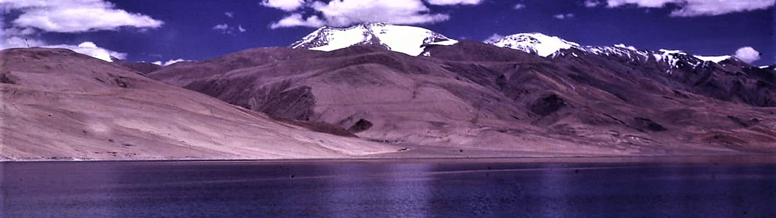
At the south-east end of Ladakh, between the rivers Indus and Zanskar lies Rupshu, perhaps the most barren, windy and the coldest part of Ladakh, with temperatures dipping to -40°C. A road connects Leh to Karzok, at 4,527 m the only inhabited village in Rupshu, overlooking the beautiful lake of Tso Moriri. The monastery at Karzok, south-east of Leh, is almost 500 years old. Karzok is inhabited in winter by the Changpas, nomadic shepherds who graze yaks and sheep. They live in yak-hair tents of peculiar form, made out of two pieces of cloth held together by ropes made of yak tails, with a six-inch opening all along the top that allows smoke to pass through, and is narrow enough to prevent rain and snow from coming in. The space within the tent is optimised by a hair-cloth, stretched by ropes over forked sticks and then packed down. Little multi-coloured flags and yak tails fastened to bells ornament the tent from the outside, which is guarded by ferocious shepherd dogs. Against the backdrop of the high peaks and the bleak landscape, with only the lakes for relief, a colony of these tents stands out defiantly.
Rupshu is known for its lakes. In the centre is the Tso Moriri, a vast brackish expanse of about 125 square kilometres that takes on the myriad hues of the sky. The Changpas narrate a tale about a young nun who lost control of the yak she was riding, and was pulled into the lake (‘tso’) despite her desperate cries of ‘ri, ri’ to stop the yak. Hence the lake is named Tso Moriri. Rising above it are the peaks of Chhamser Kangri (6,622 m) and Lungser Kangri, which at 6,666 m is the highest peak in southern Ladakh. These summits were climbed for the first time as recently as 1995 by an Indian team and have since become a popular objective for many climbers. Further east of Rupshu, where Indus enters the Indian territory at Demchhok from Tibet, stands the ancient monastery of Hanle, founded by the Ladakhi ruler, Sengge Namgyal in the 17th century. South-west of Hanle, is Parilungbi (6,166m ) and Parang la that connects Ladakh to Spiti. A glacier of about three kilometres to the north-east of this pass has a number of crevasses, making it difficult to cross into Ladakh. The Parilungbi that guards this pass, is the first peak in Ladakh to be seen from Spiti, and served as a prominent landmark for Tibetan traders as they crossed the Indo-Tibetan border at Parang La. As per gazetteer a tax collection post was settled near this pass (and at nearby Takling La) for salt was taxed and trade with Tibet was regulated. A brave officer must have stayed in this inhospitable surroundings.
In the northern areas of Rupshu is Tso Kar, a salt lake in a vast plain with deposits all around. Much of the water in the Tso Kar has dried, the marks at various levels above the present lake indicating the larger swell of its waters. Once its salt was used by the entire district and even for trading. To the north-east of Tso Kar, at a height of 4,300 m, is Pangong, an unusually long and narrow lake, stretching for 135 km and about 3 to 5 km wide. Overlooking the lake to the south is the Pangong range that holds the peaks of Kakstet (6,461 m) and Kangju Kangri (6,725 m), scaled by Indian Army teams in 2001.
These lakes are homes of much wildlife. Snow leopards have been photographed on the shores of Tso Moriri, famed black-necked cranes are seen, Himalayan eagles and Lammergeyer fly in the area, the famed pashmina producing goats and Chirus are in the adjoining valleys of Tibet and Aksai Chin. It is quite common to observe some of these wildlife (except elusive Snow Leopard) while travelling with marmots peeping their heads from their tunnels on ground.
Zanskar
The Zanskar district, largely occupied by ridges, ravines and snowy watersheds, is to the south-west of Leh, bounded by the Zanskar river to the west. Draining the region, the river flows northwards to merge with the Indus near Nimu, a few kilometres west of Leh. Situated amidst a maze of mountains, the approach to Zanskar is difficult from all sides. To the west and south is the main Himalayan range, which lead to Kishtwar over the high passes of Hagshu, , Umasi, Muni and Poat Las. Towards south is Shingo La, a popular pass with trekkers, leading to Lahaul. In west Zanskar is Padum, and the road running north-west, the only road in Zanskar at present, leads to Kargil. New roads which will lonk Padum with Leh along the Zanskar river and with Darcha, across the Shingo La are under construction. Zanskar receives heavier snowfall than upper Ladakh, and its climate is severe with winter lasting for almost eight months.
Like a true Buddhist country, Zanskar contains some beautiful monasteries such as Sani, Karsha, Zumkul and Puktal. Constructed in a massive cave about 100 m above the Tsarap Lingti river, the Puktal is perhaps the most dramatic gompa as it spills out in a cascade of whitewashed cells that adorn the entire mountainside. According to a legend, this site was chosen because of its forested slopes, a rarity in this barren landscape. Today, the only trace left of the forest is a lone tree, which is said to house the spirit of the first Buddhist guru in Zanskar. It is believed that almost 500 years ago, a saintly lama passed by this cave and urged the three ascetics, who had taken shelter here, to build a great monastery. When the ascetics expressed their doubts, as the cave was too small, the lama performed a miracle and made it grow to its present gigantic size. Phuktal lies on the popular trekking route that begins from Shingo La, courses along the Zanskar river, over a few passes, to Lamayuru monastery at the extreme west of Zanskar.
The pride of Zanskar is the Nun Kun massif to the west, which stands on the great Himalayan axis that runs from Kamet to Nun-Kun, stretching beyond to the Deosai plains running north-north-west, The three major peaks in this group are Nun (7135 m), Kun (7087 m) and Pinnacle (6952 m). A high snow plateau between Nun and Kun narrows to an icefall, forming the eastern branch of the Parkachik glacier. The Fariabad river originates to the glacier’s south, flowing into Kishtwar.
The first close examination of this group was made by Dr Arthur Neve and Reverend C E Barton, a missionary working in Kashmir, in 1902, followed by the American explorers, Dr Hunter Workman and his wife, Mrs Bullock Workman in 1904. Kun was climbed by an Italian Count Calciati in 1913, but the neighbouring peak of Nun remained unconquered till 1953, when it was scaled by a French party led by Bernard Pierre. This expedition travelled through unfrequented valleys, and climbed this high, remote peak from Kishtwar and Fariabad valley. The French team was divided into two and they attempted the peak in succession. While Bernard Pierre and Pemba Norbu gave up due to too much snow, Madame Claude Kogan with Pierre Vittoz reached the summit. For many years Nun and Kun were left alone, as Ladakh was closed to foreigners from 1962. In 1974, when Ladakh opened its doors to all mountaineers, these two peaks were climbed with steady regularity. However, in 1999, the parts of these areas were closed again due to the deteriorating security conditions and the Kargil War thus preventing mountaineers from further exploring the summits.
Nubra Valley
Strictly speaking the Nubra valley is part of East Karakoram, a range across Khardung La pass and range. However now it is easily accessible to tourists and trekkers by road and it is regularly visited from Leh. Once it was a forbidden territory and difficult to reach, the Nubra valley with several picturesque villages such as Sumur, Tegar and Panamik, was opened to tourists only in 1994.
Panamik is famous for its hot springs, while Sumur houses the beautiful Samtaling Gompa founded in the early 18th century by lama Samtan. The Nubra river drains the Siachen, one of the longest glaciers in the Himalayan range, and merges with the Shyok near Khalsar, with the monastery of Diskit perched on a hill nearby. A little to the west lies the tiny village of Hundar with a monastery near the road from Khalsar to Partapur-Chalunka. Areas further west are restricted at present.
In the watershed between the Nubra and Shyok rivers, south of the Saser la, is the Saser Kangri group, which has five major summits, the highest being the Saser Kangri I at 7,672 m. Photographed by Dr Arthur Neve, the explorer of the Kashmir area, in 1899, it received further attention from the British explorer, Dr Tom Longstaff, who observed it in 1909, and from the great Karakoram explorer, Dr Ph C Visser, who briefly explored it in 1935. In 1946, British climbers, J O M Roberts and G Lorimer undertook a detailed reconnaissance of the entire Saser Kangri group, along with two Sherpas. Although they could not make a serious attempt on the Saser Kangri I, they observed it from the Phukpoche glacier to the west, concluding that none of the approaches appeared climbable from here, and the assault from the east was more likely to succeed.
The Saser Kangri I was ultimately scaled in 1973 by an Indo-Tibet Border Police (ITBP) team that approached the mountain from the east. Going on the winter trade route along the Shyok river, they turned into the glacier to climb the peak. By the time the summiteers returned, it was August, and the Shyok river was flooded, cutting off their retreat. Winding its way in the valley, the waters now swelled up to touch the steep cliffs on its sides, making it extremely difficult for the party to negotiate the route. They faced the gruelling prospect of going up the river, sometimes crossing it almost thirty times a day, to return across Saser la. They managed to do this and survive, a feat perhaps more difficult than ascending the summit.
The earlier name of the valley was ‘Yerma’ after a small gompa on its right bank across from Sasoma. In this monastery exists text written in golden ink. It is believed that deposits of gold exist in rocks behind the gompa and it shines in the evening in setting sun. The early visitors, after waiting for the rocks to turn golden, made laconic comment that, ‘it for faithfuls only’. However the valley was a refuge of travellers from Central Asia who had to pass from the valley en route to Karakoram pass or towards Leh. The villagers supplied fuel, fodder, food and mules for the journey, making them prosperous. Some of these Muslim traders stayed in the valley for winter when passes were closed and married into Buddhist families. Their off-springs were called ‘Argans’ and a large grazing ground, ‘the Arganglas valley’ was given to them to survive. However with blood of traders in their veins the Argans rose to be rich, powerful and occupied high ranks.
In the last thirty years, Ladakh has become an increasingly important tourist destination, which has had a bearing on the lives of its people, raising their consciousness about the world outside, and creating new opportunities for them in terms of employment. Development projects by way of schools and improved roads cutting through mountainsides have lessened the hardships faced by the people to a degree, but have also brought in more tourists. The inevitable fallout has been a tremendous pressure on the region’s fragile ecology and an increasing threat to the already endangered wildlife. The harsh climate and terrain no longer being a deterrent to visitors craving for adventure and novelty, the problems faced by Ladakh today can only be countered by an increased awareness and a more prudent approach towards tourism.