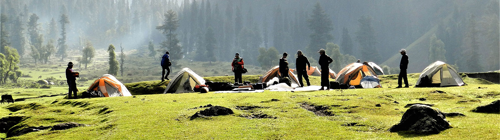
Camp in lower valley
Share on Social
THE BAGPIPE TREKS
Small Treks in Lower hills of Kumaun and Himachal
An advertisement for a good whiskey shows two friends, sitting by a fireplace, sipping whiskey. “At one point, after few sips and you will hear 100 bagpipes playing in the Hills”, one of them says. And so, after a few sips the other friend extend his glass with a mischief a smile, “Can I hear some more bagpipes?” Same is the case with light Himalayan treks with good friends. You want to have it more and more. iumalayan treks with closH
Many times I had to visit Delhi for a short visit from Mumbai. Dealing with babus and the bureaucracy in the capital city could be quite exhausting. So to relax, I would meet my friend, philosopher and guide, the famous writer, Bill Aitken . As we had lunch, watching cricket and talking mountains, he would suggest several ideas enough to fill in a year of trekking. Bill specialises and believes in ‘A Lateral Approach to the Himalaya’[1] and would firmly suggest ‘more of the lesser’. I would tuck the information away in my mind and when an opportunity arose, I would go on these small treks from Delhi. Some were 10 days and some were only 4 days (return). We called them ‘The Bagpipe Treks’.
Chiltha Ridge
One such trip was along the well-trodden path to the Pindari glacier. We travelled from Delhi by an overnight train to Kathgodam, drove to Almora and reached Loharkhet, the starting point of this popular route. Our friends Harsingh and others from the nearby Harkot village were waiting for us with all arrangements. We crossed Dhakuri pass the next day enjoying wonderful views. Staying in rest houses, we enjoyed the forest via Khati and Dwali. The Pindari trail may be overcrowded or too popular but it is still beautiful. We retraced our steps back to Khati and climbed up a ridge to the east of village and were soon on the Chiltha Devi dhar (ridge). We spent the first night at Brijaling dhar and were rewarded with exquisite views of Pindari glacier and Nanda Kot peak. At a leisurely pace we made our way to Chiltha devi main temple in the west situated on the highest point of this ridge. This is one walk I would never forget for the rhododendron flowers. They were in full bloom and in several colours, all this with the backdrop of Nanda Devi and Nanda Kot made for a wonderful setting. The Chiltha devi temple itself was an isolated place and looking on both sides of the valley. Towards north were the peaks in the Nanda Devi Sanctuary leading towards the Pindari and in the east and to the south were the blue Shiwalik hills. There is a small dharamshala, (a local rest house for pilgrims) with running water. Few hours on this plateau was enough to rejuvenate us. Next morning, starting early we descended to Dhakuri pass and made our way back to Loharkhet for a taxi to catch our trains to Delhi. By next afternoon, we were in Mumbai savouring those four days of trekking.
Madhari Pass
Extending the idea of such a fast trek, I returned to my favourite corner of the Himalayan again, now with a group of friends who lived in Chicago. Their desire to see this mighty range and response to Himalayan views made for good company.
This is an all-weather, low-altitude trek which offers an excellent walk in remote, unknown valleys. Large grazing grounds, called kharaks, are a joy to camp on. The greenery and the forest at many places will take your breath away. From the passes some snow views of the Nanda Devi peaks are seen. From the upper Ramganga valley, a large number of snow peaks on the Pankhwa Dhar are seen, with rugged rock gorges. If you proceed further east across the Rur Khan pass, the view of the Panch Chuli range is unforgettable.
It is best to travel from Delhi by the night train, arriving at the railhead at Kathgodam, early in the morning. Taxis took us to Bageshwar and Loharkhet.
On the first day we started early as the weather in the valley can be warm in the summer months. At first, the trail proceeds to Munar on a partially constructed road . The trail then climbed steeply to Supi (1810 m). Supi is a lovely little village situated on two levels. Energetic trekkers may go up to the upper village where a small temple is situated. However the usual trail traverses from the lower village across the slopes till it descends to meet the Saryu river again at Bhadratunga (1600 m). There is a temple dedicated to the goddess Bhadratunga here and with thick forests around it, was an ideal camping ground.
Ahead, we crossed a bridge over the Saryu river to the left bank. The trail now climbed steeply on a broad village trail. This was the Khalpata valley leading to a village of the same name. There were several ups and downs and the trail was generally amidst thick forest. Above Khalpata village was the Nigaliya Kharak (2240 m) an ideal camping site with a lovely stream flowing nearby. This was surrounded by a forest and was the first of the several open kharaks (grazing grounds as they are called here).
The trail continued to climb 800 m to reach Madhari pass(3040 m) in 4 kms. This pass is on the watershed between the Saryu and the Ramganga. It is a long and forested ridge and can be crossed at several points. The final approach is through a wide-open ground from where on a clear day the peaks of Nanda Devi can be observed.
Somewhere in middle of this trek near Madhari pass, a smart looking elderly gentleman sat down to join us for water and snacks. I could see a few tall stick-like objects jutting out from his rucksack. I asked him what were they and before he could reply, our Harsingh in his usual style said that he was a musician and played music at weddings and other celebrations. When I asked him to show the instrument it turned out to be a proper Scottish Bagpipe. The gentleman had retired from the Indian Army Kumaon Regiment and was trained to play the bagpipes. After retirement he began to play famous tunes at wedding and other festivals. I asked him to play for us. Suddenly the forest magically came alive. It was so uplifting an experience that we asked him to walk down with us as he was going the same way. All through the descent he kept playing tunes on the bagpipe making the mountain valleys e vibrate with its high-pitched sound. No wonder bagpipes are called highland pipes for they serenade the mountain gods.
A steep descent leads into the Ramganga valley in the east. We passed several beautiful wide open kharaks one after the other, with the trail loosing height rapidly. Raj Kharak was a wide and beautiful grazing ground to camp on. But unfortunately there was scarcity of water and we had to descend further to lower Raj Kharak (2520 m).
We continued the steep descent into the Ramganga valley passing Parthi village and Kautibula. From the bridge over Ramganga a broad trail leads to the school in Namik village 4 km away. This was a fairly large and prosperous village, full of activity. We camped at Bhagwati temple (2270 m) above the village.
Namik was a meeting place of other trails too. A walk down the valley would lead to Gogina and Leti where transport was available to reach either Bageshwar or Tejam. A visit can be made to the Namik glacier, which is at the head of the valley.
Sur Sungri Pass
A broad trail continued to climb from Namik village towards the Sur Sungri pass. It passed through some interesting forest to reach a camp-site at Upper Ghel Gadi (2900 m). Next day, the climb to the pass, 3 km away, took about 2 hours. This pass is named Sur Sungri (3240 m) after a local legend.
In the local Kumauni language, a tiger is called Sur and a boar is known as Sungri. As per legend, a boar once accosted a tiger on this pass. As the boar did not yield the tiger was rather angry. To vent his anger he dug a large hole near the pass, (which is prominently seen near the pass today). After a long chase, the tiger leaped from nearby slopes for the final kill. But he fell in his own pit and died. A kind of local David and Goliath story, is the Sur-Sungri legend.
From the pass, looking westwards across the Saryu valley, the entire panorama of Pankhwa dhar and the snowy peaks of the Nanda Devi Sanctuary were seen. The ridge to the north leads up and above to Sudam Khan. It is quite challenging, but offers great views of the Nanda Kot range.
There were two routes ahead from the Sur Sungri pass. One was to go east to cross Rur Khan pass, difficult if snow bound. So we turned south on the main trail down the Jakala valley. Through a forest and across several side nalas the trail emerged on kharaks, which were used by shepherds of Birthi village. Camping on the Ruger Kharak (2240 m) was a welcome relief after a tiring descent.
Starting leisurely the next day, we descended steeply again to the main road and walked up to Birthi village (1800 m). This was a small village with meagre facilities. We reached Munsiary in the northerly direction across Kalamuni pass (2748 m) with views of the Panch Chuli group. The final view of Panch Chuli was worth every effort.
Panch Chuli Group of Peaks
The most visible symbol in the valleys of Kumaun are the peaks of Panch Chuli. As per the legend, these peaks are named after the five Pandava brothers from the Indian epic Mahabharata. The peaks represent their cooking hearths (chulis) as they cooked their last meal before proceeding to their heavenly abode. As one watches the group from the bungalow at Munsiary at sunrise, the rays directly reflect on these tops and throw the light upwards to the sky. The same scene is repeated in the evening, a little after sunset, for the people in the Darma valley to the east. Thus the legend is firmly established in folklore.
The Panch Chuli peaks lie in the Eastern Kumaun and are seen to great advantage from the Kalamuni Pass and Munsiary. They form the watershed between the Gori and the Darma Ganga valleys. The eastern approaches are through Sona and Meola glaciers. The Uttari and Dakshini Balati glaciers guard the western approaches. The peaks are numbered NW to SE—I (6355 m), II (6904 m), III (6312 m), IV (6334 m) and V (6437 m).
Churdhar
Bill Aitken in an article mentions that the British called the peak in the foothills of the Shimla hills as ‘ the Choor’. The Choor according to Lt. White ‘is the most lofty eminence belonging to the secondary Himalaya, running south of the great snowy range from whatever point it may be seen forms a grand and prominent object, towering majestically amidst host of satellites’.[2]
I was to see this grand peak in tragic circumstances. Our family friend Major Navneet Vats was killed in action in Kashmir. He belonged to Chandigarh. To offer condolences I flew from Delhi to Chandigarh. Looking out of the window I could see the Chur, a prominent hill, and the first peak of prominence rising above the plains of Punjab. I tucked away this view and Bill’s writing somewhere in corner of my mind.
So one early November, keeping in mind five days of free time at Delhi, we planned a quick trip to Churdhar, one of the well-known points with historical significance and easily approachable.
A taxi from Kalka carried us to Rajgadh, which in the early autumn light looked serene and beautiful. Soon we were alighting at a small PWD rest house of Nohra (2160 m). That evening to acclimatise we took a small walk to the temple of Kudon devta. A small boy accompanied us as guide. He was talkative and made good company. As we reached the temple he stopped at the steps below and would not come up with us. When I motioned to him, ‘Why don’t you come up’, he smiled and remained away from the parapet. He said villagers would thrash him if he came up for he belonged to a lower caste. Even when we told him that these are things of past he nodded his head, ‘Not in this part of the world’. Even this next generation was not ready to break the traditional rules or were too scared to do so.
Early next morning we climbed up steeply to the ridge behind the bungalow and then proceeded along this gently and lightly wooded ridge to camp that night at Tisri (3180 m). From here we one could see much of the Kullu Himalaya, starting from lower peaks to Deo Tibba and Indrasan. There was light snow around and we sheltered comfortably in a shepherd’s hut.
The climb to Churdhar (3647 m) was steep and was more tiring because of snow. We made our way to the top easily to a stupendous 360° view. A statue of Shiva adds those required 5 feet on the peak to make it reach 12,000 feet. We could see the hills of Shimla and completing the view were the peaks towards south. As the legend has it, Churdhar was the nearest point from Delhi where snow could be found even till early summer. The Moghul Badshahs (kings) used to organise horsemen who would pick up snow from Churdhar and ride in rotation to the Red Fort in Delhi so that the Badshah could have a chilled drink in the evening. Whatever may be the truth, the snows of Churdhar were certainly enchanting.
We descended to our camp, packed up and were down to Nohra on the same day, tired but very happy. A jeep ride and a train to Delhi again took us to fly to Mumbai. Perhaps the spirit of my friend Major Vats lives there and had called me to pay obeisance.
Budha Pinath
For a trip to this mountain, Bill Aitken, the master himself, accompanied us. It turned out to be a group of nearly fourteen people of variety of interests and strength. We all gathered at Suman Dubey’s lovely bungalow at Kausani (1600 m), enjoying flowers in his garden and the view of the Himalaya. Our trek began right in the earnest next morning and crossing a ridge we were at Khatni. Then began the gruelling climb towards the lower Pinath temple (2400 m). It was quite tiring due to hot sun even in late winter. Lack of water made it more exhausting. We reached the temple with surrounding small houses, but to our dismay we discovered that there was not a drop to drink.
There were only two alternatives, either to go down or ask our faithful Kumauni young boys to bring water up to this plateau. I wonder how many times during all my treks these sturdy companions have saved the day. We took the second option and very soon a restricted supply of water was available to us. That evening was enjoyable, listening to stories by Bill and restless prowl of Suman Dubey wanting to get off to the summit. We did that next early morning as Suman ran like a hare for he wanted to reach the top and back to his lovely bungalow the same evening. Zigzagging through sparse forest, we followed Suman who disappeared from view and we were completely unaware of his reaching the top and going back causing minor anxiety. Maninder, who went down too was asked to wave a flag if Suman was at the lower temple and well. It was more confusing as tired Maninder waved the flag too briefly for us to see. That caused an animated debate whether to mount another rescue! Luckily we did not as I had confidence that Suman would be sipping beer by evening in his garden. He did just that.
On the top of Pinath (2760 m) was a small temple, which had some beds and evidently some Swami used to stay here. It had not been used for sometime evidently. We pitched tents few meters down and brought up water, again from a little distance. Some of us decided to settle in the temple and spread out our sleeping bags watching the magnificent sunset for nothing obstructed the view from this high conical peak. As we were about to sleep, the owner of this kutia arrived, having done more than 30 km of trekking across the valleys. He looked exhausted and very politely claimed his place. After a long chat, offering him tea and some food we moved down to our camp and spent a crowded night.
The return was towards the west as we descended to Nyuli (1370 m) and camped little before Tarag tal. This was a beautiful valley, but again lack of water all along was a worrying factor. Tarag tal was a seasonal lake and every monsoon the lake would fill up, and later this fertile ground was used to plant crops. We walked through rice fields and as we reached the other side, we met a road with taxis leading us to Ganai Chaukhutia (900 m). As we ended our trek at Ganai-Chaukhutia, in a busy bazaar, Bill suddenly called me aside. He pointed to a marble plaque near a bridge. It read, ‘Pattis of Chaukot and Gewar. From this village 134 men went to the Great War of 1914-1919. Of these 112 gave up their lives’. A post box hung near it and in between the hustle and bustle of bazaar, Bill had noticed this historical item. No wonder his keen observations have been reflected in his writings which inspire many like me.
Sometimes friends and the people you work with, frown upon such short quick holidays for it disturbs their rhythm, just as it builds up my rhythm to face the rigours of life. Why do you do this, they ask, like the famous question to Mallory, why climb. My reply is simple, ‘Blame it on Bill’.
[1] See his article of same title in the Himalayan Journal, Volume 57, p.1
[2] Touching Upon Himalaya, by Bill Aitken, p. 19.