Bandarpunch from Nag Tibba
Share on Social
THE FREEDOM WALK
A Trek in the Lake District of Garhwal
(1997)
As India celebrated the 50th year of Independence, on 15 August 1997, we discovered that there were several extra holidays to celebrate the event. Many politicians were descending to Bombay, many events were planned and all the brouhaha would lead for certain to traffic jams and noise. So what could be a better way than to spend a week in the mountains, after all mountaineering is about ‘Freedom of the Hills’, is it not?
‘Uttarkashi is wet, wetter than you can imagine’. We ran into two Principals of the Nehru Institute of Mountaineering (NIM) in Delhi, and that’s what they said.
Armed with this ominous information, on 12 August five of us reached the NIM in Uttarkashi. Its sprawling campus amidst pines was a perfect starting point for us. Till we, the five-member team, reached Uttarkashi it was raining heavily, and had poured for the previous week confirming the warning we had received. In fact we bought umbrellas and plastics for all. Shekhar was carrying a fancy ‘double’ umbrella and to tease his wife Sheela, that piece of fancy gadgetry was nicknamed ‘the second wife’. But behold, all through our trek except for a sharp shower or a wet afternoon, the weather gods did not trouble us. Well, one does not mind an unpredictable weather if it’s in ones favour!
With all the arrangements made we travelled to Malla (1500 m; 24 km by road) to begin the trek. After crossing the Bhagirathi river the track climbed steeply to Sila (2040 m; 6 km). We were housed there in the village school. There were some preparations on for the 15 August celebrations, children were singing patriotic songs in preparation of a prabhat pheri (morning walk) on that historic day. But we were worried about our own walk ahead. The track relentlessly climbed steeply, in fact too steeply for us to enjoy the beautiful forest we were in. Many Gaddis (shepherds) climbed up along with us for we were heading towards the most fertile bugiyals (meadows) in the area.
Kush Kalyan, our goal for the day, was almost 1600 m above us and each of our co-trekkers, even the Gaddis, found it tiring. We went across Chuli la (3580 m), a small pass on the ridge and the climb ended. By late evening we camped little before Kush Kalyan. Amongst us, Arnav found the going exhausting, possibly it had something to do with eating too many steaks and burgers in the USA!
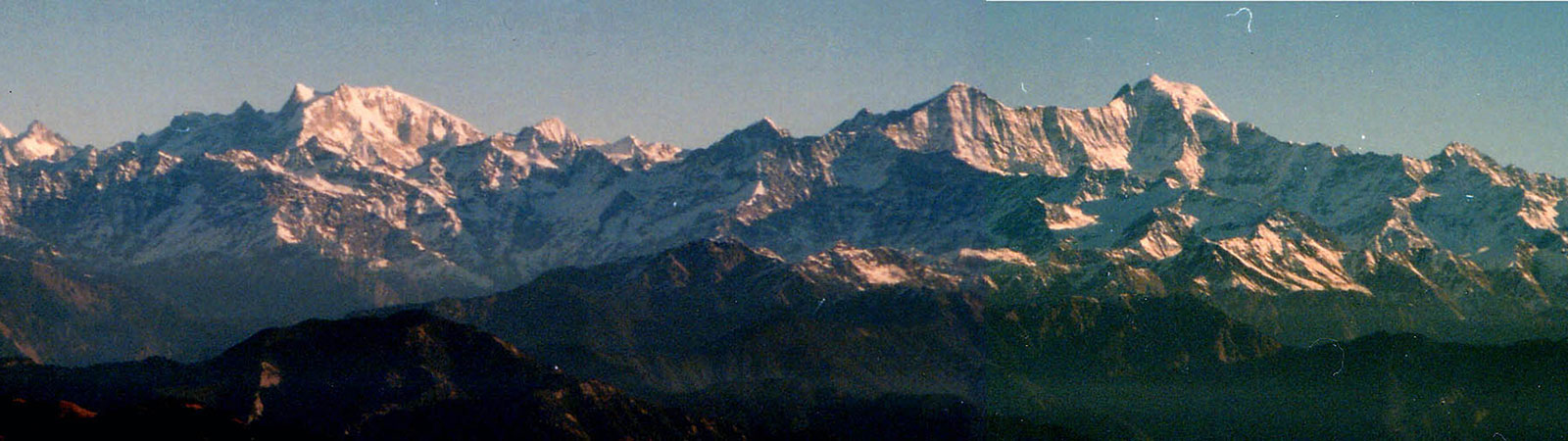
That evening we were treated to a most beautiful panorama of the Bandarpunch massif. My thoughts were with J.T.M. Gibson, who in the fifties had attempted each of these peaks and climbed several of them. He introduced young Indian mountaineers to the sport of mountaineering in these ranges. On our right was Kalanag (6387 m), the highest of the peaks before us. It rose like a ‘black serpent’, as its name implied. In the centre rose Bandarpunch (6316 m), the ‘monkey’s tail’. Both these peaks were tried several times by Gibson with different parties from the Doon School, where he was the Head Master. Bandarpunch was climbed by his team. R. Greenwood, Tensing Norgay (‘before Everest’) and Sherpa Tsering reached the summit, in 1950. Kalanag defied two attempts by Gibson, in 1953 and 1955, and it was finally climbed by another party from the Doon School in 1968. Today it is perhaps the best known (and most climbed) peak in the Garhwal. The peak that beat Gibson and Tensing Norgay narrowly was Bandar-punch West (6102 m) to our left. They had followed the sharp southern ridge but had to stop. In 1984 the first ascent of Bandarpuch West was made by me with a team from Bombay. We had followed the northern route. Having climbed Kalanag we were well acclimatised and were able to go through the highly crevassed Bandarpunch glacier. The final slopes had been fun to climb. Today many, like us, have enjoyed climbing in the Bandarpunch range but it must be remembered that it was here that the real freedom to roam the hills began for generations of Indian mountaineers.
Our trek continued on 15 August, the momentous day. On the radio patriotic songs and speeches were broadcast without respite. It reminded me, in a different vein, of an Italian movie.1 When the Abyssinian War (1935) ended, every station was broadcasting commentaries of the great victory marches and speeches, whilst the frames showed farmers working in the fields as usual, unmindful of the great day. Our situation was somewhat similar.
We were in the company of some elderly shepherds, many of whom were born before the Indian Independence. None of them remembered the effect the historical event had on their lives. They lived in the hills and the area was in the erstwhile Tehri State. As there were no roads, they were almost 10 days away from the nearest civilisation. Without a radio or any means of communication, they just ‘heard’ from the pilgrims that India was free. It made no difference to their lives. And frankly even today they had not much knowledge of the drama enacted in the plains, in the celebration of this day. They walked, as always, with their flock, smoking a bidi and listening to the radio with amusement.
That afternoon it poured heavily as we crossed Bhowani bugiyal and later went across Kyarki Khal (4077 m). By late evening we camped at Kyarki (3900 m; 12 km). Our neighbours were a family of Gujjars. They migrated to this ground every year, for about five months, they said. Amongst them was a young couple, married only for a few months. Life was simple and happy for them. The husband charmingly put a shawl on the young wife when she felt cold, and she knitted special caps for him. They had horses which roamed about in gay abandon and a dog that barked all the time. It was peaceful and in the setting sun everything appeared romantic. Even after three decades in the Himalaya, and five decades in this world, for me still there were things to enjoy and learn!
The views were incredibly lovely as we climbed further on to a ridge. A ridge full of flowers had the Bandarpunch massif in the background, while the Jaonli peak was seen rising in the north. It was a magnificent setting: the lush green bugiyals with several goats and sheep grazing around. Once on the Kukhli Dhar we reached a well-made footpath.2 This path was constructed from Buddha Kedar, from the Tehri district in the south. It was built several years ago for the pilgrims to visit Shashtru Tal. Similarly a small dharamshala was built on the ridge, which is now in ruins. We camped little ahead of it, overlooking Lamb Tal (4300 m; 6 km).
Next morning was brilliant. We hoisted the tricolour of India overlooking Lamb Tal in a sentimental display of the Independence Day. Mehernos and I left early and scrambled up a small peak, ‘Lamb Peak’, 4550 m. The view of Shashtru Tal was magnificent.3 Going to the shores of Shashtru Tal would have taken about two hours. Being situated in a bowl it would not offer any view. Shashtru Peak (5154 m) rose behind the lake like a sentinel. Dodhi Tal was in the front. Several lakes were seen en route and were marked on the map on both sides of the ridge, amply justifying the title ‘Lake District of Garhwal’ awarded to this area by the prolific writer Bill Aitken.4
That evening we camped once more near the same Gujjar couple, now joined by their old father. I could not resist asking these nomads what they thought of the Indian independence and that historic day exactly fifty years ago.
‘I came to Kush Kalyan then’, the old man replied. ‘That time we used to travel on foot from Saharanpur, and even today we do the same. We have our flock with us.’
‘What about the future?’, I asked.
The young Gaddi interjected, ‘As long as I am alive I will be here and the yearly migration will continue in the same style’.
‘What is the effect of the fifty years of Independence, what about freedom?’
He thought for a while and replied with a smile, as if it was a state of mind.
‘We were always free’.
Notes & References
- ‘Christ Stopped at Eboli’, Italian film by Francesco Rosi. It was based on the book of the same name (1946) by Carlo Levi, painter, doctor and writer banished to a small primitive village of Lucania in southern Italy at the start of the Abyssinian War. He stayed there throughout the war, observing that historical events had no effect on the simple life of simple villagers.
- This is locally called chhe phuti path (the six-foot-wide path). It follows the route from Tehri to Buddha Kedar by road, and then to villages Jhala and Pinswar to reach Shashtru Tal. It links Masar Tal, the lake above Pinswar village. It has beautiful views and a gentle gradient.
- The name ‘Shashtru’ seems to have originated from the Sanskrit word ‘Sahastra’ which means ‘a thousand’. It refers to a thousand brahma kamal available in the area. These were the most beautiful flowers to be seen at this altitude and there were at least hundreds of them, if not thousands.
- See article by Bill Aitken, ‘Monsoon Madness and Seven Lakes’, in the Himalayan Journal, Vol. 42, p. 168. Bill is the practitioner of true freedom of the hills!