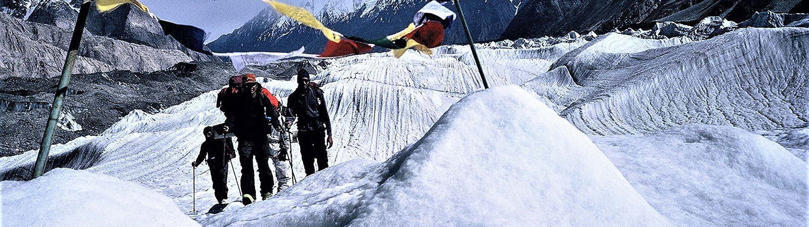
Crossing a Glacier
Share on Social
THE HIGH ALTITUDE GOLF COURSES
On the Karakoram Pass Trail
2000
In the trans-Indus regions of Kashmir, sterile, rugged, cold and crowned with gigantic ice-clad peaks, there is a slippery track reaching northwards into the depression of Chinese Turkestan which for all time has been a recognised route connecting India with High Asia. It is called the Karakoram route. Mile upon mile a white thread of road stretches across the stone-strewn plains, bordered by the bones of innumerable victims to long fatigue of a burdensome and ill-fed existence – the ghastly debris of former caravans. It is perhaps the ugliest track to call a trade route in the whole wide world. Not a tree, not a shrub, exists, not even the cold, dead beauty which a snow-sheet imparts to highland scenery.
( T. H. Holdich. Gates of India)
Not everyone likes the Karakoram. The barren and the rugged trail, leading on for miles and miles is not attractive to everyone. Due to security requirements there are several camps of the Indian army along the trail and these simple soldiers just fail to understand why anyone like us from Bombay or any part of the world would like to go there. As one officer put it, ‘What do you see in these Ganje Pahad (bald mountains)? This barren land ?’. But if you are bitten by the bug of barrenness, the history of the area and the ruggedness of the terrain, you would go, and return. As I returned to the Eastern Karakoram areas again in July 2000. Ours was an Indian-French joint expedition during which many areas were explored and two peaks were climbed.
On the Skeleton Trail
With everything loaded onto the mules, on 1 August we started trekking from Jhingmoche, 18 km ahead of Sasoma, which was originally the beginning of the trail (Sasoma in the Nubra valley is connected by road with Leh, headquarters of Ladakh). Now a rough narrow road drives up the Tulum Puti la to Jhingmoche. No sooner had we covered a couple of kilometres, than the flooded Thangman nala stopped us. It took almost 8 hours to cross this, after fixing ropes and erecting a small stone bridge. We camped immediately, across the nala. Flooded nalas and fast flowing rivers were going to be our constant source of worry on this long trail.The next 2 days were rather routine as we gently and sometimes steeply climbed towards Saser la, the dreaded pass which I was crossing for the fifth time. Snow appeared far less this year as our mule caravan slowly crossed it. We were now on the famous Karakoram trail, or the ‘Skeleton trail’ as it is sometimes called. On passes like these many caravans were trapped and the route was littered with bones of mules and sometimes of humans also.
As we climbed up to the wind swept Saser la, we had gained a good deal of height, for Saser la is 5395 m and without proper acclimatization anyone would find it very difficult to cross this. The trail, in fact, has received many ‘compliments’ on its arduous nature.
A Chinese writer in about the year 25 B.C., gives a graphic account of the difficulties and hazards to be met within a journey from China to Kashmir, “ ….you would have to cross over great mountains, called the Headache Mountains, as they cause headaches, fever and vomiting. Then follows a path through the gorges thirty miles long and two feet wide. A single slip means being hurled into a bottomless chasm.” There is nothing to prove that this refers to the Karakoram route. But the mountain ranges do not offer many alternatives. It is probable that the writer was describing the trade route that is used today. Certainly about A.D. 950 there was trade being carried on between India, Yarkand and Kashgar by way of Ladakh.
(The Antique Land. By Diana Shipton, p. 14)
On the eastern side after a steep descent and a camp we went past Saser Brangsa to the crossing of the Shyok river on a garari. That famous crossing via a single iron wire was an experience that no one will forget in a hurry. Making it a long day we continued onwards to camp at the Chhongtash. The Chhongtash gorge was another formidable landmark as the trail crossed the fast flowing nala. I counted at least 53 crossings of the Chhongtash nala in just 5 km, with steep walls rising on both sides. An army soldier walking with us remarked, ‘Who needs guns, an invading army in this gorge can be stopped by throwing pebbles from the top. No one can escape.’ After the gorge we camped, very tired, in a vast plain with one large rock (Chhong Tash, chhong- huge, tash-rock) [1]. The next day we did a short march, went past Murgo and camped at Kalon Chumik. It was pleasant and Kalon Chumik had pleasures of its own, but the impending danger of entering Murgo, the ‘Gate to hell’, loomed ahead. As we entered the Murgo gorge and proceeded along the Burtsa nala, the worst of the Karakoram trail was evident. For many kilometres there was no drinking water and we had to trek 26 km in a single day. We took almost 11 hours to cross this gorge. The trail at one point climbed more than 1200 m and again descended the same height. Slopes after slopes of Burtsa shrubs, after which this camping ground is named, were seen.
Due to the long distances to be covered, it was late in the evening that we were criss-crossing the nala. It was dangerous and tiring to cross it, as it was now in floods and with no end in sight. All one could do was to put one’s head down and keep marching and remember what Eric Shipton had said about the trail:
For next 10 days we travelled through a labyrinth of gorges and across high, barren ridges; utterly sterile, completely devoid of plant and animal life, it was the most forbidding country I had ever seen.
Nothing is known of men who, centuries ago, first ventured across this monstrous wilderness in search of trade or conquest. It is easier to imagine the toil, hardship and frustration they must have endured than to understand what inspired the courage and tenacity needed to discover a way.
(That Untravelled World, by Eric Shipton. p.144)
As we reached the camp at Burtsa, I certainly had the distinct feeling that this was not a trail for trekkers, the caravans always had sahibs riding on horses, and that’s the way to travel here.
We continued now along the Depsang nala, the Burtsa nala having turned sharply towards the east leading to the Aksai Chin plateau. The same story continued. The flooding of the nala, the criss-crosing trail and the vast plains. Mercifully, we had to decided to stay at Kazi Langar, 14 km away, which was reached by mid-afternoon. Many early explorers had written about the ‘romance’ of this trail..
This trail had been used for generations by officials en route to Yarkand, traders and by pilgrims. It was the route used by the Muslims of Central Asia to visit Mecca, the holiest shrine of the Muslim faith. What a journey they undertook !Perhaps that’s what gave rise to the saying ‘Faith can move mountains’. It certainly helped to go across them. Central Asian Muslims would start from Yarkand, cross Shahidulla, and come across KKP into Ladakh. Going along the Burtsa stream they had to cross the dreaded Saser la pass, going down the rocky Tulum Puti la staircase to the fertile Nubra valley. Then across Khardung la to reach Leh. Finally the long route to Srinagar and Amritsar.
From here they boarded the Frontier Mail which took them to Bombay from where they boarded a ship to Mecca. After the pilgrimage the route had to be reversed, most of the times before the onset of winter, which closed the pass of Saser la in particular. Many were trapped in snow or in storms, and perished.
The Depsang Plateau
On 10th August after a gentle ascent and a walk of 3 km, we reached the historic Depsang la. I was excited for I had read a lot about this vast plain at such a high altitude. Every word written about it now appeared true.
Depsang Plateau was a good five or six miles across and its lowest point was about 17,000 feet. A remarkable phenomenon, thought Thomson; he wondered whether it was not the highest plateau in the world. In fact it probably is. It is called the Depsang Plateau and, like the Pamirs only more so, it always struck subsequent visitors as ‘the veritable top of the world’.
(John Keay on Depsang Plateau. When Men and Mountains Meet. p.183)
For almost 18 km towards the northwest and across for a similar distance, vast and flat plains extended. When I showed pictures of the Depsang Plains to one of my climber friends, he remarked, ‘Wow, this is a high altitude Golf Course!’ Some golf course and some imagination !
Originally the trail from here till the Karakoram Pass was lined with bones so that caravans could follow a route in case of bad weather and in snow. However, many things have now changed. In 1962, the Chinese army invaded the Depsang plains, pushing the Indian Army down the Chhongtash gorge. The graves of the Indian soldiers are to be seen here. The Chinese army declared an unilateral ceasefire and withdrew towards the east, but at a vantage point overlooking the Depsang plains. We could see the aluminium sheets over the Chinese posts reflecting the sunlight. The bones are now replaced by jerry cans. There is a rough jeepable road. Yes, a jeepable road which leads from Depsang la almost till Karakoram Pass. On both sides of the road jerry cans line the route. These cans, named after German soldiers, (nick-named ‘jerrys’ during the World War II) are now playing their part on this historic plateau; apart from containing kerosene oil they guide travellers, army bunkers were built by making a wall by piling them up and they are even used as chairs.
Karakoram Pass [2]
From Depsang la we reached the ‘Track Junction’ and camped in the open. On 11th August, the French team rested, while we Indians, with an Army escort, visited the Karakoram Pass. The road cuts across the high plateau and descends to the Chip Chap river flowing westwards rather quietly. It emerges from the Lokzung range, now held by China. It is a deceptive river and our jeep was stuck in the middle of it without a warning. A 1-ton truck was called for and it crossed the river in style and pulled us out. I was excited when we reached the famed camp ground of Daulat Beg Oldi, that famous ‘DBO’. Hundreds of caravans for centuries had camped here. It was believed that the rich man, Daulat Beg was buried here with his treasures. On this vast plateau nobody has been able to locate his grave. A few kilometres ahead the vast plains turned into a narrow alley, leading northwest. The wind was strong and the afternoon sun was beating strongly when we reached Polu, hidden behind a small ridge. Such small ridges or valleys, like the ones at Polu or at Chhajos Jilga, were selected as camping places by caravans. These ‘camps’ were small mud shelters and when the Indian Army first moved in, they found the body of a trader, crouching and sheltering against the Karakoram winds.
One of the explorers, Dr. P. H. C. Visser, left a small tablet which is enshrined here. The valley going northwest leads to Kadpa Ngonpo la which finally turns north and leads to the Yarkand valley. This was also a well-known passand several caravans followed it specially as burtsa fuel was available in plenty en route. Alexander Gardner, in one of his many journeys in the service of Maharaja Ranjit Singh, had crossed it in 1830. Kadpa Ngonpo pass is beyond the Line of Control between India and China. We turned sharply towards the north and soon were standing on the Karakoram Pass. It was a broad notch, not a ridge, and rather insignificant for such a historical, important point. We spent a couple of hours walking around the pass. There was a bone structure lined with prayer flags and of course, the flag of India.
The strongest memories on reaching the Karakoram Pass were those of Andrew Dalgleish. Robert Shaw had formed the ‘The Central Asian Trading Company’ (like the East India Trading Company which ruled India) and Dalgleish worked for it. On one of his trading journeys he was murdered by an Afghan while camping near the Karakoram Pass. The company continued for some years after his murder. We looked around for any signs of memorial to Andrew Dalgleish or marking his grave. On this vast maidan a small mound of stones was the only noticeable feature. In his book, John Keay mentions about the murder of Andrew Dalgleish, almost at the very spot on which we were standing.
A small white marble pillar was erected in Dalgleish’s memory. The inscription was very simple; ‘Here fell A. Dalgleish , murdered by an Afghan.’ It was placed on a cairn beside the crest of the Karakoram pass and there, on the grim windswept watershed between the rivers of India and Central Asia, at the gateway to which were directed the aspirations of all the early explorers of the Western Himalaya, it may still stand. So long as the present-day ceasefire lines between China, India and Pakistan [3] all meet on that very spot it would be hard to prove otherwise.
(When Men and Mountains Meet. By John Keay, p. 62).
No such pillar or any sign of Andrew Dalgleish remains on the Karakoram Pass at present. The remains of Dalgleish were carried to Leh and he was finally buried near the grave of Stolickza. Daud Muhammad, who was responsible for the murder of Andrew Dalgleish, was later arrested by the Russians. Before he could be brought back to India to face trial he died in prison. It is believed that he may have been killed by the Russians who thought that it would be an unpalatable spectacle for the local Muslims to see the British officers taking back a prisoner from their jails.
On the pass the Indian Army Major who was accompanying us, left behind some fruit juices, a pack of cashew nuts and an issue of the Time Magazine which had the cover story titled ‘China at 50’. On the top he wrote in red pen ‘Congratulations’.
‘I assure you this would be picked by the Chinese in a day or so,’ he said. ‘They are watching us and they would also leave some gifts for us when they come.’
This was a fine show of camaraderie on this great divide between the South and the Central Asias. How one wishes that some spirit would prevail between politicians, bureaucrats and the nations. I walked back with nostalgic memories picking up few black pebbles after which this great pass is named. [4] It was time to return to the Track Junction and that evening we celebrated our visit by having a sumptuous dinner with the Army and our French members.
To Gapshan
We were now to proceed west for our exploration and climbs in the Rimo group of mountains and glaciers. From the Track Junction a trail leads to Gapshan, 23 km.[5] As we marched on this vast plateau, the truth of being on the Depsang came home to us.
All around appeared mountains ranges, none of which was less than 20,000 feet high, whilst to the west rose two peaks of much greater height; yet in distance they seemed below us, for the land around sloped away down on all sides. In whichever direction we looked the sky appeared below us and the world shrunk out of sight. In fact we felt as if we had risen above the world and were now descending to it in front of us.
(Dr. Bellew on Depsang Plateau)
True to the above quote, we could see the vast South Rimo and Central Rimo glaciers leading in different directions. At the head of the South Rimo glacier rose Rimo group of peaks. I was familiar with this group, having explored it from the Terong glacier in 1985 and viewing it from the Chong Kumdan glacier in the south. These mountains stood aloof and looked lower than us, but certainly they were no child’s play.
The past expeditions were far and few and each had followed almost the same route. We had planned to move in two different directions. The French members with 2 Indian members and the Army liaison officer were to move on the South Rimo glacier to attempt Rimo IV. While three of us were to proceed on the unknown historic trail leading to Col Italia.
It was planned to set up a common base camp at the foot of the central moraine to facilitate both the teams. The French insisted on following the extreme (true) right hand moraine of the South Rimo glacier instead of the central moraine which was used by the early expeditions. [6] By observing the glacier from almost 7 km away they had concluded that there is no route on the (true) left bank or in the central moraine. They had decided to take advantage of the mules which could go up a few kilometres there and announced this change of plan rather suddenly. The communication barrier was perhaps showing like an ice wall, upsetting the second team’s plans. Later we could observe a perfectly broad moraine ridge that existed in the central moraine and a lovely long valley which led along the left bank of the glacier to the foot of Rimo IV, which would be best to use to approach Rimo IV, particularly for an approach by the east face. Ultimately, their route too, traversed across the glacier to join the same route. There is no denying the age-old dictum propagated by Eric Shipton that mountaineering is all about ‘Reconnaissance, Reconnaissance and Reconnaissance.
Ascent of Rimo IV ( by Jeff Tripard)
Peak Rimo IV was selected by us for climbing for its medium difficulties and also because on its east face was a high plateau from which other four unclimbed summits (around 6800 m) were accessible.. The access by the east face provided a great approach and the upper south side of the Rimo glacier offered us some high passes and unknown summits – new projects to be discovered, so we carried with us skis and raquettes.
We established ABC on the South Rimo glacier by 14th August 2000. It was at the foot of a lateral glacier coming from the South Rimo glacier. Ahead giant ice pinnacles stood forbidding all entry into the glacier.
The following day we started with some loads to find the ABC. We had to walk across the lateral glacier and moraine for 2 km before the South Rimo glacier itself. Jef (doctor), Dawa, Sangay and myself found a good campsite (at 5400 m) on the right of the central moraine between enormous granite rocks . We tried to make cairns and put marking flags on the way but tiredness and bad weather did not make this possible.
Finally on 16th August, we had the sun and good weather (after continuous bad weather till the end of July) and carried loads to establish ABC. We discovered that this camp was 1/2 km down from an old camp where we found a kitchen tent and a large orange flag belonging to the “Indo – Australian Rimo – Shyok Expedition” of 1986. [7]
We decided to sleep at our ABC and push our way to Camp I on the 17th. Weather was now favouring us and we decided to use skis even on the ice. We left the glacier at 5500 m on the north side and walked not far from the base of a beautiful sharp granite mountain. After 4 hrs we were in-between Camp 1 and Camp 2 on a long flat snow plateau with some crevasses.
The weather again took a bad turn on the 18th with clouds coming in from the west causing a continuous snowfall with strong wind on the glacier. We carefully recceed the cwm on skis till the foot of the pass between Rimo II and Rimo III and returned to a point at 6200 m where the upper glacier made a turn to the north. Camp 2 would have been about an hour away. The following day was spent sitting in our tents as there was a snowstorm.
On 20th August bad weather persisted but we decided to continue. We found a good route at the beginning of the cwm, but soon reached two long crevasses which crossed the whole length of the glacier at 6400 m. The wind and avalanches falling from the big wall of Rimo II made the situation impressive. We spent another night at this altitude which was good for acclimatisation. We were also running short of time due to all the bad weather spells and were keen on trying the summit climb the following day.
21st August: The original route (followed during the first ascent) to reach the southwest ridge was directly from the cwm. However, now the seracs were huge on this route and we decided to look at the end of the cwm, more to the north. I decided not to continue further this day as I had spent too much energy in the past few days. So while Jef Manificat remained in Camp 2 another night, I returned alone to ABC. The weather was equally bad at ABC and due to a sleepless night at Camp 2, two of the Sherpas returned leaving only Dam, Rahul (LO) and Pema Tsering with Dr. Jef. This was on 21st August and we were ready to attempt the peak.
RIMO IV : 3rd Ascent
(23rd August 2000)
The weather was no better but we were informed by radio that Dr. Jef and Pema Tsering had decided to try for the summit and were on their way. They took the north route where there was a snow wall above the serac. They then had to cross a long snow plateau at about 6800 m on very deep fresh snow and poor visibility. They finally reached the southern side – the original route. It was a rocky crest but with all the fresh snow it made their progress very slow and long. They could not use the ridge due to the strong winds which however did help in clearing the visibility once in a while for them to see. The summit was finally reached at 12:30 p.m. – 7 long hours after leaving camp. They finally returned to Camp 2 at 4 p.m. and down to ABC where all the team members from upper camps had descended.
Two New Cols
Lharimo Col [8]– 6200 m (by Bernard Odier, Dr. Jef Manificat and Jef Tripard).
24th August: We were fortunate to have clear weather and left exploring the glacier on the south of Ibex Col (south of Rimo I). We put on our skis and started west from ABC, initially walking the first 4km. The hot sun and fresh snow made it difficult to move with skis as the snow made a block under the skis preventing our movement. We turned south round Lharimo (6070 m) (a peak climbed in 1985 by the Indo- British team) then west towards a beautiful peak (6697 m) to our right. We left the Sondhi col on the north and reached a pass (6200 m)at the foot of the south ridge of Peak 6797 m. [9] On skis it was easy of appraoch on the east side and the west side, but the latter was steeper. From here we could see that a glacier lies south going through narrow gorges to the Shelkar Chorten glacier. On the far south were plenty of summits of the upper Nubra . We crossed about 28 km of uphill and downhill glaciers.
Dzomsa Col [10] – 6050 m (by Dr. Jef Manificat and Jef Tripard)
25th August: With everyone having left ABC for base camp on 24th August, we decided to recce our first objective – the eastern glacier of Rimo IV and have a look on the north Rimo glacier from a pass north of ABC.
From ABC we reached point 5450 m on skis on the north lateral glacier. At about 5700 m , we could see that the eastern plateau of Rimo IV was protected by a huge monstrous looking icefall which looked very dangerous. We left the glacier on the north side for a rocky gully where we had to take off our skis. At 5900 m we put on our skis again to reach the pass at 6050 m and have look towards the northern side. It looked an easy descent and would make an interesting tour. It was 10 km up to the pass and descent to ABC. As we had to reach base camp the same day, we continued another 22 km down to Base Camp finishing our day at night!
The Central Rimo Glacier (Harish Kapadia continues)
While the other team made the 3rd ascent of Rimo IV, Huzefa, Kaivan and I with 4 porters were proceeding towards Col Italia over the Central Rimo glacier. This is a vast glacier, almost 60 km in length from snout to head. It is joined by the North Rimo glacier about half way through and at the snout by the South Rimo glacier. The glacier is wide too, almost 8 km where it is joined by the North Rimo glacier. In the upper section the glacier is flat, but full of crevasses. Both sides are covered by medial moraines which give and easy access. At the head lies ‘Col Italia’ which is almost a 7 by 7 km plateau, with two Raider’s Cols on its northern rim.
Near the snout the glacier is protected by high ice-penitents and it is impossible to cross them. In fact the (true) left bank is completely blocked by the ice-penitents and one cannot enter the glacier from there. We crossed two steams of the Shyok to reach the upper glacier moraine between the Central and South Rimo glaciers. We camped near ‘Lake Filippi’, which is named after the famous explorer. Ahead one can proceed fairly simply along the right bank . At the point where the glacier turns west the moraine ends and one has to move on to the ice and proceed on the flat glacier. There are major river beds and several crevasses en route, making progress difficult. Two high peaks, Kalon (6329 m) and Gyalpo (6678 m) guard the northern rim, which is the International Boundary. The route passes within about 2 km from the snout of the North Rimo glacier. The North Rimo glacier leads to the Shaksgam Pass without any difficulty. This route was also a traditional route which led directly to Zug Shaksgam and into the Shaksgam valleys, without going to Central Asia. This route was taken by several caravans and the last report was written by Kenneth Mason in his book The Shaksgam Valley and The Aghil Ranges. Across the North Rimo glacier the route from Kadpa Ngonpo la (near the Karakoram Pass) joins in.
There were only two expeditions that had visited this glacier before ours. The first was Sir Filippo de Filippi’s, in 1913-14. His team mapped the area and his book, containing a coloured map, is a very comprehensive record. [11]
Col Italia
In 1930 Prof Giotto Dainelli, who had been the geographer on the 1913-14 expedition of Filippo de Filippi, entered the Siachen glacier in June, before the Nubra rose sufficiently to stop him. He spent two months on the glacier, establishing his base at the junction of the Teram Shehr glacier. As the passage through the Nubra valley was blocked due to floods he returned over a 6000 m pass, which he named ‘Col Italia’, to the Rimo glacier system, which he knew well. [12]
To honour these two explorers we named the lake at the junction of the two Rimo glaciers ‘Filippi lake’ . A high point overlooking the lake and the glaciers gave us a magnificent view of both the glaciers and the Depsang plateau. We called it the ‘Filippi point’. From here we could also see a vast lake on the left bank of the Central Rimo glacier which was on the old traditional route to Shaksgam pass. This we named ‘Dainelli lake’. We proceeded along the right bank of the Central Rimo glacier. After the initial difficulties to climb on to the moraine, the trail was a good passage along the glacier moraine and finally it led west towards Col Italia. On both sides excellent mountain peaks were seen. We passed the junction with the North Rimo glacier; this must be the quietest international boundary between India and China today. The Shaksgam pass could be seen in the distance. On the edge, running along Col Italia, two prominent cols were seen. These led to the upper reaches of the North Rimo glacier and were named ‘Raider’s Col’. This was after the legend of the Siachen glacier being raided by Central Asian Yarkandis who raided the Balti villages across this high terrain. [13]
On the vast Central Rimo glacier we were amazed to find carcasses and skeletons of birds, almost at regular intervals. This area was the migration route for birds from Central Asia to the warm plains of India. Those who did not make it on the long flight were now lying in the snows of the Central Rimo glacier. Soon we were standing on Col Italia, like we had stood on the Karakoram pass, another nostalgic moment for us.[14] Time and weather permitting one can go across into the Teram Shehr glacier and descend to the Siachen, but that’s something one can only dream about for future.
The return to Filippi lake was quick. Kaivan and myself decided to take a day of rest, while Huzefa with Sherpa Karma climbed a peak of 5836 named Migpa [15] to obtain closer views of the Rimo group and the surroundings. With Kaivan, I reached the Filippi point and we spent hours talking, photographing and simply enjoying ourselves. On the way back, Kaivan stumbled upon an old bucket which was the only sign of any human intrusion that we found on the glacier. Whom did it belong to, Filippi or Dainelli ? We photographed it and left it at our base camp.
Both teams had decided to gather at Gapshan on 27th August. Accordingly, we started descending the glacier, rather leisurely. As we neared the snout, the old route by which we had climbed up over an ice was found broken. So we decided on descending to the right of the river and to cross the Shyok near the snout.
Tragedy
Four of us, Huzefa, Dansinh, self and Kaivan (in that order) were crossing a branch of the Shyok river, like we had done many times on this trip. Suddenly, Dan Sinh fell and three other members tumbled with him. All four were swept by the Shyok river, even though the water was only knee-deep. The cold was intense and huge chunks of ice were floating rapidly in the river. Three members, Huzefa, Kumauni Dan Singh and I managed to reach different banks. Dan Sinh reached first and was rescued by the Sherpas who had managed to locate him. Injured, wet and shivering in the cold breeze, Huzefa and I spent almost three hours sheltering under a small rock before the rescuers arrived. Kaivan Mistry, who was unable to throw off his heavy rucksack, possibly hit his head against a rock as he fell. He was carried 2 – 3 kms downstream where he was found dead by the South Rimo team who were crossing the Shyok at the same time.
Kaivan’s body was carried to Gapshan and after two days it was flown to Leh, on 29th August, by an Indian Air Force helicopter and sent to Mumbai on the 30th after conducting a post-mortem at Leh. It was a tragedy at the tail-end of the expedition and left us all stunned.[16]
We returned by the same route now rather quickly. Saser la was crossed under heavy clouds and we descended to Sasoma. It felt as if we had undergone a long journey by sea, into a different world. The exploration, the climb and the Karakoram trail were now part of our life. None of us will forget this part of the Karakoram specially as it is now associated with memories of our friend Kaivan.
[1] For explanation of most of the names on the trail see ‘Lots in a Name’ in High Himalaya Unknown Valleys, by Harish Kapadia.
[2] Karakoram Pass (5569 m)
The Karakoram Pass or KKP, as it is known in the Indian Army slang, is perhaps the best known historic pass. Though situated on the eastern most point of the range, the entire range of mountains from the borders of Afghanistan till Aksai Chin is known as the Karakoram Range. It is named after ‘black gravel’ found here.
KKP is the pass on the famous Central Asia Trade Route, which linked India (Kashmir-Leh) in South Asia with Central Asia (Yarkand-Kashgar). No records are available about who pioneered the route across KKP. KKP had been crossed since 1794. After the 1962 Indo-China war visitors to KKP were banned. It was only in 1997 that two civilian parties visited the pass and we were the third .to reach the pass in 2000. KKP, windswept, isolated and featureless stands as a monument to the historic events and caravans that crossed it.
[3] Only the borders of India and China meet here. The Shaksgam valley, which was once part of the Kashmir State, is now under the Chinese control.
[4] As per available records, ours was only the third civilian party to reach the pass in recent years.
[5] From Gapshan and Track Junction, Shahi Kangri group of peaks are seen. This is a major unvisited group whose highest peak is 6932 m. It is joined in the south by the Chhongtash nala. Good option for future explorers.
[6] The Army team which made the first ascent of Rimo IV and many other peaks had followed the central moraine and had found the going easy. The team that attempted Rimo I had followed the right moraine as their peak was south of the glacier.
[7] This was an expedition to peak Rimo I. See Rimo by Peter Hillary for more pictures and route details.
[8] ‘holy col’
[9] Ibex Col and Sondhi cols were explored by the Indian-British expedition in 1985. See ‘Exploring “That Valley” – Terong’ in High Himalaya Unknown Valleys, by Harish Kapadia.
[10] ‘meeting (of glaciers) col’
[11] Karakoram and Western Himalaya – 1909, by Filippo de Filippi In English and published by Constable & Co, London 1912.
[12] Buddhists and Glaciers of Western Tibet, by Prof. Giotto Dainelli, in English and published by Kegan Paul, Trench & Trubner, London, 1933.
[13] This is a legend associated with the history of the Siachen glacier.
[14] Col Italia was first crossed in 1930. We were the second party to reach here.
[15] Migpa- ‘horseshoe’, the peak was situated on a horseshoe between two glaciers.
[16] Full obituary is printed in In Memoriam in the HJ Vol. 57.